
Places to see
Iceland Attractions
Use this page to find the landmarks, landscapes, and scenic areas worth building your route around.
Useful for
Where to start
Start with a few route-shaping sights.
Use these as quick entry points. The full attraction list is in the searchable results below.

Gullfoss Waterfall
Gullfoss is the Golden Circle waterfall that feels powerful even on a short stop, but it is best planned with viewpoint time, weather, and nearby stops in mind.

Reynisfjara
Reynisfjara is a dramatic South Coast black sand beach near Vík, currently best treated as a viewpoint-first stop because surf, erosion, and warning lights control access.
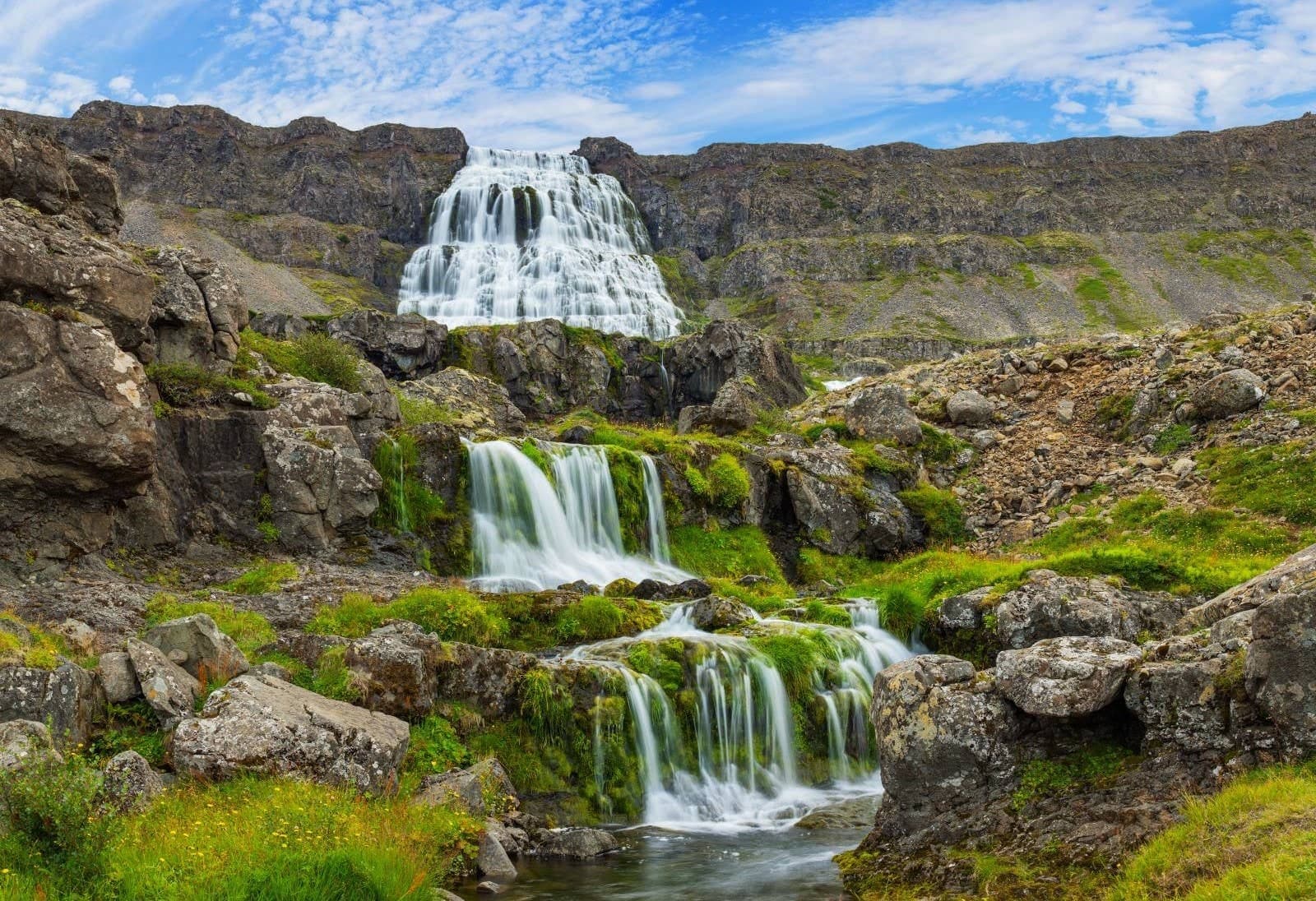
Dynjandi
Dynjandi is the signature Westfjords waterfall, reached by a short uphill walk past smaller cascades to a broad, thunderous main fall.
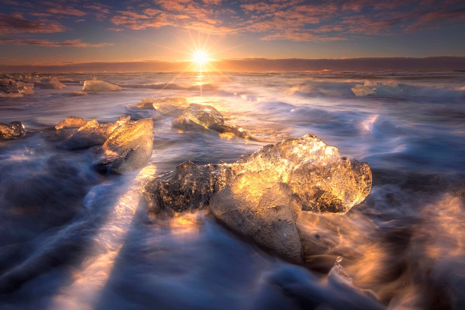
Diamond Beach
Diamond Beach is the black-sand shoreline beside Jökulsárlón where glacier ice can wash ashore, creating one of the South Coast’s most changeable photo stops.

Hallgrímskirkja
Hallgrímskirkja is Reykjavík’s landmark church, with a sculptural exterior, spare interior, large organ, and tower view over the city.

Lóndrangar
Lóndrangar is a pair of basalt sea stacks on the Snæfellsnes coast, best experienced from the marked cliff viewpoints and nearby coastal paths.
All place guides
Find sights worth building into your route.
Search and filter attraction pages and visual collections without mixing in route or region hubs.
What do you want to see?
Where?
Route level
Trip style

Saurbæjarkirkja
Saurbæjarkirkja is a preserved turf church in Eyjafjörður south of Akureyri, best for travelers deciding whether a quiet cultural detour belongs in a North Iceland driving day or should be skipped.
North Iceland · Turf church · Short cultural stop
Hóp Lake
Hóp Lake is a tidal lake and wetland stop in northwestern North Iceland, useful when your day already passes Vatnsdalur, Vatnsnes, or Blönduós and you want a quiet landscape pause.
North Iceland · Tidal lake · Quiet route pause
The Settlement Center
The Settlement Center is a story-led museum in Borgarnes, useful when West Iceland or Snæfellsnes plans need cultural context, an indoor-leaning pause, and enough time to check visitor details before committing.
Museum · Borgarnes · West Iceland
Hítardalur
Hítardalur is a quiet West Iceland valley and old farm estate near Borgarnes, with lava, mountain walls, Hítará river, and saga texture. Visit only if you want a slow rural detour, not a fast headline stop.
West Iceland · Quiet valley · Rural detour
Hrepphólar
Hrepphólar is a small basalt-column and church stop near Flúðir in South Iceland, worth adding only when your Golden Circle day has room for a quiet countryside detour between major sights.
Basalt columns · Golden Circle · South Iceland
Þjórsá
Þjórsá is Iceland's longest river and a South Iceland route corridor, useful when you choose a specific waterfall, valley, or river viewpoint instead of treating it as one simple stop.
South Iceland · River corridor · Self-drive decision
Hvítárvatn
Hvítárvatn is a remote glacial lake beside Langjökull in the Highlands, worth adding when a Road 35 day already has the vehicle, weather, daylight, and route purpose to support it.
Glacial lake · Highlands · Road 35
Eskifjörður
Eskifjörður is a small Eastfjords harbor town below Hólmatindur, useful as a slower Ring Road detour, short fjord stop, or base for nearby walks, maritime history, and coastal viewpoints.
Eastfjords harbor town · Ring Road detour · Hólmatindur views
Bárðarbunga
Bárðarbunga is a powerful subglacial volcano beneath northwestern Vatnajökull, useful for travelers deciding whether its remote Highlands context belongs in a specialist plan or should stay a geology-aware reference point.
Vatnajökull · Subglacial volcano · Highlands
Laugarvatn
Laugarvatn is a small lake village on the Golden Circle, useful when you need a calmer geothermal pause, a lakeside base, or a decision about whether to add time between Þingvellir, Geysir, and Gullfoss.
Golden Circle lake · Geothermal pause · South Iceland
Skriðuklaustur
Skriðuklaustur is a cultural and historic site in Fljótsdalur, East Iceland, where Gunnar Gunnarsson’s turf-roofed house, medieval monastery ruins, and nearby park context make a calm cultural stop worth weighing against drive time.
Fljótsdalur culture stop · Near Egilsstaðir · Gunnarshús and ruins
Nýidalur/Jökuldalur
Nýidalur/Jökuldalur is a remote Central Highlands valley and hut area between major ice caps, useful when you are planning an interior route and need to judge access, time, and conditions before committing.
Central Highlands · F-road stop · Remote valley
Egilsstaðir
Egilsstaðir is East Iceland’s practical inland town beside Lagarfljót, useful as a Ring Road pause, flight gateway, or base for nearby fjords, forests, waterfalls, lake country, and highland-edge drives.
East Iceland base · Ring Road stop · Lagarfljót gateway
Skógar
Skógar is a tiny South Coast village beside Skógafoss, useful when you want to turn a famous waterfall stop into a slower cluster with culture, short walks, and route choices.
Village cluster · South Iceland · South Coast
Þórbergssetur
Þórbergssetur is a culture center and heritage museum at Hali in Suðursveit, useful when a glacier-lagoon driving day needs local history, literary context, and a calmer indoor pause near Jökulsárlón.
Hali museum · Near Jökulsárlón · Indoor Ring Road pause
Þorlákshöfn
Þorlákshöfn is a harbor town on South Iceland's southwest coast, useful when you want a quieter coastal pause, ferry-contingency context, or Lighthouse Trail stop before deciding whether the detour strengthens your day.
Harbor town · South Iceland · Coastal pause
Víti in Krafla
Víti in Krafla is a blue-green maar crater above Lake Mývatn, useful as a short Diamond Circle volcanic stop when road, wind, and rim conditions support more than a quick viewpoint.
North Iceland · Krafla area · Crater lake
Reykir Regional Museum (Hrútafjörður)
Reykir Regional Museum is a small Hrútafjörður cultural stop built around Ófeigur, a shark-fishing boat, farm-life exhibits, and the decision of whether a short museum pause improves a North Iceland drive.
Hrútafjörður · Museum · 30-60 min
Eyjabakkar
Eyjabakkar is a remote East Iceland wetland near Snæfell and Vatnajökull, worth planning only when birdlife, highland scale, flexible access checks, and a slower inland route strengthen your trip.
East Iceland wetland · Highland detour · Birdlife and Snæfell
Grettislaug
Grettislaug is a rustic coastal hot spring at Reykir on Reykjaströnd in Skagafjörður, worth adding when you want a quiet soak, saga context, and enough flexibility to verify visitor details first.
Skagafjörður hot spring · North Iceland detour · saga context · rustic soak
Laufás
Laufás is a preserved turf farm and church site in Eyjafjörður, best added when a North Iceland day needs cultural depth near Akureyri rather than another waterfall or geothermal stop.
Turf farm near Akureyri · 45-90 minutes · North Iceland culture
Kárahnjúkavirkjun
Kárahnjúkavirkjun is Iceland’s largest hydropower complex in the East Iceland highlands, useful for travelers deciding whether the dam, Hálslón reservoir, canyon views, and rougher nearby roads justify an inland detour.
East Iceland · Dam and reservoir · Highland detour
Hólar in Hjaltadalur
Hólar in Hjaltadalur is a historic church, school, and turf-house site in Skagafjörður, best added when a North Iceland route has time for culture, short walks, and a slower detour from Route 1.
Skagafjörður · Historic site · 45-90 min
Virkisjökull Glacier
Virkisjökull is a retreating outlet glacier near Skaftafell in southeast Iceland, worth considering when you want quieter glacier views but only if access, weather, and safety checks fit your South Coast day.
Southeast glacier · Skaftafell area · 30-90 minutes
Vesturdalur Valley
Vesturdalur Valley is a Jökulsárgljúfur walking area in North Iceland, useful when you want basalt formations, river canyon texture, and enough time to choose a marked trail carefully.
Jökulsárgljúfur · Diamond Circle · Marked walks
Vestragil
Vestragil is a small gully and hot-spring area in Skaftafell, best for travelers who already have time in Vatnajökull National Park and need to decide if a quiet side stop is worth adding.
Skaftafell side stop · 30-75 minutes · Access checks matter
Vestari Jökulsá
Vestari Jökulsá is a glacial river canyon in Skagafjörður, best added when you want a guided rafting experience or a river-focused North Iceland detour rather than another roadside viewpoint.
Glacial river canyon · Skagafjörður · Guided rafting fit · North Iceland
Varmahlíð
Varmahlíð is a small Skagafjörður village on the North Iceland route, useful when you need a practical pause, valley view, or base decision rather than a standalone sightseeing detour.
Skagafjörður village · North Iceland route stop · Ring Road pause · Reykjarhóll views
Valshamar
Valshamar is a small basalt climbing crag in Eilífsdalur near Hvalfjörður, useful when you want a specialist outdoor stop and can respect private-land access, weather, and climbing limits.
Kjós · Climbing crag · Specialist stop
Ullarfoss
Ullarfoss is a quiet waterfall on the Svartá side of North Iceland, best considered as an optional add-on near Goðafoss and Aldeyjarfoss when walking effort, weather, and route time all make sense.
North Iceland · Waterfall · Quiet add-on
Úlfarsfell
Úlfarsfell is a low mountain on the edge of Reykjavík and Mosfellsbær, useful when a city day needs a real hike, broad views, and a clear choice between a quick outdoor break and a summit walk.
Reykjavík area · Mountain hike · Short stop
Tindfjallajökull
Tindfjallajökull is a remote glacier-capped volcano above South Iceland’s highland edge, worth considering when you want wild mountain views but need to decide whether a distant view is enough.
South Iceland · Glacier volcano · Highland access
Þríhnúkagígur
Þríhnúkagígur is a dormant volcano near Reykjavík where guided visitors descend into an empty magma chamber, worth choosing when a booked half-day adventure fits your weather, budget, and energy.
Volcano · Near Reykjavík · Guided descent · Half-day experience
Þórisjökull
Þórisjökull is a small glacier-capped volcano near Kaldidalur in the western Highlands, worth adding only when the rough approach, weather, vehicle rules, and route purpose all support the detour.
Glacier-volcano · Highlands · Kaldidalur
Þjórsárdalur
Þjórsárdalur is a South Iceland valley east of the classic Golden Circle, best for travelers choosing between a compact scenic add-on and a slower day around waterfalls, Gjáin, and historic Stöng.
South Iceland · Golden Circle extension · Valley cluster
Þjófatindar
Þjófatindar is a mountain-peaks stop above the Ísafjörður area, best for travelers deciding whether a flexible Westfjords day can include a weather-dependent valley-to-valley walk with real scenic payoff.
Mountain walk · Westfjords · Near Ísafjörður
Þjóðveldisbærinn at Stöng
Þjóðveldisbærinn at Stöng is a reconstructed medieval turf farm in Þjórsárdalur, best for travelers deciding whether South Iceland history deserves space beside waterfalls and Golden Circle detours nearby.
South Iceland · Historic site · Golden Circle extension
Þingvallavatn
Þingvallavatn is the broad lake beside Þingvellir on the Golden Circle, useful when you want landscape scale, rift-water context, or a quieter pause beyond the main park paths.
Golden Circle · Lake and rift landscape · Þingvellir context
Syðridalur
Syðridalur is a quiet Westfjords valley above Bolungarvík, useful for travelers deciding whether a short scenic detour, old mine walk, and northern fjord context deserve time in a slower Westfjords day.
Quiet Westfjords valley · Near Bolungarvík · Short scenic detour · Westfjords Way
Svartsengi Power Station
Svartsengi Power Station is a working geothermal plant beside the Blue Lagoon on the Reykjanes Peninsula, useful as a quick context stop only when the wider volcanic and spa landscape already fits your day.
Reykjanes Peninsula · Geothermal power · Quick context stop
Stykkishólmur
Stykkishólmur is a compact harbor town on north Snæfellsnes, useful for travelers deciding whether to make a quick scenic stop, slow down overnight, or use the ferry link toward Breiðafjörður and the Westfjords.
Harbor town · North Snæfellsnes base · Breiðafjörður views · Ferry gateway
Strýtur
Strýtur is a protected underwater geothermal chimney field in Eyjafjörður, North Iceland, worth planning only for qualified divers or geology-focused travelers who can build the visit around operator, weather, road, and sea-condition checks.
North Iceland · Underwater geothermal site · Specialist access
Strútslaug
Strútslaug is a remote natural hot spring in Iceland's South Highlands, worth planning only when highland roads, weather, hiking effort, group confidence, and route timing make the journey realistic.
Remote hot spring · South Highlands · Hike and soak
Strokkur
Strokkur is the active geyser most travelers wait for in the Geysir geothermal area, a quick Golden Circle stop where timing, crowds, wind, and safe marked paths decide the visit.
Golden Circle · Geothermal area · Short stop · First-time favorite
Stóri-Bolli
Stóri-Bolli is a rugged volcanic crater in the Bláfjöll area near Reykjavík, worth adding only when rough walking, mountain weather, and road conditions fit your southwest Iceland plan.
Near Reykjavík · Volcanic crater · Weather-dependent
Stakkholtsgjá
Stakkholtsgjá is a narrow canyon near Þórsmörk in South Iceland, reached by high-friction F-road access and river crossings; visit for the stream-bed walk and waterfall chamber only when conditions and access checks support the detour.
Canyon walk · South Iceland · Þórsmörk side
Sólheimasandur
Sólheimasandur is an exposed black-sand outwash plain on Iceland's South Coast, known for the DC-3 plane wreck; visit only if the long walk, weather, and daylight strengthen rather than crowd your route.
South Coast black sand · DC-3 wreck walk · Weather-sensitive stop · Near Skógar and Vík
Sólheimajökull Glacier
Sólheimajökull is an accessible South Coast glacier tongue where travelers can view Mýrdalsjökull ice up close, then decide whether a guided glacier walk is worth the time, cost, and safety checks.
South Coast glacier · Viewpoint or guided hike · Near Skógar and Vík · Road 221 access check
Snorrastofa
Snorrastofa is a medieval cultural and research centre in Reykholt, best added when West Iceland needs saga history, a short indoor pause, and nearby waterfall or geothermal pairings.
Cultural site · West Iceland · Silver Circle
Skútustaðagígar
Skútustaðagígar is a protected group of grassy pseudocraters on the south side of Lake Mývatn, worth adding when you want an easy volcanic walk, birdlife, and a calmer North Iceland stop.
North Iceland · Lake Mývatn · Pseudocraters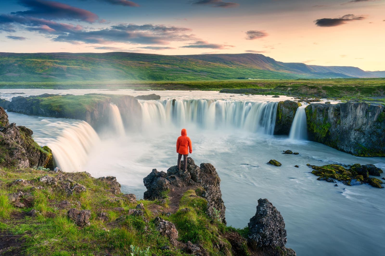
Skjálfandafljót
Skjálfandafljót is the North Iceland river behind Goðafoss, Aldeyjarfoss, and upper highland-edge waterfalls, worth planning around when you want to choose the right river stop instead of chasing every cascade.
North Iceland · River waterfalls · Goðafoss and Aldeyjarfoss
Skjaldbreiður
Skjaldbreiður is a broad shield volcano north of Þingvellir, best for prepared self-drive travelers deciding whether highland-edge scenery and geology justify extra time beyond the classic Golden Circle stops.
Shield volcano · Near Þingvellir · Golden Circle extension · Road-sensitive detour
Skeiðarársandur
Skeiðarársandur is the vast black-sand outwash plain between Vatnajökull and the Atlantic, best judged as a scenic Route 1 context stop rather than a destination that replaces Skaftafell or Jökulsárlón.
South Coast · Route 1 · Black-sand plain
Skálholt
Skálholt is a historic cathedral site in South Iceland, useful when a Golden Circle day needs culture, quiet walking, and context between the bigger natural landmarks without adding another scenic viewpoint.
Historic cathedral · Golden Circle · South Iceland · Culture stop
Skagafjörður
Skagafjörður is a broad fjord and horse-country destination in North Iceland, useful when you want a slower Ring Road segment with turf history, coastal villages, birdlife, and room for weather-aware detours.
North Iceland · Fjord and horse country · Ring Road segment
Silfra
Silfra is the clear-water fissure inside Þingvellir National Park, best for travelers who want a guided cold-water snorkel or dive and can let that activity shape a Golden Circle day.
South Iceland · Golden Circle · Guided cold-water activity
Seyðisfjörður
Seyðisfjörður is a colorful harbor town at the end of an Eastfjords road, worth the Route 93 detour when you have time for mountain views, Rainbow Street, and a slower fjord stop.
Eastfjords town detour · Route 93 harbor stop · Rainbow Street and fjord views
Seljalandsdalur
Seljalandsdalur is a mountain valley above Ísafjörður in the Westfjords, useful for cross-country skiing, short scenic walks, and valley-to-valley hikes when weather, snow, and trail conditions make a quiet outdoor stop worthwhile.
Ísafjörður add-on · Westfjords valley · Ski and walking
Selfoss Waterfall
Selfoss Waterfall is the broad, lower waterfall upstream from Dettifoss in North Iceland, worth adding when the canyon walk, road conditions, and your Diamond Circle timing leave enough margin.
North Iceland · Diamond Circle · Waterfall add-on
Sandvík
Sandvík is a small Reykjanes cove with black sand, grassy dunes, a brackish pond, and nearby Bridge Between Continents, worth adding when your peninsula drive has room for a slow coastal-geology stop.
Reykjanes Peninsula · Black-sand cove · 20-45 minutes
Reykjadalur
Reykjadalur is a geothermal valley and warm-river hike above Hveragerði, worth adding when you want an active half-day stop and are ready to check weather, trail, and bathing conditions before committing.
Hot river hike · Near Hveragerði · Half-day stop
Öxarfjörður
Öxarfjörður is a wide North Iceland fjord between Tjörnes and Melrakkaslétta, best for travelers deciding whether the quiet coast deserves time between Húsavík, Ásbyrgi, Dettifoss, and the Arctic Coast Way.
North Iceland fjord area · Kópasker and Hringsbjarg views · Near Ásbyrgi and Dettifoss · Best for slower self-drive days
Öskjuvatn
Öskjuvatn is the deep caldera lake inside Askja in North Iceland’s Highlands, worth slowing down for only when the full Askja access, weather, vehicle, and safety picture makes sense.
North Iceland · Askja · Highland lake
Öræfajökull Glacier
Öræfajökull is the glacier-covered volcano above Skaftafell in southeast Iceland, where travelers need to choose between scenic views, nearby outlet-glacier stops, or a serious guided mountain objective with official checks.
South Iceland · Glacier volcano · Skaftafell area
Ölkelda Mineral Spring
Ölkelda is a small naturally carbonated mineral spring on south Snæfellsnes, worth a short stop when its iron-red water and farm setting fit your route without crowding better nearby sights.
Mineral spring · Snæfellsnes · Quick stop
Ódáðahraun
Ódáðahraun is a vast lava desert north of Vatnajökull, useful for travelers deciding whether a Highlands route should focus on Askja, Holuhraun, rough roads, or easier alternatives nearby.
Lava desert · Highlands · Askja context
Nesjavellir
Nesjavellir is a geothermal power-station landscape north of Hengill, useful for self-drivers who want Road 435 views, steam, mountain scale, and a quieter Golden Circle detour with condition checks.
Geothermal area · Near Hengill · Road 435 detour
Mýrdalsjökull Glacier
Mýrdalsjökull is a large South Coast glacier above Katla, best planned as a route-defining landscape where travelers must choose between distant views, guided glacier access, or a simpler nearby stop.
South Iceland · Glacier and Katla · Guided access checks
Möðrudalur
Möðrudalur is a highland-edge farm settlement on Road 901 in Northeast Iceland, worth a stop when you want cultural texture, Herðubreið views, and a slower pause between Mývatn, Dettifoss, Askja access, and East Iceland.
Northeast Iceland · Farm settlement · Road 901
Magni
Magni is a young volcanic cone on Fimmvörðuháls in South Iceland, worth considering only when you are already planning the mountain route and can handle the access, weather, time, and safety checks.
Volcanic crater · Fimmvörðuháls · South Coast
Lúdentarborgir
Lúdentarborgir is a quiet crater row southeast of Lake Mývatn, useful for geology-minded self-drivers deciding whether a rougher volcanic side stop adds enough context beside easier Mývatn sights.
North Iceland · Crater row · Mývatn side stop
Lofthellir
Lofthellir is a guided lava-tube ice cave near Lake Mývatn, worth considering when you want a demanding North Iceland cave experience and can handle crawling, darkness, uneven ice, and operator-led access.
North Iceland · Lake Mývatn · Guided ice cave
Ljótipollur
Ljótipollur is a red-walled crater lake near Landmannalaugar in the South Highlands, best for travelers deciding whether a short crater-rim detour is worth the F-road access, walking, weather, and route time.
Crater lake · South Highlands · F-road access
Leirhnjúkur
Leirhnjúkur is a steaming volcanic crater and lava-field walk in the Krafla area near Lake Mývatn, worth adding when you have time for uneven geothermal ground beyond the easier roadside stops.
North Iceland · Krafla lava field · 45-90 minutes
Leifsbúð
Leifsbúð is a small Vínland and Leifur Eiríksson exhibition in Búðardalur, best used when a Westfjords Way or Dalir driving day needs a short cultural pause rather than another landscape stop.
Cultural site · Búðardalur · Westfjords Way
Leiðarendi Cave
Leiðarendi Cave is an undeveloped lava tube near Bláfjöll and Hafnarfjörður, worth adding only if a guided, physical underground stop fits your Reykjavík or southwest Iceland day.
Near Reykjavík · Lava cave · Guided safety check
Langjökull
Langjökull is Iceland's second-largest glacier, a west-highland ice cap where the main decision is whether guided access, road conditions, weather, and route timing make the visit worth the effort.
Glacier · Highlands · Húsafell access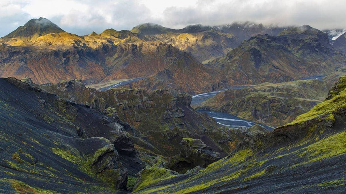
Kristnitökuhraun Lava Field
Kristnitökuhraun is a young lava field on the Hellisheiði corridor near Reykjavík, useful as a short geology-and-history pause when your drive already crosses this exposed part of southwest Iceland.
Southwest Iceland · Lava field · Short stop
Krakatindur
Krakatindur is a jagged volcanic mountain near Hekla in South Iceland's Highlands, best for prepared summer drivers deciding whether a rough-track detour is worth the access, weather, and vehicle commitment.
Hekla-area mountain · Highland track · Remote 4x4 detour
Krafla
Krafla is a volcanic area north of Lake Mývatn, where Víti crater, Leirhnjúkur lava fields, steam, and a geothermal power station make a strong but condition-sensitive North Iceland stop.
North Iceland · Mývatn area · Volcanic landscape
Klettshellir
Klettshellir is a large sea cave beneath Ystiklettur in the Westman Islands, worth planning only when a boat trip, sea conditions, ferry timing, and island-day priorities all make sense.
Westman Islands · Sea cave · Boat access
Kleifarvatn
Kleifarvatn is a deep volcanic lake on the Reykjanes Peninsula, worth adding when you have a self-drive loop, clear visibility, and enough time to pair it with nearby geothermal stops.
Reykjanes Peninsula · Lake and volcanic shoreline · 20-60 minutes
Kirkjubólsdalur
Kirkjubólsdalur is a quiet Westfjords valley near the mountain country around Dynjandi and Arnarfjörður. Add it when you want a slower scenic detour, not a fast checklist attraction.
Westfjords valley · Quiet scenic detour · Dynjandi / Arnarfjörður · Westfjords Way
Katla
Katla is an active volcano beneath Mýrdalsjökull on Iceland’s South Coast, best planned as a safety-sensitive landscape stop where the main decision is whether to view it, book guided access, or skip close plans.
South Iceland · Volcano under glacier · Safety checks
Kaldidalur
Kaldidalur is a stark highland valley on Road 550 between the Þingvellir side and Húsafell, worth adding only when road, weather, vehicle, and route time all support the drive.
Highlands · Road 550 · Gravel access
Kaldbakur
Kaldbakur is the highest mountain in the Westfjords, rising between Dýrafjörður and Arnarfjörður. Add it there when you want a real mountain objective, not just another scenic stop.
Westfjords mountain · Half-day hiking objective · Dýrafjörður / Arnarfjörður · Westfjords Way
Jökulsárgljúfur
Jökulsárgljúfur is a protected canyon corridor in North Iceland between Dettifoss and Ásbyrgi, worth planning as a Diamond Circle landscape area when you have time for viewpoints, marked walks, and road-condition checks.
North Iceland · Diamond Circle · Canyon corridor
Jökulsá á Fjöllum
Jökulsá á Fjöllum is the glacial river behind Dettifoss and Jökulsárgljúfur in North Iceland, worth planning around when you want waterfall power, canyon scale, and a realistic Diamond Circle day.
North Iceland · Diamond Circle · Glacial river
Hverfell
Hverfell is a dark volcanic crater beside Lake Mývatn, best for travelers who want a short climb, wide crater-rim views, and enough flexibility to skip it when wind, ice, or tight timing weakens the stop.
North Iceland · Volcanic crater · Diamond Circle · 45-90 minutes
Hveravellir
Hveravellir is a remote geothermal area and hot-pool stop on Road 35 in the Highlands, worth adding only when road, weather, vehicle, and time checks support the detour.
Geothermal area · Highlands · Road 35
Hveragerði
Hveragerði is a geothermal town east of Reykjavík, useful as a quick stop, soft overnight base, or Reykjadalur gateway when you decide how much time to give the steam, walks, and nearby routes.
Geothermal town · South Iceland · Golden Circle edge
Hvannadalshnúkur
Hvannadalshnúkur is Iceland's highest peak, rising from Öræfajökull above Skaftafell, where travelers must choose between admiring the mountain from the South Coast or committing to a demanding guided glacier summit.
South Iceland · Highest peak · Guided glacier summit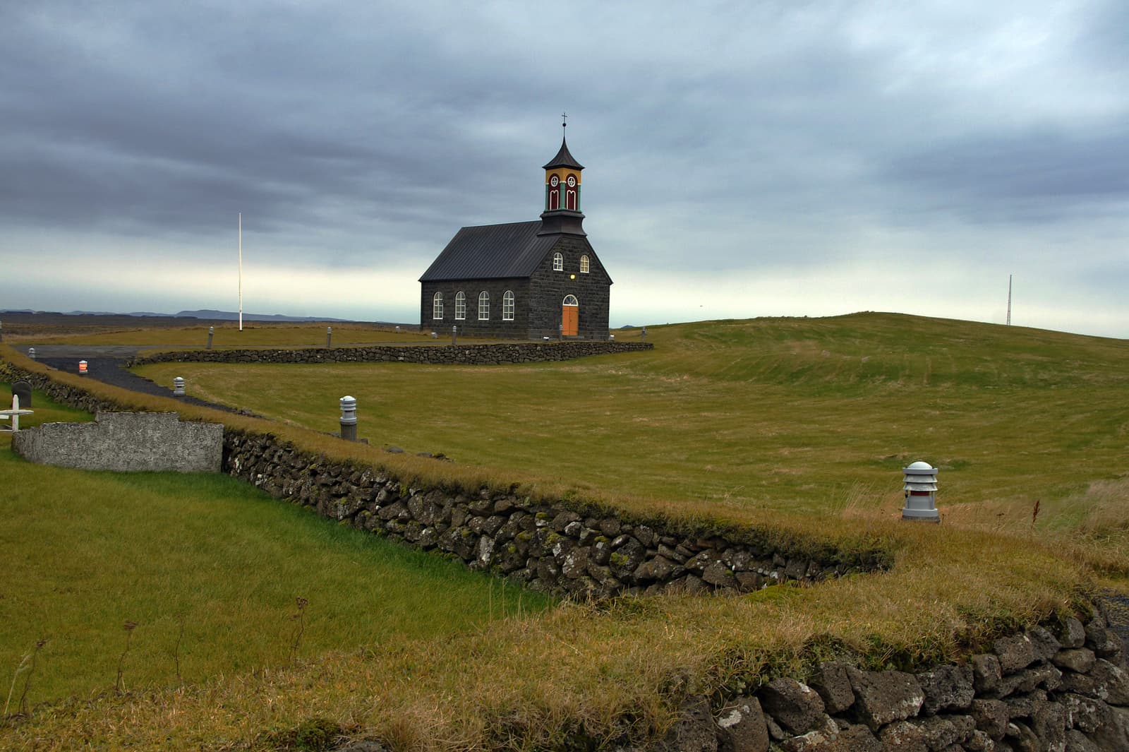
Hvalsneskirkja
Hvalsneskirkja is a historic stone church in Hvalsnes on the Reykjanes Peninsula, best added when you want a quiet cultural pause near Keflavík or Sandgerði rather than another major scenery stop.
Historic church · Reykjanes · Short stop
Hvalfjörður
Hvalfjörður is a broad fjord north of Reykjavík where Route 47 gives self-drive travelers a slower scenic alternative to the tunnel, worth adding when you want quiet viewpoints, Glymur access, and West Iceland context.
West Iceland · Route 47 · Fjord drive
Húsafell
Húsafell is a wooded West Iceland destination area in Borgarfjörður, best used when you need a quiet Silver Circle base, a scenic break, or time for nearby baths, caves, glaciers, and waterfalls.
West Iceland · Silver Circle · Base and trails
Hrafnabjargafoss
Hrafnabjargafoss is a remote Skjálfandafljót waterfall above Aldeyjarfoss in North Iceland, worth adding only when road conditions, vehicle choice, daylight, and walking time support a rougher valley detour.
North Iceland · Remote waterfall · Aldeyjarfoss area
Build a trip around the places you want to see.
Once the sights are clear, use planning pages to turn them into a route with realistic timing.