Reynisfjara is a dramatic South Coast black sand beach near Vík, best treated as a viewpoint-first stop where surf, erosion, warning lights, and local instructions control the visit.
Quick guide
Type
Black sand beach with basalt columns and sea stacks
Region
South Iceland, near Vík
Route context
Classic South Coast and Ring Road stop
Time to allow
Usually 30 to 60 minutes, longer if paired with Dyrhólaey
Best experience
View the surf, basalt, and Reynisdrangar from a safe distance
Access reality
SafeTravel describes access as viewpoint-only; lower-beach access can change
Safety note
Stay well back from the water and never turn your back on the sea
Pairings
Dyrhólaey, Vík, Skógafoss, and Sólheimajökull Glacier
Is Reynisfjara worth visiting?
Yes, Reynisfjara is worth visiting for most South Coast travelers, but only if you treat it as a powerful viewpoint rather than a normal beach.
The beach has a rare combination in one compact stop: black volcanic sand, hexagonal basalt columns, Reynisdrangar sea stacks, cliffs, wind, and the Atlantic moving with real force. That is why it remains one of the most memorable places near Vík and a natural part of many South Coast road trips.
The catch is that the ocean is not background scenery here. Sneaker waves, strong currents, rockfall risk, shoreline change, and temporary restrictions can alter what is safe on the day you arrive. If your group can respect that, Reynisfjara earns its place. If anyone wants to stand close to the water, climb for photos, or treat warning lights as suggestions, choose an easier stop instead.
Photo guide
Reynisfjara in photos
At Reynisfjara, the safe viewing distance matters more than the photo angle.
Worth the stop?
When this stop makes sense
Good match for
first-time South Coast travelers who want a powerful coastal stop
photographers who can keep a safe distance from the surf
self-drive visitors staying in or passing through Vík
travelers pairing beach scenery with Dyrhólaey and nearby waterfalls
Think twice if
anyone hoping to swim, paddle, or play near the waterline
families who cannot keep children close on an exposed beach
Reynisfjara feels less like a beach day and more like standing at the edge of a live volcanic coastline.
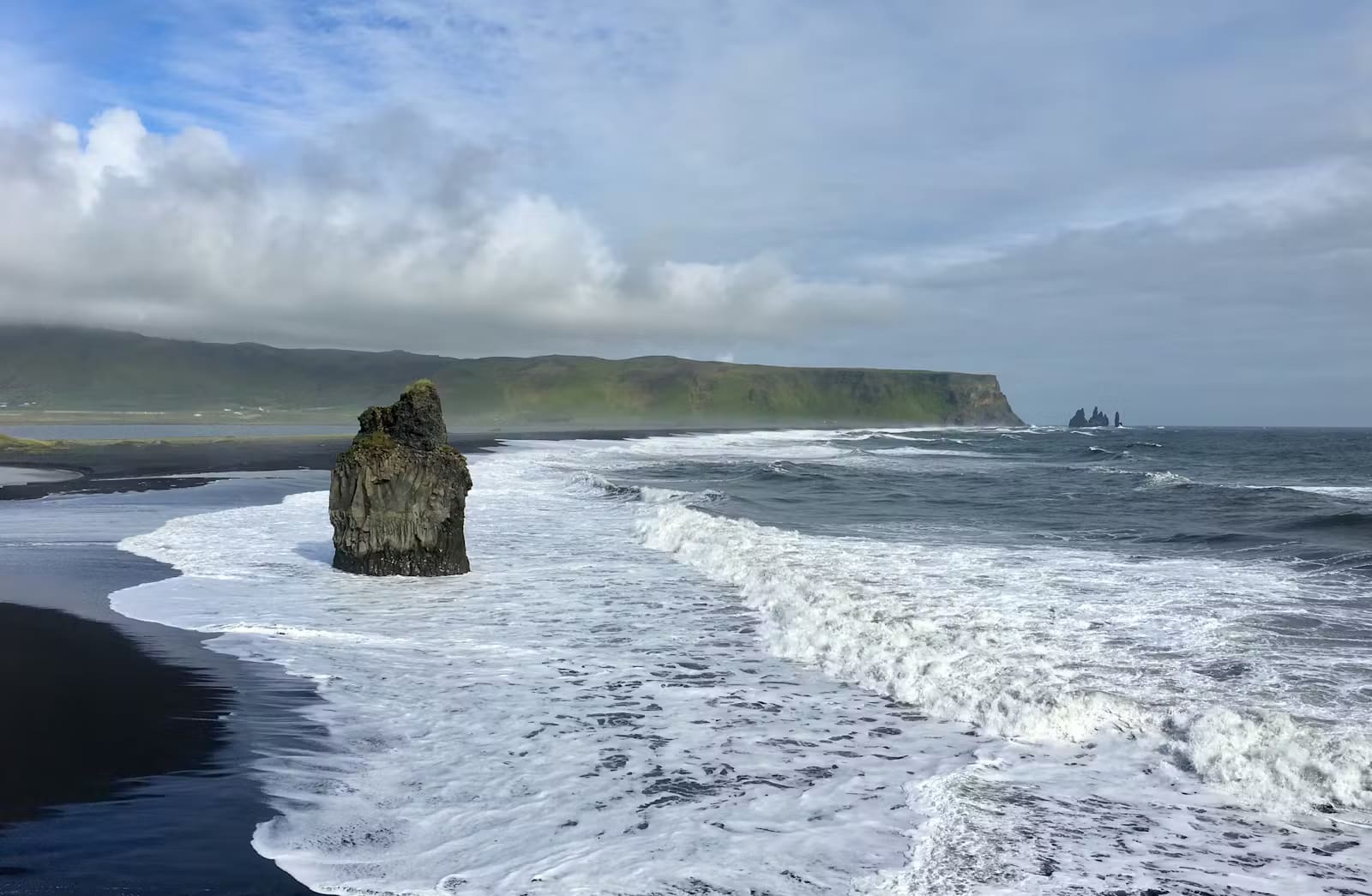
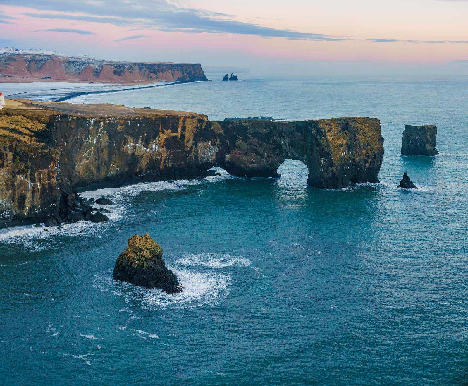
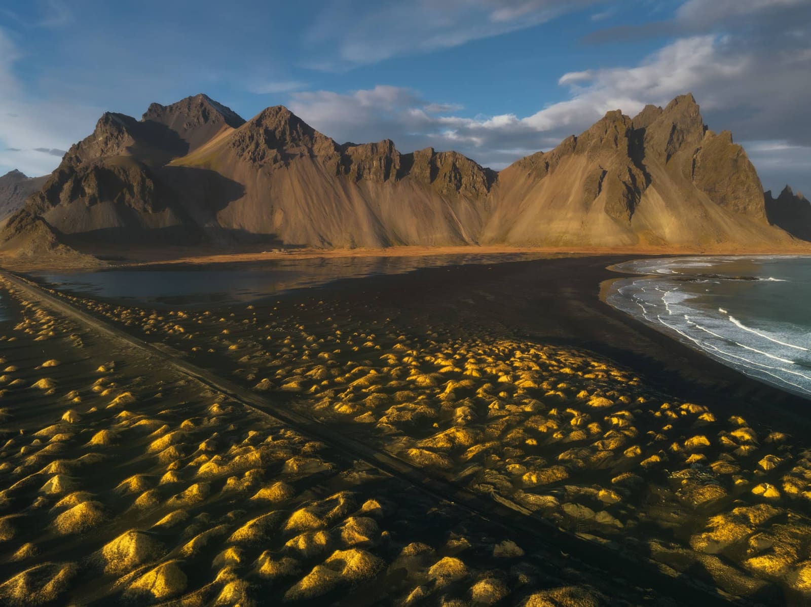
The first impression is usually the contrast: dark sand underfoot, white surf rolling in, and the sharp shapes of Reynisdrangar offshore. At one end of the beach, basalt columns rise in geometric stacks below Reynisfjall. On clear days, the view west toward Dyrhólaey gives the whole coastline more shape.
Black sand and pebbles formed from volcanic material.
Reynisdrangar sea stacks standing offshore from the beach.
Basalt columns and cliff textures near the eastern end of the beach.
Powerful surf that can look beautiful and dangerous at the same time.
Views toward Dyrhólaey and the wider Vík-area coastline when visibility is good.
The best photos usually do not require getting close to the sea. Wide views that include the surf line, sea stacks, and basalt give a stronger sense of place than risky waterline shots.
Access, warning lights, and danger zones
SafeTravel and on-site instructions should decide how close you go; when restrictions apply, treat the designated viewpoint as the visit.
Official access guidance matters more than old photos or older itineraries. February 2026 erosion undermined the viewing platform and two safety signs; one zoning-map sign collapsed, and the illuminated warning sign was removed because its foundations had become unsafe. When guidance limits visitors to upper viewpoints, use those views toward the basalt columns and surf rather than trying to walk down to the columns.
Reynisfjara's warning signs are part of the visit. Safety infrastructure and shoreline conditions can change, so lights, barriers, and local instructions always override older photos.
On-site signs, warning lights, ropes, barriers, and staff instructions are the rule on the day you arrive. Do not assume access is safe because other visitors walk down, because the beach looked open in a recent video, or because a map app still shows a path to the basalt columns.
The surf at Reynisfjara can reach the basalt cliffs and change the safe visit area quickly.
Read current SafeTravel Black Beach guidance before you go.
Obey on-site lights, barriers, signs, and staff instructions even when other visitors ignore them.
Do not swim, paddle, step into the foam, or walk onto wet sand for a photo.
Stay away from cliff bases, cave mouths, and rockfall-prone areas unless current signs clearly allow access.
In orange conditions, keep at least 25 m from the sea; in red conditions, stay off the beach and use the viewpoint.
Keep children within arm's reach in exposed areas.
Leave immediately if wind, waves, visibility, or crowd behavior makes the stop feel unsafe.
How long Reynisfjara needs near Vík
Most travelers need enough time to look, photograph, adjust to the safety zones, and move on without rushing toward the surf.
A practical stop is often 30 to 60 minutes. The short end works if you simply want the main view and conditions are straightforward. Allow more time if you are pairing Reynisfjara with Dyrhólaey, waiting for better light, traveling with a family, or moving more slowly because wind and surf make the site feel exposed.
How to budget Reynisfjara time
Visit style
Time to allow
Best use
Quick viewpoint stop
30 minutes
See the beach, sea stacks, and surf from safe areas.
Take photos, read conditions, and avoid rushing the group.
Vík-area coastal pairing
1.5 to 2.5 hours with Dyrhólaey
Compare ground-level beach drama with the elevated cliff view.
Do not plan the visit by parking-lot distance alone. The beach is physically easy to reach, but the decision-making takes attention.
Dyrhólaey, Skógafoss, and the South Coast stops that pair naturally
Reynisfjara works best inside the Vík-area cluster rather than as an isolated detour.
The strongest nearby pairing is Dyrhólaey. Reynisfjara gives you the ground-level black-sand coast, while Dyrhólaey gives you height, cliffs, and a broader view over the same coastline. If conditions make Reynisfjara less accessible, Dyrhólaey can still give a powerful coastal perspective when its own access is suitable.
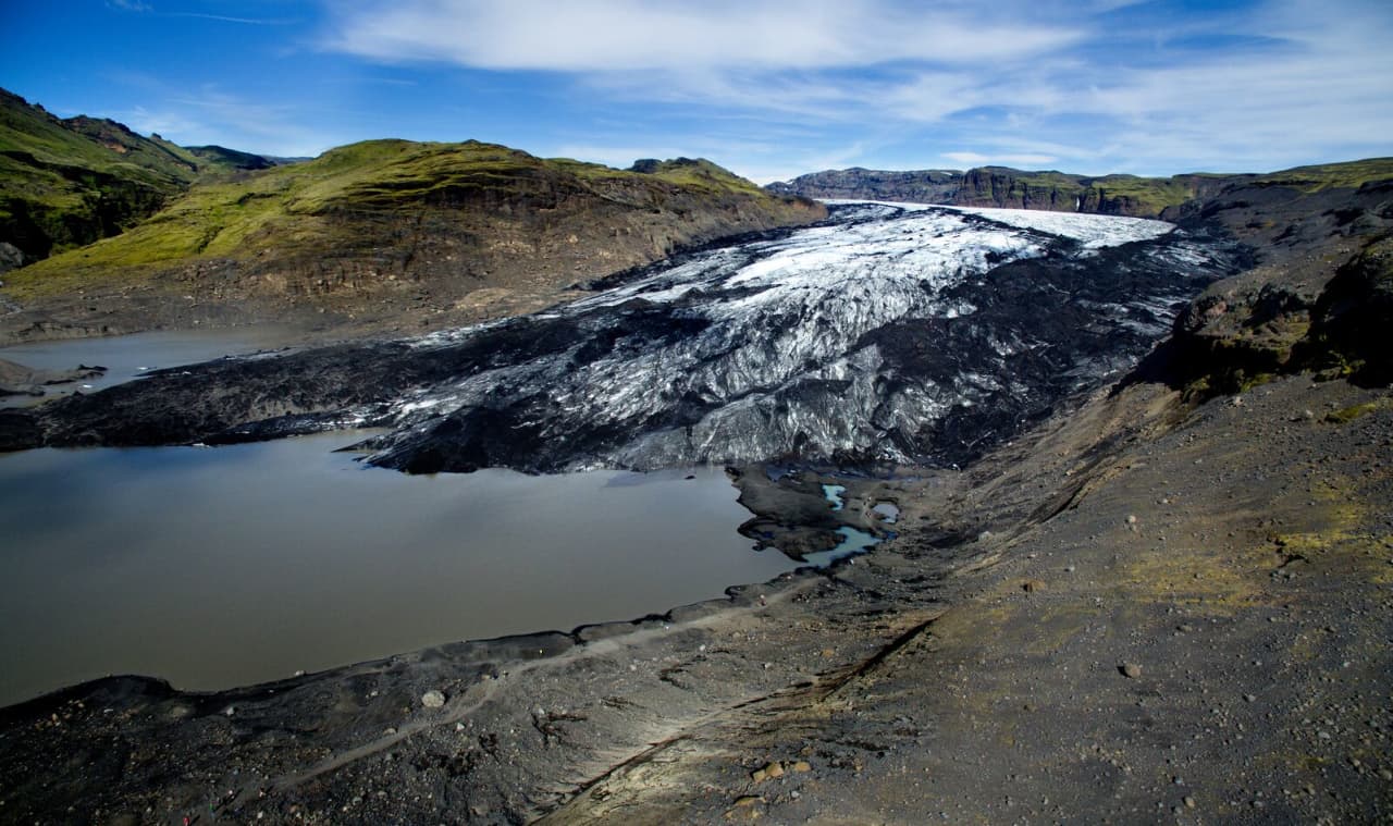
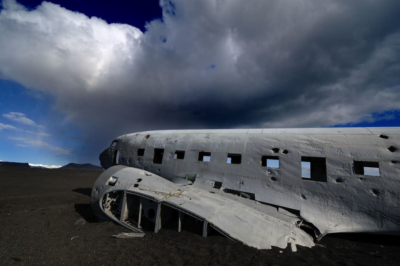
West of the Vík area, Skógafoss and Sólheimajökull Glacier often shape the same driving day. That creates a good contrast: waterfall scale, glacier edge, and black-sand coast. Sólheimasandur is nearby too, but it takes more walking time and should compete for space rather than being added automatically.
Pair with Dyrhólaey when coastal views are a priority.
Pair with Skógafoss when building a classic west-to-east South Coast day.
Pair with Sólheimajökull Glacier if you want ice and black sand in the same route segment.
Treat Sólheimasandur as a separate time tradeoff, not a quick beach add-on.
What erosion, weather, and season can change
Reynisfjara is open-air, exposed, and actively shaped by the sea, so the safe visit area can change from one day to the next.
The 2026 erosion is the clearest recent example. Regional and government tourism sources describe Reynisfjara as open, but also changed: storms, high sea levels, persistent swell, and wind direction shifted large volumes of black sand, damaged safety infrastructure, and changed what visitors could safely reach.
Recent-condition photos are useful for scale, but Reynisfjara changes quickly; current SafeTravel and on-site restrictions decide where visitors may stand.
Summer gives longer daylight, easier route timing, and a better chance of adding nearby birdwatching around the Vík and Dyrhólaey area. It can also bring heavier crowds and more people making poor decisions near the surf, so do not let other visitors set your safety standard.
Winter can make the beach feel darker, wilder, and more dramatic, but daylight, wind, road conditions, and wave behavior become bigger constraints. Storms and coastal erosion can also change which signs, viewing platforms, paths, or lower-beach areas are usable. Treat the basalt columns, cave area, and waterline as conditional access, not guaranteed stops.
The practical planning lesson is simple: Reynisfjara is not a fixed access promise. Check same-day SafeTravel, weather, road, and local updates before relying on a specific photo spot, and be ready for a viewpoint-only visit.
When Reynisfjara is the wrong stop for the day
The right answer is sometimes to shorten the visit, stay at the viewpoint, or skip it completely.
Skip or shorten Reynisfjara if warning lights, closures, wind, visibility, surf, or group behavior make the stop hard to control. This is especially true with children, distracted photographers, or anyone who wants to test how close they can stand to the water.
It is also reasonable to skip the beach if your South Coast day is overloaded. A route with Seljalandsfoss, Skógafoss, Sólheimajökull, Dyrhólaey, Reynisfjara, meals, and a long return drive can look efficient on a map and feel rushed on the ground. In that case, choose the stops with the best conditions and strongest personal appeal.
Choose Dyrhólaey if you want a safer elevated view over the same coastline and access is suitable.
Choose Skógafoss if the group needs a simpler high-impact stop.
Choose Sólheimajökull if glacier scenery matters more than beach drama.
Keep Reynisfjara optional when weather and surf are unsettled.
Reynisfjara questions travelers should answer before going
These are the practical questions that usually decide whether the stop belongs in the day.
How long should I spend at Reynisfjara?
Most travelers should allow 30 to 60 minutes at Reynisfjara. Add more time if you are pairing it with Dyrhólaey, waiting for safe photo conditions, or traveling with a group that needs slower supervision.
Is Reynisfjara safe to visit?
Reynisfjara can be visited safely only when you stay well back from the sea and follow current warnings, barriers, and signs. The danger comes from unpredictable sneaker waves, strong currents, rockfall areas, and changing shoreline conditions.
Can you swim at Reynisfjara?
No, you should not swim, paddle, or dip your feet at Reynisfjara. The surf and currents are dangerous even when the ocean looks calm.
Can I walk to the basalt columns now?
Do not rely on being able to walk down to the basalt columns. SafeTravel describes Reynisfjara as viewpoint-only, and 2026 official notices described periods when visitors could only view the columns from the upper beach ridge.
What do the Reynisfjara warning lights mean?
Yellow means moderate hazard, orange means considerable hazard and a need to stay well away from the water, and red means severe hazard with the beach closed. In red conditions, use the designated viewing area instead of entering the beach.
Is Reynisfjara good for families?
Reynisfjara can work for families only if children stay close and adults treat the beach as a supervised viewpoint. If your group wants free beach play, choose another stop.
Should I visit Reynisfjara or Dyrhólaey?
Visit both if time, weather, and access allow because they show the same coast from different perspectives. Choose Dyrhólaey first if you want an elevated view or if Reynisfjara's beach access feels too restricted on the day.
Can Reynisfjara fit into a day trip from Reykjavík?
Yes, Reynisfjara can fit a long South Coast day from Reykjavík, but the plan gets weaker if you add too many other stops. In winter, shorter daylight makes a Vík-area overnight or a tighter stop list more realistic.
Official sources to check before visiting Reynisfjara
Because Reynisfjara changes with surf, weather, erosion, and safety management, current sources matter more here than at a simple roadside viewpoint.