
Places to see
Iceland Attractions
Use this page to find the landmarks, landscapes, and scenic areas worth building your route around.
Useful for
Where to start
Start with a few route-shaping sights.
Use these as quick entry points. The full attraction list is in the searchable results below.

Gullfoss Waterfall
Gullfoss is the Golden Circle waterfall that feels powerful even on a short stop, but it is best planned with viewpoint time, weather, and nearby stops in mind.

Reynisfjara
Reynisfjara is a dramatic South Coast black sand beach near Vík, currently best treated as a viewpoint-first stop because surf, erosion, and warning lights control access.
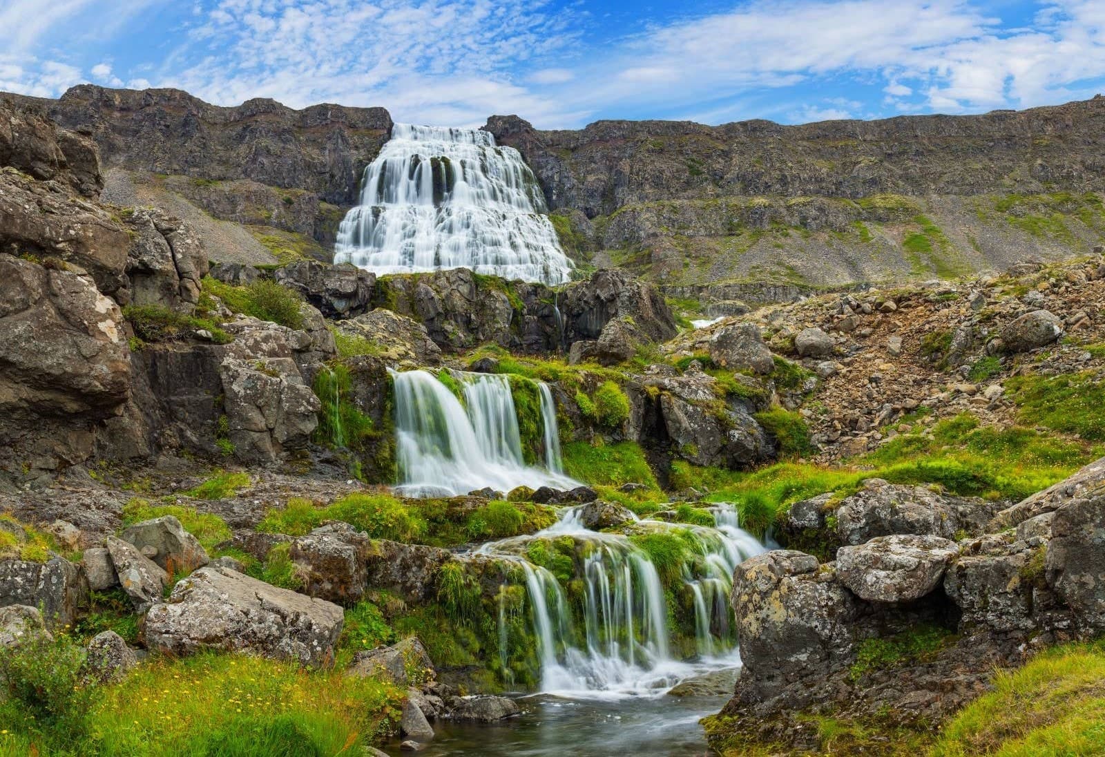
Dynjandi
Dynjandi is the signature Westfjords waterfall, reached by a short uphill walk past smaller cascades to a broad, thunderous main fall.
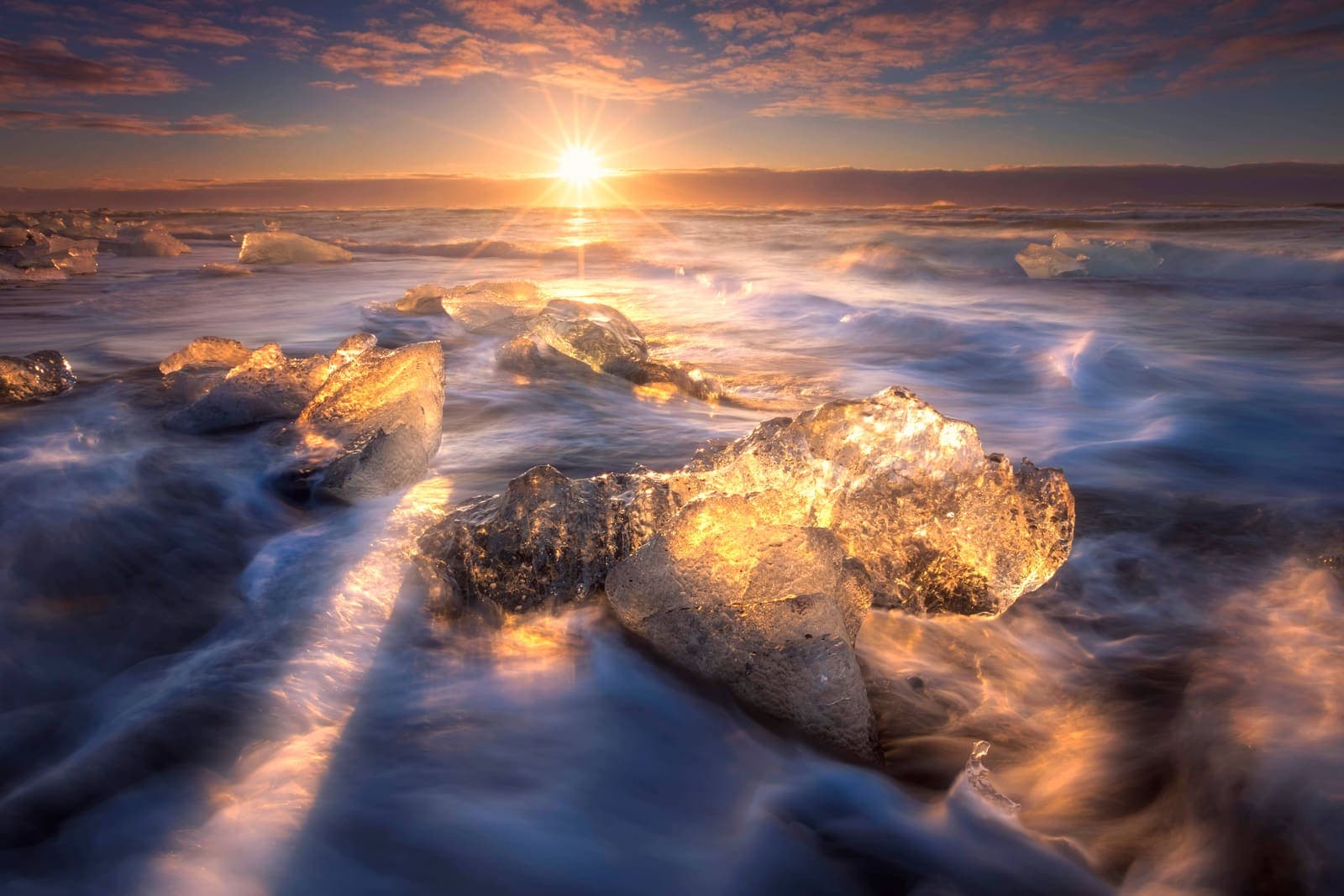
Diamond Beach
Diamond Beach is the black-sand shoreline beside Jökulsárlón where glacier ice can wash ashore, creating one of the South Coast’s most changeable photo stops.

Hallgrímskirkja
Hallgrímskirkja is Reykjavík’s landmark church, with a sculptural exterior, spare interior, large organ, and tower view over the city.

Lóndrangar
Lóndrangar is a pair of basalt sea stacks on the Snæfellsnes coast, best experienced from the marked cliff viewpoints and nearby coastal paths.
All place guides
Find sights worth building into your route.
Search and filter attraction pages and visual collections without mixing in route or region hubs.
What do you want to see?
Where?
Route level
Trip style

Saurbæjarkirkja
Saurbæjarkirkja is a preserved turf church in Eyjafjörður south of Akureyri, best for travelers deciding whether a quiet cultural detour belongs in a North Iceland driving day or should be skipped.
North Iceland · Turf church · Short cultural stop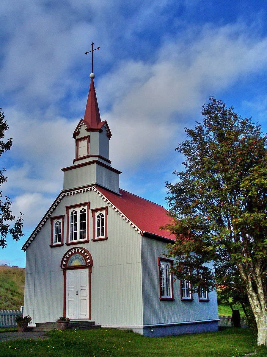
Hrepphólar
Hrepphólar is a small basalt-column and church stop near Flúðir in South Iceland, worth adding only when your Golden Circle day has room for a quiet countryside detour between major sights.
Basalt columns · Golden Circle · South Iceland
Þjórsá
Þjórsá is Iceland's longest river and a South Iceland route corridor, useful when you choose a specific waterfall, valley, or river viewpoint instead of treating it as one simple stop.
South Iceland · River corridor · Self-drive decision
Hvítárvatn
Hvítárvatn is a remote glacial lake beside Langjökull in the Highlands, worth adding when a Road 35 day already has the vehicle, weather, daylight, and route purpose to support it.
Glacial lake · Highlands · Road 35
Eskifjörður
Eskifjörður is a small Eastfjords harbor town below Hólmatindur, useful as a slower Ring Road detour, short fjord stop, or base for nearby walks, maritime history, and coastal viewpoints.
Eastfjords harbor town · Ring Road detour · Hólmatindur views
Þorlákshöfn
Þorlákshöfn is a harbor town on South Iceland's southwest coast, useful when you want a quieter coastal pause, ferry-contingency context, or Lighthouse Trail stop before deciding whether the detour strengthens your day.
Harbor town · South Iceland · Coastal pause
Grettislaug
Grettislaug is a rustic coastal hot spring at Reykir on Reykjaströnd in Skagafjörður, worth adding when you want a quiet soak, saga context, and enough flexibility to verify visitor details first.
Skagafjörður hot spring · North Iceland detour · saga context · rustic soak
Valshamar
Valshamar is a small basalt climbing crag in Eilífsdalur near Hvalfjörður, useful when you want a specialist outdoor stop and can respect private-land access, weather, and climbing limits.
Kjós · Climbing crag · Specialist stop
Ullarfoss
Ullarfoss is a quiet waterfall on the Svartá side of North Iceland, best considered as an optional add-on near Goðafoss and Aldeyjarfoss when walking effort, weather, and route time all make sense.
North Iceland · Waterfall · Quiet add-on
Þórisjökull
Þórisjökull is a small glacier-capped volcano near Kaldidalur in the western Highlands, worth adding only when the rough approach, weather, vehicle rules, and route purpose all support the detour.
Glacier-volcano · Highlands · Kaldidalur
Þjófatindar
Þjófatindar is a mountain-peaks stop above the Ísafjörður area, best for travelers deciding whether a flexible Westfjords day can include a weather-dependent valley-to-valley walk with real scenic payoff.
Mountain walk · Westfjords · Near Ísafjörður
Þjóðveldisbærinn at Stöng
Þjóðveldisbærinn at Stöng is a reconstructed medieval turf farm in Þjórsárdalur, best for travelers deciding whether South Iceland history deserves space beside waterfalls and Golden Circle detours nearby.
South Iceland · Historic site · Golden Circle extension
Strútslaug
Strútslaug is a remote natural hot spring in Iceland's South Highlands, worth planning only when highland roads, weather, hiking effort, group confidence, and route timing make the journey realistic.
Remote hot spring · South Highlands · Hike and soak
Stóri-Bolli
Stóri-Bolli is a rugged volcanic crater in the Bláfjöll area near Reykjavík, worth adding only when rough walking, mountain weather, and road conditions fit your southwest Iceland plan.
Near Reykjavík · Volcanic crater · Weather-dependent
Seljalandsdalur
Seljalandsdalur is a mountain valley above Ísafjörður in the Westfjords, useful for cross-country skiing, short scenic walks, and valley-to-valley hikes when weather, snow, and trail conditions make a quiet outdoor stop worthwhile.
Ísafjörður add-on · Westfjords valley · Ski and walking
Öxarfjörður
Öxarfjörður is a wide North Iceland fjord between Tjörnes and Melrakkaslétta, best for travelers deciding whether the quiet coast deserves time between Húsavík, Ásbyrgi, Dettifoss, and the Arctic Coast Way.
North Iceland fjord area · Kópasker and Hringsbjarg views · Near Ásbyrgi and Dettifoss · Best for slower self-drive days
Ódáðahraun
Ódáðahraun is a vast lava desert north of Vatnajökull, useful for travelers deciding whether a Highlands route should focus on Askja, Holuhraun, rough roads, or easier alternatives nearby.
Lava desert · Highlands · Askja context
Möðrudalur
Möðrudalur is a highland-edge farm settlement on Road 901 in Northeast Iceland, worth a stop when you want cultural texture, Herðubreið views, and a slower pause between Mývatn, Dettifoss, Askja access, and East Iceland.
Northeast Iceland · Farm settlement · Road 901
Móði
Móði is a young volcanic crater on Fimmvörðuháls in South Iceland, worth seeking out only when the high-pass hike, weather, transport, and group fitness already make sense safely.
South Coast · Volcanic crater · High-pass hike
Lofthellir
Lofthellir is a guided lava-tube ice cave near Lake Mývatn, worth considering when you want a demanding North Iceland cave experience and can handle crawling, darkness, uneven ice, and operator-led access.
North Iceland · Lake Mývatn · Guided ice cave
Hveravellir
Hveravellir is a remote geothermal area and hot-pool stop on Road 35 in the Highlands, worth adding only when road, weather, vehicle, and time checks support the detour.
Geothermal area · Highlands · Road 35
Hrafnabjargafoss
Hrafnabjargafoss is a remote Skjálfandafljót waterfall above Aldeyjarfoss in North Iceland, worth adding only when road conditions, vehicle choice, daylight, and walking time support a rougher valley detour.
North Iceland · Remote waterfall · Aldeyjarfoss area
Herðubreið
Herðubreið is a flat-topped Highland mountain north of Vatnajökull, best for prepared summer self-drivers deciding whether the remote F-road effort truly strengthens an Askja or North Iceland route.
Mountain · North Iceland · Highlands F-roads
Hengladalsá
Hengladalsá is a small river and valley-area stop in the Hengill landscape near Hveragerði, best considered when you want a quieter geothermal walk rather than another major Golden Circle sight.
River valley · South Iceland · Hengill area
Hallmundarhraun
Hallmundarhraun is a West Iceland lava field near Langjökull, useful for travelers deciding whether to add rough lava-cave context, Hraunfossar pairings, and highland-edge access checks to a Borgarfjörður day.
Lava field · West Iceland · Highland edge
Gjástykki
Gjástykki is a rugged Krafla rift valley north of Mývatn, where young lava, fissures, and rough access make it a specialist North Iceland stop for travelers who can verify conditions first.
North Iceland · Krafla area · Volcanic lava field
Fljótshlíð
Fljótshlíð is a rural saga landscape east of Hvolsvöllur in South Iceland, best for travelers deciding whether a quieter side-road detour adds more than another major waterfall stop.
South Iceland · Saga landscape · Slow detour
Erpsstaðir
Erpsstaðir is a West Iceland dairy farm and creamery near Búðardalur, worth a stop when Route 60 needs a short food-and-farm pause, but easiest to keep flexible until visitor details line up.
Creamery stop · West Iceland · Route 60
Eldvörp
Eldvörp is a steaming crater row and lava-field area northwest of Grindavík on Reykjanes, worth adding only when access, volcanic alerts, weather, and a slower peninsula route all make sense.
Reykjanes crater row · Geothermal steam · Rough access check · Lava-field walk
Drangajökull
Drangajökull is the only glacier in the Westfjords, best planned as a remote landscape stop where Kaldalón access, road conditions, weather, and wider Westfjords time decide whether the detour is worthwhile.
Westfjords glacier · Kaldalón views · Remote route decision
Bláhnjúkur
Bláhnjúkur is the steep blue-black summit hike above Landmannalaugar in Iceland’s Highlands. It is worth adding when weather, road access, time, and hiking confidence make the climb sensible.
Landmannalaugar summit · Highlands · Steep hike
Bjarnarhöfn
Bjarnarhöfn is a family farm and shark museum on north Snæfellsnes, worth adding when you want cultural context between scenic stops and have time for visitor-detail checks before committing.
Cultural stop · West Iceland · Snæfellsnes
Þjórsárver
Þjórsárver is a protected wetland oasis in Iceland's central Highlands, worth considering only when your route, vehicle, weather margin, and respect for nesting-sensitive terrain make a remote stop sensible.
Highlands · Protected wetland · Remote access
Kerlingarfjöll
Kerlingarfjöll is a remote Highlands mountain range and geothermal hiking area reached from the Kjölur corridor. It is worth planning only when road status, vehicle choice, weather, and daylight make the detour realistic.
Geothermal mountains · Highlands · Kjölur corridor
Hornstrandir
Hornstrandir is a remote Westfjords nature reserve reached mainly by boat, best for travelers who want wild cliffs, foxes, and hiking enough to accept weather, camping, and access planning.
Remote Westfjords reserve · Boat access only · Summer hiking and wildlife · High planning effort
Tjörnes Peninsula
Tjörnes is a coastal peninsula north of Húsavík where fossil layers, bird cliffs, sea views, and quiet roads make sense on slower Diamond Circle days.
North Iceland coastal peninsula · Fossil layers and bird cliffs · Between Húsavík and Ásbyrgi · Best on slower Diamond Circle days
Vatnsnes
Vatnsnes is a quiet North Iceland peninsula where seal-watching stops, farm coast, Hvítserkur, and slower Arctic Coast Way driving come together.
North Iceland · Seals and sea stack · Half-day detour
Rauðasandur Beach
Rauðasandur is a remote red-gold beach in the southern Westfjords, best for slow travelers who can give the gravel-road approach and wide tidal flats real time.
Westfjords beach · Road 614 detour · red-gold sand · slow self-drive stop
Build a trip around the places you want to see.
Once the sights are clear, use planning pages to turn them into a route with realistic timing.