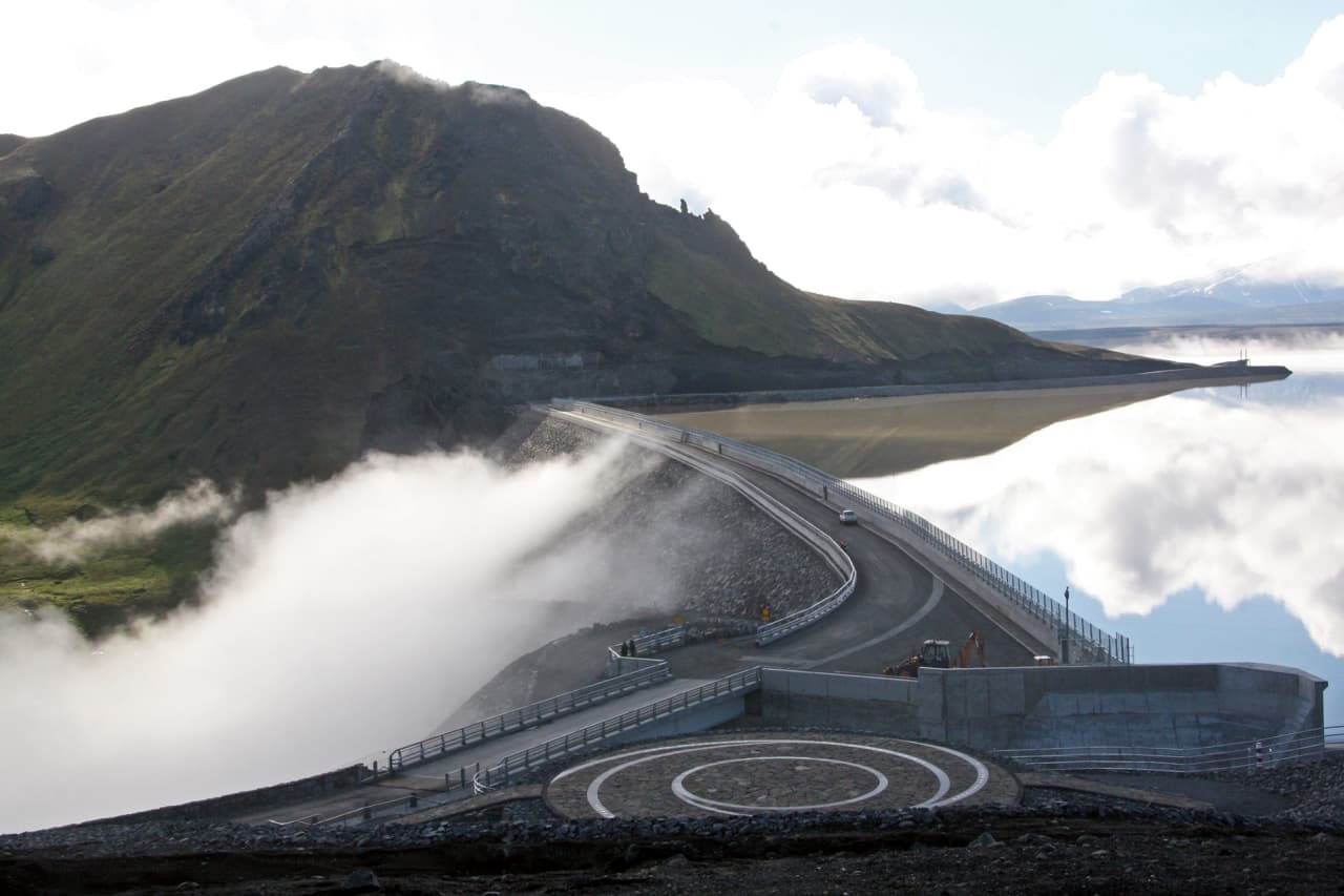
Is Kárahnjúkavirkjun worth the inland detour?

Yes, if your East Iceland route already has time for highland scale, canyon country, and an infrastructure stop that feels very different from fjord towns and roadside waterfalls.

Kárahnjúkavirkjun is strongest when the drive has a clear job. The dam, Hálslón reservoir, spillway, and empty inland setting can make a memorable contrast after Egilsstaðir, Fljótsdalur, or the coast, but they are not worth forcing into a rushed Ring Road transfer.

A local Iceland travel editor would add Kárahnjúkavirkjun for travelers who want to understand the East Iceland highland edge, especially when Snæfell, Fljótsdalur, Hafrahvammagljúfur, or Laugarvalladalur already give the day a purpose. The same editor would cut it when cloud, wind, road uncertainty, or a short itinerary makes Seyðisfjörður, Hengifoss, or easier East Iceland stops a cleaner choice.

Choose the version that fits your day
Visit styleUse it whenWhat to decide
Quick dam stopYou are already driving inland and want the main reservoir and dam view.Allow a short viewpoint visit, then return before the detour expands.
Balanced detourWeather is clear and the route has room for dam, reservoir, and nearby canyon context.Pair Kárahnjúkavirkjun with one nearby highland-edge stop instead of chasing every side road.
Slow inland dayYou have a flexible East Iceland day, suitable vehicle decisions, and a backup plan.Build the day around road, weather, and daylight checks before committing deeper.

Worth the stop?

When this stop makes sense

Good match for

  • East Iceland self-drivers with a slower inland day
  • travelers interested in highland landscapes and hydropower scale
  • photographers who want dam, reservoir, and canyon context
  • visitors pairing Kárahnjúkavirkjun with nearby canyon or mountain stops

Think twice if

  • fast Ring Road trips with no East Iceland buffer
  • travelers who only want easy coastal or town stops

Pair it with

East IcelandSnæfellSeyðisfjörðurIceland Highlands Road Trip Planning

What do you see at the dam and Hálslón?

You see a large engineered landscape: dam walls, railings, a broad reservoir, spillway drama when water is moving, and highland mountains that make the scale feel exposed.

The visit is less about a single natural viewpoint and more about the meeting point between infrastructure and the East Iceland highlands. Hálslón can look calm and reflective, the spillway can feel forceful, and the surrounding terrain reminds you that this is far from the easy coastal rhythm of many Iceland road trips.

The dam also gives context to the wider Jökulsá á Dal area. Travelers often connect the name with Kárahnjúkar, Hafrahvammagljúfur, and the road network toward rougher canyon country. Keep those as related decisions, because the dam viewpoint and the deeper canyon routes do not ask the same effort from the driver.

The dam makes more sense when you see how the reservoir, spillway, and canyon sit together.

If you care about Iceland's interior landscapes, Kárahnjúkavirkjun also helps explain the transition toward Vatnajökull, Snæfell, and the open highland country north of the glacier. If you mainly want classic waterfall, beach, or fjord scenery, the detour can feel too specialized for the time it takes.

How much time should you give Kárahnjúkavirkjun?

Plan the dam itself as a short-to-moderate stop, but plan the inland drive as the real time cost.

For many travelers, 30-60 minutes at the dam viewpoint is enough to understand the place, take photos, and decide whether the detour has earned its space. The visit gets longer only when you deliberately add nearby canyon, reservoir, or highland-road context.

The balanced version is not about standing longer in one spot. It is about choosing one nearby extension that makes sense for your route, then protecting enough time to return calmly. That matters more here than at a low-friction Ring Road waterfall because weather and road choices can change the whole mood of the day.

Hálslón can be the quiet part of the stop when the weather gives you visibility and calm water.
  • Go for the quick version if you only need dam, reservoir, and highland-scale context.
  • Choose the balanced version if conditions support one canyon or mountain pairing.
  • Skip the slow version unless East Iceland is getting a full, flexible inland day.

What should you check before driving inland?

Check official road, weather, safety, and operator visitor information before treating the dam or nearby canyon roads as fixed parts of the plan.

The simplest visitor version is the dam approach from Fljótsdalur. Beyond that, maps can make nearby roads and canyon trailheads look easier than they feel on the ground. Official road conditions, vehicle rules, forecast, daylight, and on-site signs should decide how far you continue.

This is also a dam and reservoir environment, so barriers, signs, and marked viewpoints matter. Do not improvise around edges, spillway areas, or reservoir margins because a photo angle looks tempting. If a facility, tour, road, or access detail matters to your day, verify it through official visitor information before relying on it.

Marked viewpoints and railings are part of the practical visit, not background decoration.

Which nearby places make the detour stronger?

Kárahnjúkavirkjun is strongest when it belongs to a focused East Iceland inland day, not when it is added as one more distant pin.

Snæfell is the best existing comparison if you want a more wilderness-led highland objective. Kárahnjúkavirkjun gives dam, reservoir, and canyon context; Snæfell gives mountain scale, hiking judgment, wildlife habitat, and a stricter access decision.

If the route is more coastal or town-led, Seyðisfjörður may be the better use of energy. It gives a clear fjord-town detour with a different kind of East Iceland payoff, while Kárahnjúkavirkjun asks for more interest in the interior.

For a broader route choice, use the East Iceland region guide to decide whether your trip has room for an inland layer at all. If the answer is yes, Highlands road-trip planning helps frame the vehicle, road, and backup-plan mindset before you extend beyond the simplest dam visit.

The reservoir landscape is part of the reward, but it changes with light, weather, and water level.

Questions that decide the plan

These are the practical questions that usually decide whether Kárahnjúkavirkjun belongs in an East Iceland route.

Can I visit Kárahnjúkavirkjun as a normal East Iceland stop?

Yes, if the route, weather, and official visitor information support the dam approach. Treat rougher nearby roads and canyon trailheads as separate access decisions, not automatic add-ons.

Is Kárahnjúkavirkjun mainly for photographers?

No, but photographers may get the most obvious reward from the dam, reservoir, spillway, and highland scale. Travelers who dislike industrial landscapes may prefer fjord towns, waterfalls, or easier coastal stops.

How long should I allow for the dam?

Allow 30-60 minutes for a focused dam and reservoir stop. Add much more time only if road, weather, vehicle, and daylight checks support a wider canyon or highland plan.

Should I pair it with Hafrahvammagljúfur?

Pairing it with Hafrahvammagljúfur can make sense on a slow, prepared inland day. Check official road and safety guidance first, because the canyon route has a different access profile than the main dam viewpoint.

Official checks before you go