
Places to see
Iceland Attractions
Use this page to find the landmarks, landscapes, and scenic areas worth building your route around.
Useful for
Where to start
Start with a few route-shaping sights.
Use these as quick entry points. The full attraction list is in the searchable results below.

Gullfoss Waterfall
Gullfoss is the Golden Circle waterfall that feels powerful even on a short stop, but it is best planned with viewpoint time, weather, and nearby stops in mind.

Reynisfjara
Reynisfjara is a dramatic South Coast black sand beach near Vík, currently best treated as a viewpoint-first stop because surf, erosion, and warning lights control access.
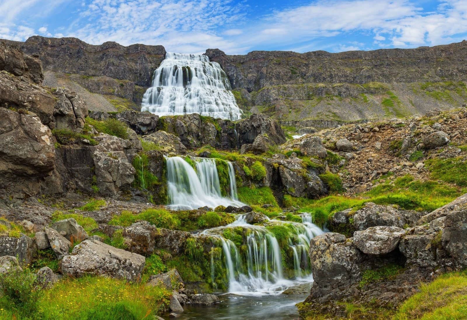
Dynjandi
Dynjandi is the signature Westfjords waterfall, reached by a short uphill walk past smaller cascades to a broad, thunderous main fall.
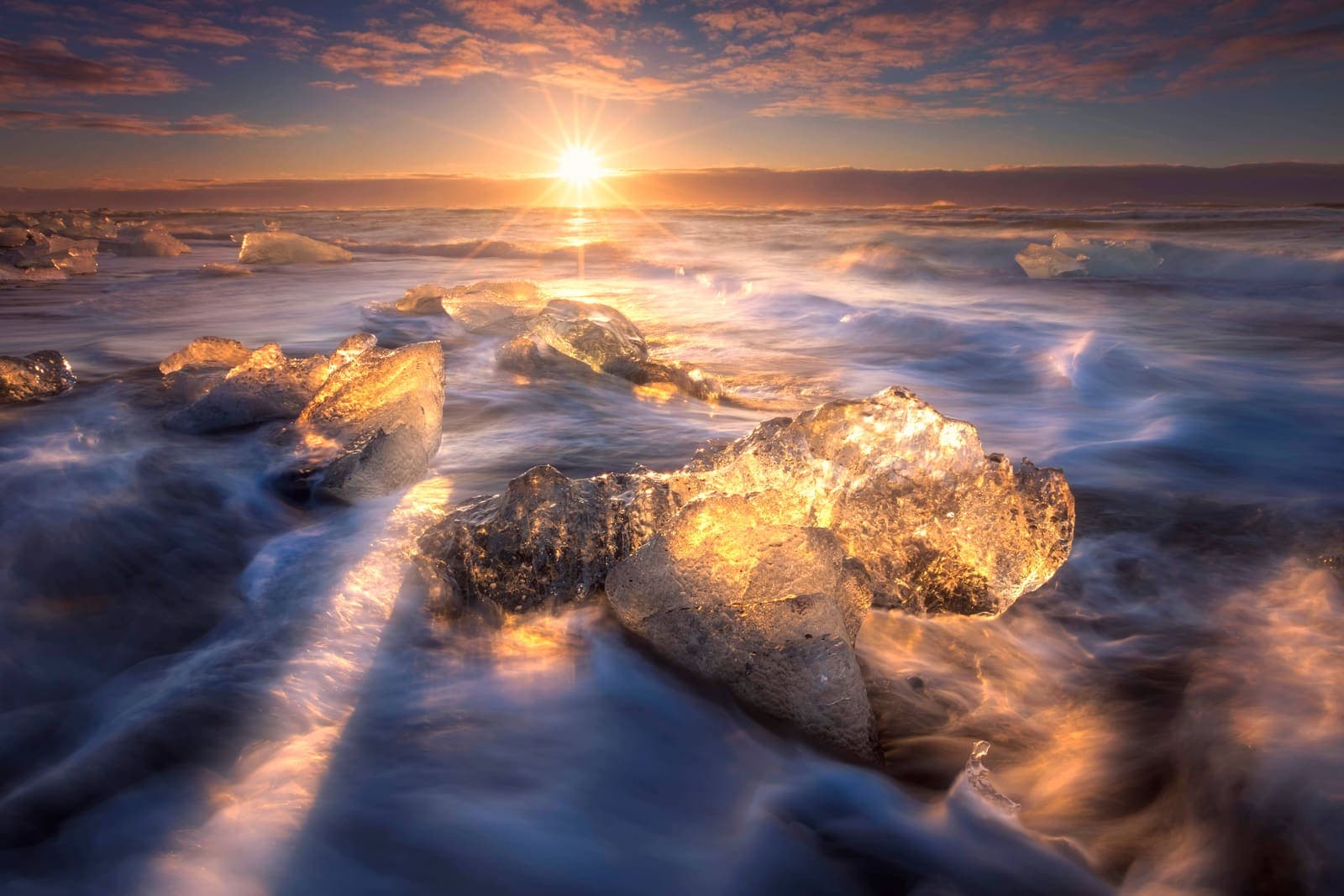
Diamond Beach
Diamond Beach is the black-sand shoreline beside Jökulsárlón where glacier ice can wash ashore, creating one of the South Coast’s most changeable photo stops.

Hallgrímskirkja
Hallgrímskirkja is Reykjavík’s landmark church, with a sculptural exterior, spare interior, large organ, and tower view over the city.

Lóndrangar
Lóndrangar is a pair of basalt sea stacks on the Snæfellsnes coast, best experienced from the marked cliff viewpoints and nearby coastal paths.
All place guides
Find sights worth building into your route.
Search and filter attraction pages and visual collections without mixing in route or region hubs.
What do you want to see?
Where?
Route level
Trip style

Saurbæjarkirkja
Saurbæjarkirkja is a preserved turf church in Eyjafjörður south of Akureyri, best for travelers deciding whether a quiet cultural detour belongs in a North Iceland driving day or should be skipped.
North Iceland · Turf church · Short cultural stop
Hóp Lake
Hóp Lake is a tidal lake and wetland stop in northwestern North Iceland, useful when your day already passes Vatnsdalur, Vatnsnes, or Blönduós and you want a quiet landscape pause.
North Iceland · Tidal lake · Quiet route pause
The Settlement Center
The Settlement Center is a story-led museum in Borgarnes, useful when West Iceland or Snæfellsnes plans need cultural context, an indoor-leaning pause, and enough time to check visitor details before committing.
Museum · Borgarnes · West Iceland
Skriðuklaustur
Skriðuklaustur is a cultural and historic site in Fljótsdalur, East Iceland, where Gunnar Gunnarsson’s turf-roofed house, medieval monastery ruins, and nearby park context make a calm cultural stop worth weighing against drive time.
Fljótsdalur culture stop · Near Egilsstaðir · Gunnarshús and ruins
Skógar
Skógar is a tiny South Coast village beside Skógafoss, useful when you want to turn a famous waterfall stop into a slower cluster with culture, short walks, and route choices.
Village cluster · South Iceland · South Coast
Þórbergssetur
Þórbergssetur is a culture center and heritage museum at Hali in Suðursveit, useful when a glacier-lagoon driving day needs local history, literary context, and a calmer indoor pause near Jökulsárlón.
Hali museum · Near Jökulsárlón · Indoor Ring Road pause
Víti in Krafla
Víti in Krafla is a blue-green maar crater above Lake Mývatn, useful as a short Diamond Circle volcanic stop when road, wind, and rim conditions support more than a quick viewpoint.
North Iceland · Krafla area · Crater lake
Reykir Regional Museum (Hrútafjörður)
Reykir Regional Museum is a small Hrútafjörður cultural stop built around Ófeigur, a shark-fishing boat, farm-life exhibits, and the decision of whether a short museum pause improves a North Iceland drive.
Hrútafjörður · Museum · 30-60 min
Vesturdalur Valley
Vesturdalur Valley is a Jökulsárgljúfur walking area in North Iceland, useful when you want basalt formations, river canyon texture, and enough time to choose a marked trail carefully.
Jökulsárgljúfur · Diamond Circle · Marked walks
Vestragil
Vestragil is a small gully and hot-spring area in Skaftafell, best for travelers who already have time in Vatnajökull National Park and need to decide if a quiet side stop is worth adding.
Skaftafell side stop · 30-75 minutes · Access checks matter
Varmahlíð
Varmahlíð is a small Skagafjörður village on the North Iceland route, useful when you need a practical pause, valley view, or base decision rather than a standalone sightseeing detour.
Skagafjörður village · North Iceland route stop · Ring Road pause · Reykjarhóll views
Ullarfoss
Ullarfoss is a quiet waterfall on the Svartá side of North Iceland, best considered as an optional add-on near Goðafoss and Aldeyjarfoss when walking effort, weather, and route time all make sense.
North Iceland · Waterfall · Quiet add-on
Skútustaðagígar
Skútustaðagígar is a protected group of grassy pseudocraters on the south side of Lake Mývatn, worth adding when you want an easy volcanic walk, birdlife, and a calmer North Iceland stop.
North Iceland · Lake Mývatn · Pseudocraters
Skeiðarársandur
Skeiðarársandur is the vast black-sand outwash plain between Vatnajökull and the Atlantic, best judged as a scenic Route 1 context stop rather than a destination that replaces Skaftafell or Jökulsárlón.
South Coast · Route 1 · Black-sand plain
Lúdentarborgir
Lúdentarborgir is a quiet crater row southeast of Lake Mývatn, useful for geology-minded self-drivers deciding whether a rougher volcanic side stop adds enough context beside easier Mývatn sights.
North Iceland · Crater row · Mývatn side stop
Jökulsárgljúfur
Jökulsárgljúfur is a protected canyon corridor in North Iceland between Dettifoss and Ásbyrgi, worth planning as a Diamond Circle landscape area when you have time for viewpoints, marked walks, and road-condition checks.
North Iceland · Diamond Circle · Canyon corridor
Hverfell
Hverfell is a dark volcanic crater beside Lake Mývatn, best for travelers who want a short climb, wide crater-rim views, and enough flexibility to skip it when wind, ice, or tight timing weakens the stop.
North Iceland · Volcanic crater · Diamond Circle · 45-90 minutes
Hveragerði
Hveragerði is a geothermal town east of Reykjavík, useful as a quick stop, soft overnight base, or Reykjadalur gateway when you decide how much time to give the steam, walks, and nearby routes.
Geothermal town · South Iceland · Golden Circle edge
Hvalfjörður
Hvalfjörður is a broad fjord north of Reykjavík where Route 47 gives self-drive travelers a slower scenic alternative to the tunnel, worth adding when you want quiet viewpoints, Glymur access, and West Iceland context.
West Iceland · Route 47 · Fjord drive
Hengladalsá
Hengladalsá is a small river and valley-area stop in the Hengill landscape near Hveragerði, best considered when you want a quieter geothermal walk rather than another major Golden Circle sight.
River valley · South Iceland · Hengill area
Grjótagjá
Grjótagjá is a small lava cave with blue geothermal water near Lake Mývatn, best as a short, safety-aware stop when you want cave texture without treating it as a bathing place.
Lake Mývatn · Lava cave · Short Diamond Circle stop · No bathing
Fjallsjökull Glacier
Fjallsjökull is an outlet glacier above Fjallsárlón in southeast Iceland, best visited as a glacier-view stop or guided ice experience, not as a casual walk onto the ice.
South Iceland · South Coast · Outlet glacier · 30-60 minutes
Erpsstaðir
Erpsstaðir is a West Iceland dairy farm and creamery near Búðardalur, worth a stop when Route 60 needs a short food-and-farm pause, but easiest to keep flexible until visitor details line up.
Creamery stop · West Iceland · Route 60
Skogafoss
Skogafoss is a powerful South Coast waterfall at Skogar, known for its wide curtain of spray, rainbow views, and stair access to the river above.
Waterfall · South Iceland · South CoastReynisfjara
Reynisfjara is a dramatic South Coast black sand beach near Vík, currently best treated as a viewpoint-first stop because surf, erosion, and warning lights control access.
South Coast black sand beach · Basalt columns and Reynisdrangar sea stacks · Safety-sensitive surf viewpoint · Near Vík, Dyrhólaey, and Skógafoss
Hverir Geothermal Area
Hverir Geothermal Area is a compact, highly active mud-pool and fumarole field beside Route 1 in the Mývatn area of North Iceland.
Mývatn geothermal field · Route 1 stop · North Iceland
Glaumbær
Glaumbær is a turf-house museum in Skagafjörður, where preserved farm buildings, small rooms, and rural objects make North Iceland history tangible.
Skagafjörður turf farm · North Iceland museum · Ring Road culture stop · historic buildings
Dimmuborgir
Dimmuborgir is a protected lava-field labyrinth beside Lake Mývatn, best for an easy but otherworldly walk among arches, caves, and dark rock towers.
North Iceland · Lake Mývatn · Lava formations
Ásbyrgi Canyon
Ásbyrgi is a horseshoe-shaped canyon and birch-filled hollow in North Iceland, best visited as a calm walking stop on the Diamond Circle.
North Iceland · Diamond Circle · Canyon walks
Seljalandsfoss
Seljalandsfoss is a South Coast waterfall famous for its walk-behind path, easy Ring Road access, and nearby Gljúfrabúi pairing.
South Coast waterfall · Walk-behind path when open · Near Gljúfrabúi and Skógafoss · Easy Ring Road accessHvítserkur
Hvítserkur is a basalt sea stack off the Vatnsnes coast in North Iceland, best planned as a short but distinctive detour with viewpoint, beach, and seal-watching context.
North Iceland sea stack · Vatnsnes peninsula · Seal Circle area · Road 711 detour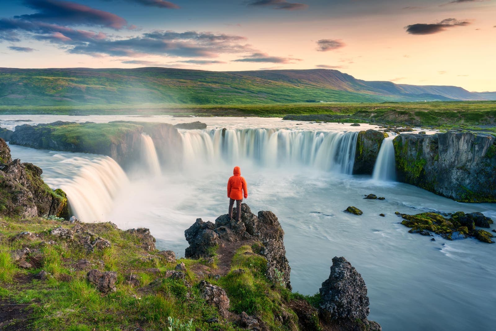
Goðafoss Waterfall
Goðafoss is a wide, horseshoe-shaped waterfall on the Ring Road in North Iceland, easy to pair with Mývatn, Akureyri, or the Diamond Circle.
Waterfall · North Iceland · Ring Road / Diamond Circle
Fjaðrárgljúfur Canyon
Fjaðrárgljúfur Canyon is a narrow moss-lined South Coast gorge near Kirkjubæjarklaustur, with rim viewpoints over the Fjaðrá river.
South Coast canyon · 45-90 minutes · Marked rim viewpoints
Dyrhólaey
Dyrhólaey is a cliff-top South Coast headland near Vík, known for its sea arch, lighthouse, birdlife, and wide views over black-sand beaches.
sea arch · cliff viewpoint · near Vík · South CoastDiamond Beach
Diamond Beach is the black-sand shoreline beside Jökulsárlón where glacier ice can wash ashore, creating one of the South Coast’s most changeable photo stops.
black sand beach · glacier ice · Jökulsárlón pairing · southeast Ring Road
Build a trip around the places you want to see.
Once the sights are clear, use planning pages to turn them into a route with realistic timing.