Dyrhólaey is a South Coast headland near Vík, worth adding for elevated sea-arch, cliff, bird, and black-sand views when weather, access, and nearby Reynisfjara timing work, with enough flexibility for conditions and nearby route choices.
Quick guide
Type
Cliff-top headland, sea arch, lighthouse viewpoint, and protected bird area
Region
South Iceland, just west of Vík and above the Reynisfjara coast
Route context
Best as a South Coast stop between Skógafoss, Reynisfjara, and Vík
Time to allow
About 30-60 minutes for viewpoints; longer if you move slowly between the lower and upper areas
Best experience
Clear weather, good visibility, and enough wind awareness to enjoy the cliffs safely
Season note
Bird nesting can affect access in spring and early summer, so current notices matter
Access reality
Road, weather, and protected-area restrictions can change; verify conditions before committing the detour
Nearby pairings
Reynisfjara, Reynisdrangar, Vík, Skógafoss, and other South Coast stops
Is Dyrhólaey worth the detour on the South Coast?
Yes, Dyrhólaey is worth the detour when visibility is decent and you want one of the South Coast’s strongest cliff viewpoints. It is less rewarding when low cloud, wind, nesting restrictions, or a rushed itinerary turn the stop into a quick parking-lot photo.
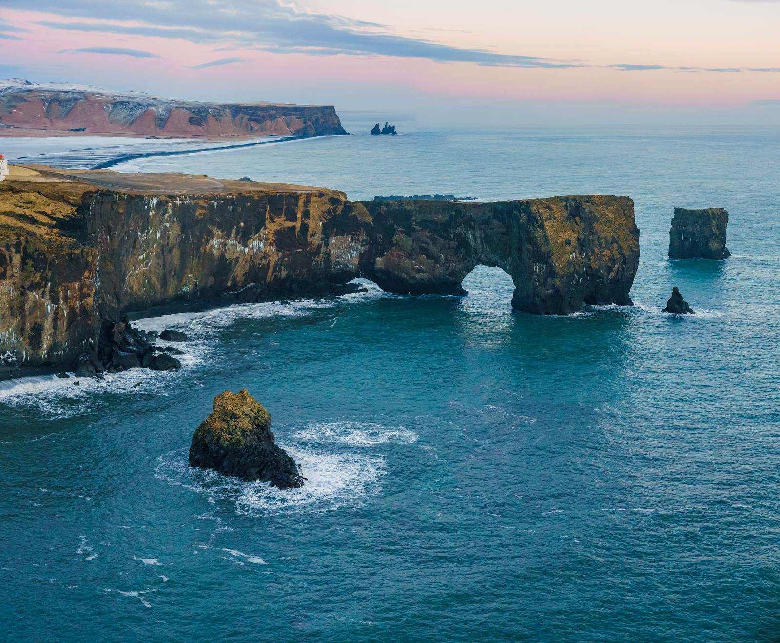
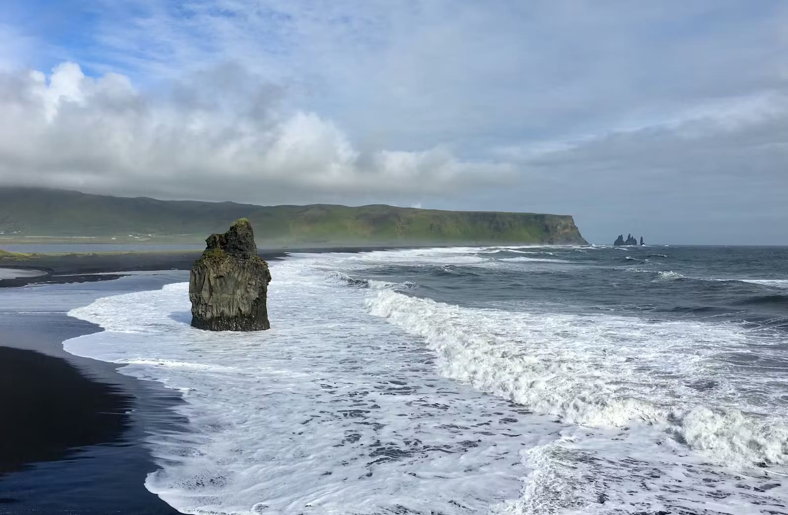
The headland gives you a different perspective from the beach stops below it. Instead of standing beside the surf, you look over black sand, sea stacks, cliff faces, and the natural arch that gives Dyrhólaey its identity.
For most travelers, the best plan is simple: add Dyrhólaey near Reynisfjara and Vík, but keep it flexible until you know the day’s weather and access situation. If the sky is low or the wind is uncomfortable, Skógafoss, Vík, or a shorter South Coast cluster may be the better use of time.
Worth the stop?
When this stop makes sense
Good match for
South Coast self-drive travelers
cliff and sea-arch views
photographers in clear weather
birdlife watchers in season
Think twice if
travelers uncomfortable near exposed cliff edges
tight winter days with poor visibility or strong wind
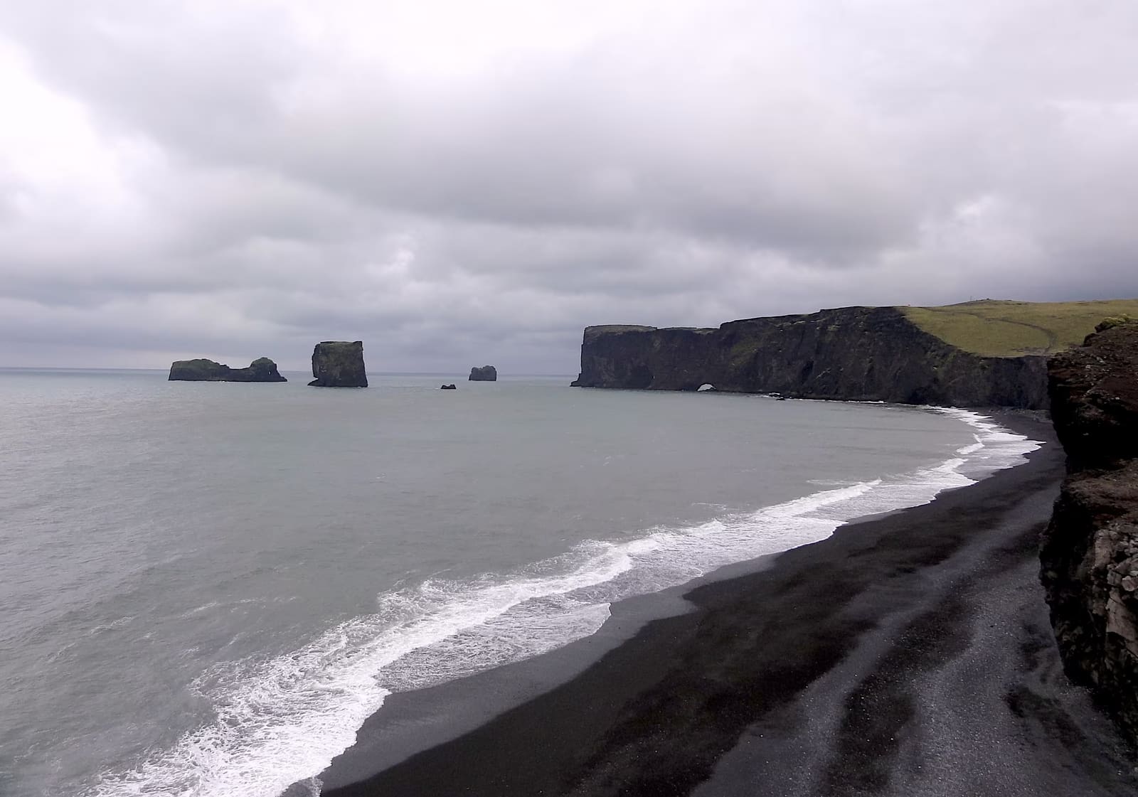
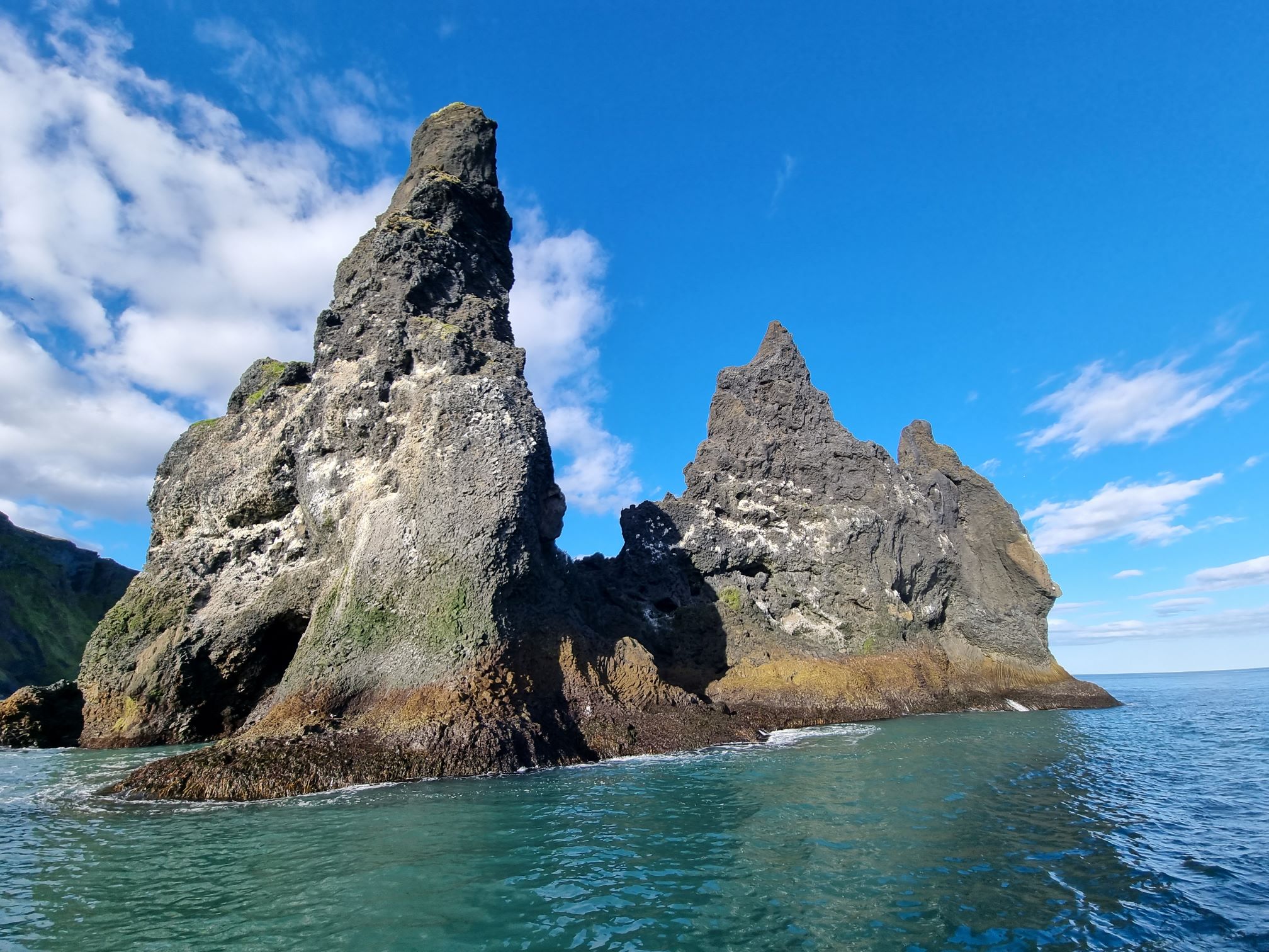
Dyrhólaey is mainly about scale. From the viewpoints, the coast opens in long horizontal lines: dark beach, pale surf, offshore stacks, a broad headland, and the arch cut through the rock.
The most recognizable view is the sea arch itself, but the wider scene is often what makes the stop memorable. On a clear day you can read the whole coastline around Reynisfjara and Reynisdrangar from above, which helps explain why this area feels so different from the waterfall stops farther west.
The cliff-top view is the main reason to add Dyrhólaey to a South Coast day.
The visit is not complicated, but it is exposed. Wind can make the cliffs feel more serious than the map suggests, and the best photos often tempt people toward edges. Keep the viewpoint experience conservative rather than trying to turn it into an unmarked scramble.
Sea arch, lighthouse, and birdlife: how the visit usually feels
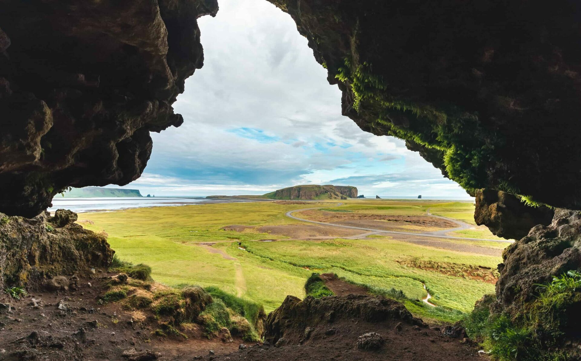
A good Dyrhólaey stop has three layers: the cliff and arch views, the lighthouse area above the headland, and seasonal birdlife on the protected cliffs.
The lighthouse gives the upper area a clear landmark, while the cliffs and offshore rocks carry the visual weight. In spring and summer, many visitors also hope to see puffins and other seabirds, but birdlife should be treated as a bonus rather than a guaranteed show.
The arch is the signature view, but the surrounding cliffs and stacks are part of the same scene.
Because the area is protected, visitor behavior matters. Stay on marked or obvious visitor areas, respect closures, and give nesting birds space. If access is limited, do not try to replace the closed view with a fragile cliff-edge alternative.
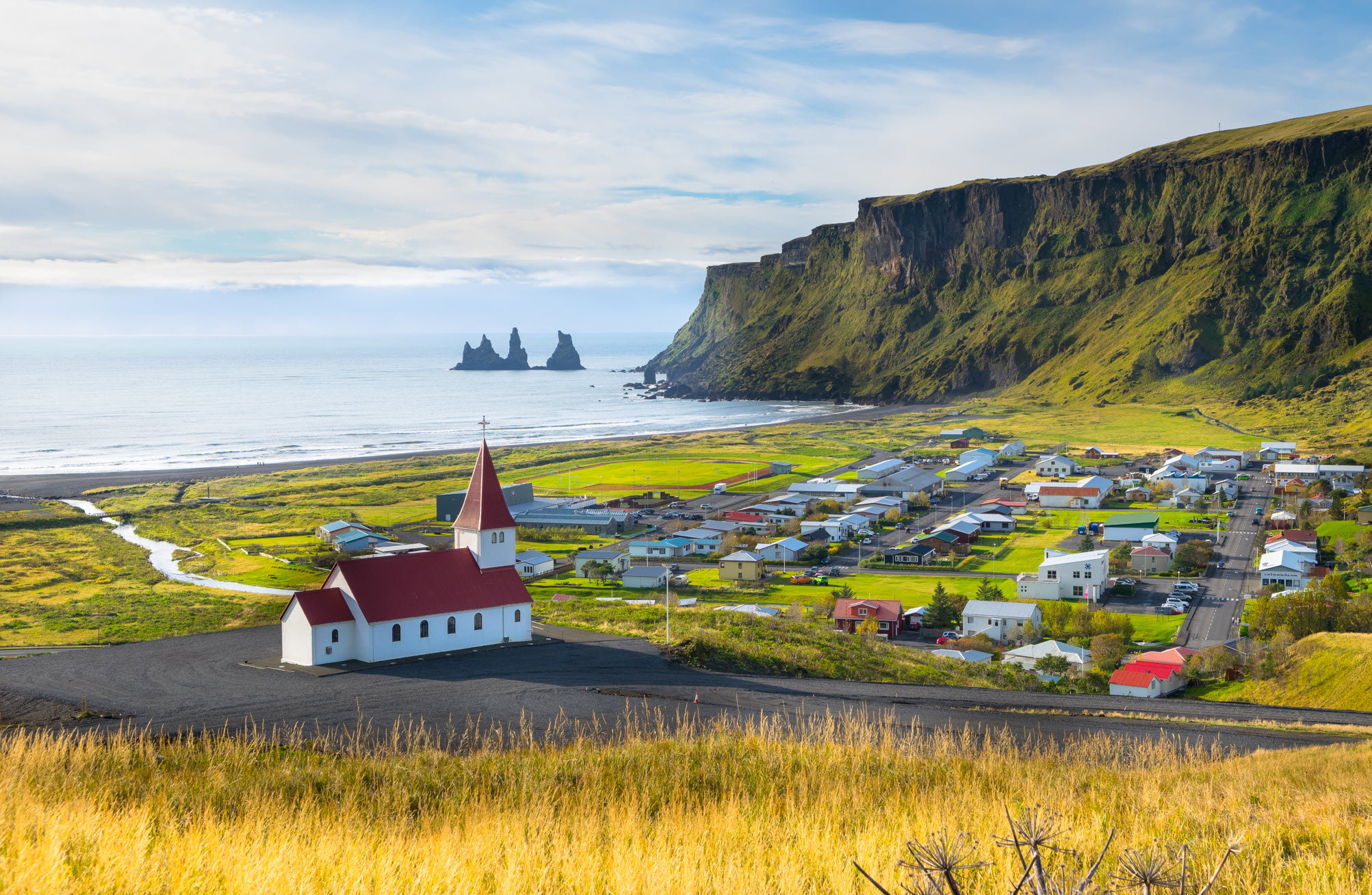
How to pair Dyrhólaey with Reynisfjara and Vík
Dyrhólaey pairs naturally with Reynisfjara and Vík because all three sit around the same coastal pocket, but they do different jobs in the day.
Use Dyrhólaey for the elevated view, Reynisfjara for the beach-level basalt and surf, and Vík for food, fuel, weather decisions, and a practical pause. This keeps the area from becoming a repetitive black-sand checklist.
If you are driving the South Coast from Reykjavík, Dyrhólaey usually makes more sense after the western waterfall stops and before or after Reynisfjara, depending on light, weather, and how much time you want near Vík. On a longer Ring Road trip, it can be a high-value stop before continuing east.
Dyrhólaey adds cliff and headland views to the Reynisfjara and Vík coastal cluster.
Access, safety, and current checks before you go
The main planning risk is not distance; it is conditions. Dyrhólaey is close to major South Coast stops, but wind, road status, protected-area management, and nearby beach hazards can change how sensible the stop feels.
Check official protected-area information before visiting, especially in the nesting season. Also check road conditions and weather if you are visiting in winter, during storms, or on a day when the upper road may be uncomfortable.
Do not let the cliff stop blur into unsafe beach behavior. Nearby black-sand beaches can have powerful sneaker waves, and SafeTravel’s black beach guidance is worth reading before you build this whole coastal pocket into the day.
Use before visiting Reynisfjara or other nearby black-sand beaches.
Common Dyrhólaey planning questions
Most uncertainty around Dyrhólaey comes from access, timing, birds, and whether it duplicates Reynisfjara.
Light can make Dyrhólaey spectacular, but visibility and wind still decide how useful the stop feels.
Can you visit Dyrhólaey and Reynisfjara on the same day?
Yes, Dyrhólaey and Reynisfjara fit well on the same South Coast day if weather, daylight, and beach-safety checks are acceptable. Use Dyrhólaey for the elevated view and Reynisfjara for the beach-level basalt and surf.
How long should I spend at Dyrhólaey?
Most travelers should allow about 30-60 minutes at Dyrhólaey. Add more time if you want both the upper lighthouse area and lower viewpoints, or if wind and road conditions slow the visit.
Are puffins guaranteed at Dyrhólaey?
No, puffins are not guaranteed at Dyrhólaey. They are seasonal seabirds, and access can also be limited to protect nesting birds, so treat sightings as a bonus.
Is Dyrhólaey safe in winter?
Dyrhólaey can be reasonable in winter when roads, wind, visibility, and access are good. Check official road and weather sources first, and skip exposed viewpoints if conditions feel uncomfortable.
Map
See where this stop sits
Use nearby places and useful bases before opening directions.
Region
South Iceland
Works well with
South Coast / Ring Road
Useful base
Vík
Interactive planning map for Dyrholaey
Dyrholaey
Keep exploring
Put this place in route context
Use nearby places and planning pages to decide whether this stop strengthens the route or stays optional.