
Places to see
Iceland Attractions
Use this page to find the landmarks, landscapes, and scenic areas worth building your route around.
Useful for
Where to start
Start with a few route-shaping sights.
Use these as quick entry points. The full attraction list is in the searchable results below.

Gullfoss Waterfall
Gullfoss is the Golden Circle waterfall that feels powerful even on a short stop, but it is best planned with viewpoint time, weather, and nearby stops in mind.

Reynisfjara
Reynisfjara is a dramatic South Coast black sand beach near Vík, currently best treated as a viewpoint-first stop because surf, erosion, and warning lights control access.
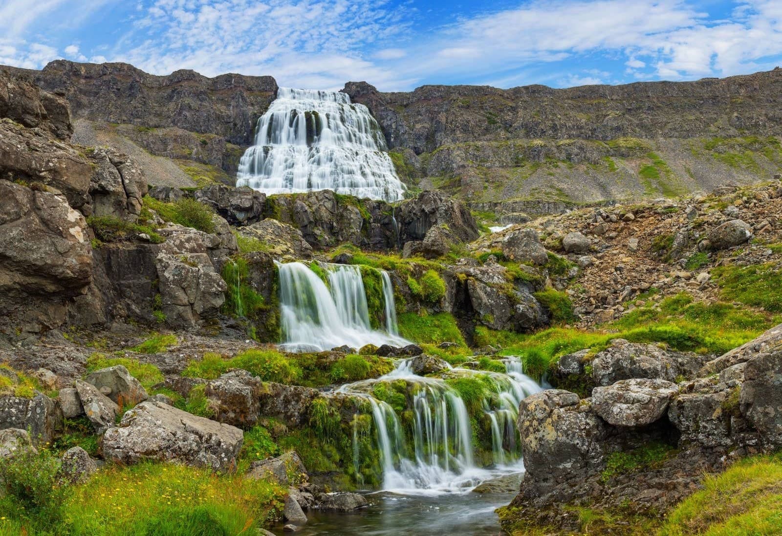
Dynjandi
Dynjandi is the signature Westfjords waterfall, reached by a short uphill walk past smaller cascades to a broad, thunderous main fall.
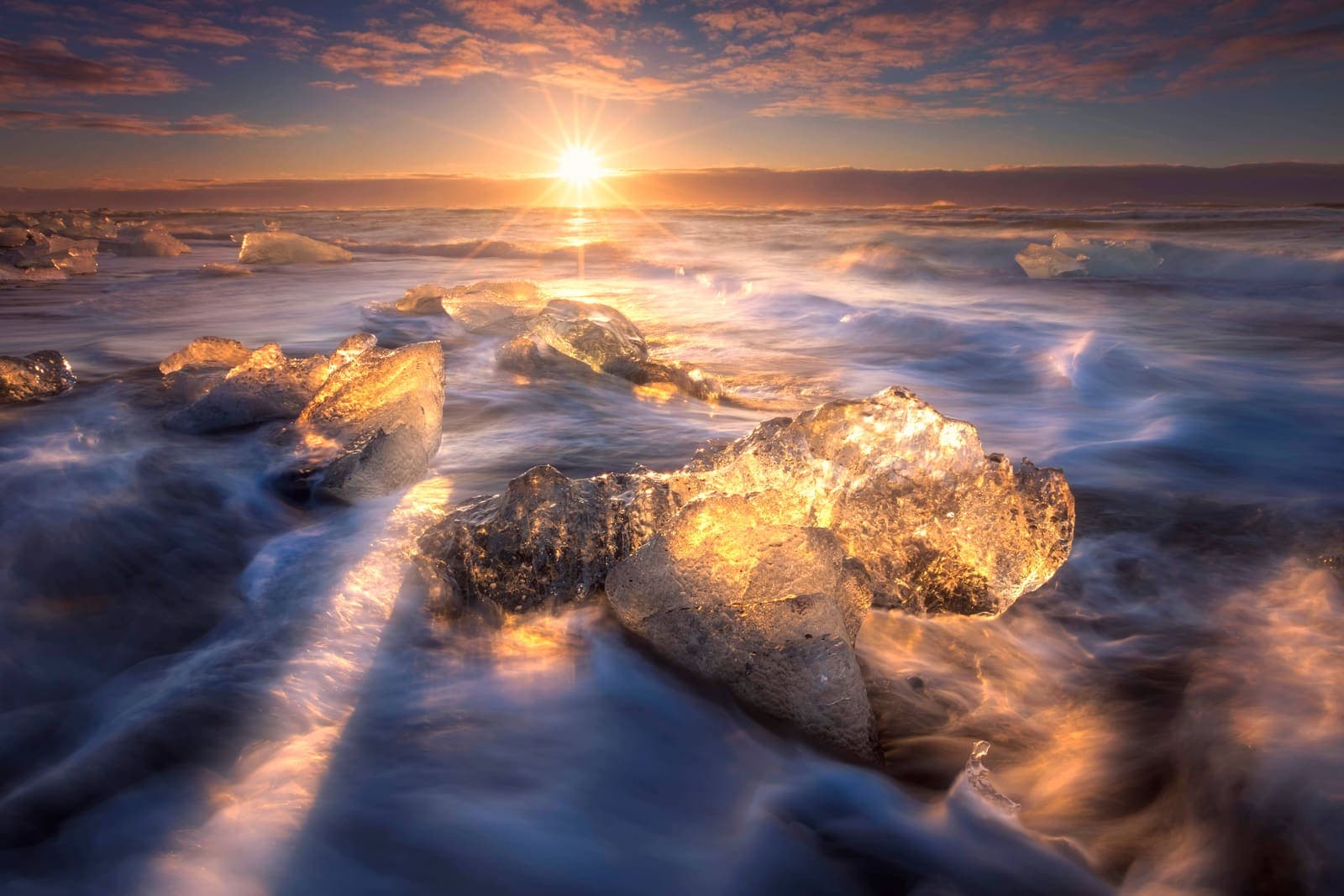
Diamond Beach
Diamond Beach is the black-sand shoreline beside Jökulsárlón where glacier ice can wash ashore, creating one of the South Coast’s most changeable photo stops.

Hallgrímskirkja
Hallgrímskirkja is Reykjavík’s landmark church, with a sculptural exterior, spare interior, large organ, and tower view over the city.

Lóndrangar
Lóndrangar is a pair of basalt sea stacks on the Snæfellsnes coast, best experienced from the marked cliff viewpoints and nearby coastal paths.
All place guides
Find sights worth building into your route.
Search and filter attraction pages and visual collections without mixing in route or region hubs.
What do you want to see?
Where?
Route level
Trip style
Hrepphólar
Hrepphólar is a small basalt-column and church stop near Flúðir in South Iceland, worth adding only when your Golden Circle day has room for a quiet countryside detour between major sights.
Basalt columns · Golden Circle · South Iceland
Þjórsá
Þjórsá is Iceland's longest river and a South Iceland route corridor, useful when you choose a specific waterfall, valley, or river viewpoint instead of treating it as one simple stop.
South Iceland · River corridor · Self-drive decision
Þorlákshöfn
Þorlákshöfn is a harbor town on South Iceland's southwest coast, useful when you want a quieter coastal pause, ferry-contingency context, or Lighthouse Trail stop before deciding whether the detour strengthens your day.
Harbor town · South Iceland · Coastal pause
Þingvallavatn
Þingvallavatn is the broad lake beside Þingvellir on the Golden Circle, useful when you want landscape scale, rift-water context, or a quieter pause beyond the main park paths.
Golden Circle · Lake and rift landscape · Þingvellir context
Sólheimasandur
Sólheimasandur is an exposed black-sand outwash plain on Iceland's South Coast, known for the DC-3 plane wreck; visit only if the long walk, weather, and daylight strengthen rather than crowd your route.
South Coast black sand · DC-3 wreck walk · Weather-sensitive stop · Near Skógar and Vík
Sólheimajökull Glacier
Sólheimajökull is an accessible South Coast glacier tongue where travelers can view Mýrdalsjökull ice up close, then decide whether a guided glacier walk is worth the time, cost, and safety checks.
South Coast glacier · Viewpoint or guided hike · Near Skógar and Vík · Road 221 access check
Skjaldbreiður
Skjaldbreiður is a broad shield volcano north of Þingvellir, best for prepared self-drive travelers deciding whether highland-edge scenery and geology justify extra time beyond the classic Golden Circle stops.
Shield volcano · Near Þingvellir · Golden Circle extension · Road-sensitive detour
Skeiðarársandur
Skeiðarársandur is the vast black-sand outwash plain between Vatnajökull and the Atlantic, best judged as a scenic Route 1 context stop rather than a destination that replaces Skaftafell or Jökulsárlón.
South Coast · Route 1 · Black-sand plain
Silfra
Silfra is the clear-water fissure inside Þingvellir National Park, best for travelers who want a guided cold-water snorkel or dive and can let that activity shape a Golden Circle day.
South Iceland · Golden Circle · Guided cold-water activity
Nesjavellir
Nesjavellir is a geothermal power-station landscape north of Hengill, useful for self-drivers who want Road 435 views, steam, mountain scale, and a quieter Golden Circle detour with condition checks.
Geothermal area · Near Hengill · Road 435 detour
Klettshellir
Klettshellir is a large sea cave beneath Ystiklettur in the Westman Islands, worth planning only when a boat trip, sea conditions, ferry timing, and island-day priorities all make sense.
Westman Islands · Sea cave · Boat access
Hengladalsá
Hengladalsá is a small river and valley-area stop in the Hengill landscape near Hveragerði, best considered when you want a quieter geothermal walk rather than another major Golden Circle sight.
River valley · South Iceland · Hengill area
Fljótshlíð
Fljótshlíð is a rural saga landscape east of Hvolsvöllur in South Iceland, best for travelers deciding whether a quieter side-road detour adds more than another major waterfall stop.
South Iceland · Saga landscape · Slow detour
Fjallsjökull Glacier
Fjallsjökull is an outlet glacier above Fjallsárlón in southeast Iceland, best visited as a glacier-view stop or guided ice experience, not as a casual walk onto the ice.
South Iceland · South Coast · Outlet glacier · 30-60 minutes
Eldfell
Eldfell is the young red volcano above Heimaey in the Westman Islands, worth adding when you want a short hike, eruption history, and views that justify the ferry time.
Volcano hike · Westman Islands · 1973 eruption · South Coast add-on
Almannagjá
Almannagjá is the main rift walk inside Þingvellir National Park, where the Golden Circle stop becomes more than a viewpoint if you allow time for cliffs, history, and nearby paths.
Golden Circle · Rift walk · 30-90 minutes
Háifoss
Háifoss is a high canyon waterfall in Þjórsárdalur, best planned as a deliberate rough-road detour from the Golden Circle rather than a quick roadside stop.
South Iceland · Canyon waterfall · Golden Circle extension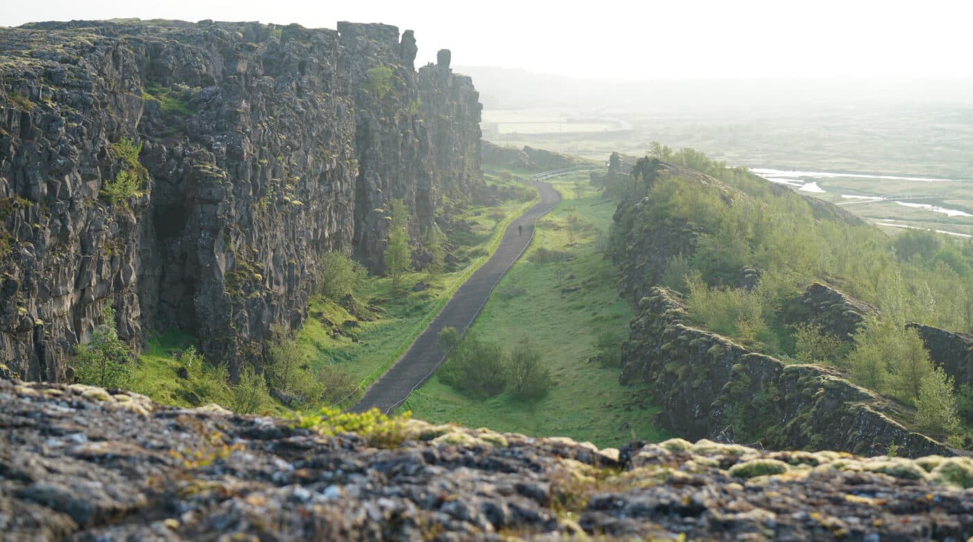
Þingvellir National Park
Þingvellir is the Golden Circle national park where Iceland's parliament history, rift-valley walking, and Lake Þingvallavatn scenery meet. Visit if you can give it more than a photo stop.
Golden Circle · National park · History and rift valley
Skaftafell
Skaftafell is the main walking and glacier-viewing base in southeast Iceland, with marked trails, visitor services, and access to Vatnajökull landscapes.
South Coast hiking base · Vatnajökull National Park · glacier views · marked trailsReynisfjara
Reynisfjara is a dramatic South Coast black sand beach near Vík, currently best treated as a viewpoint-first stop because surf, erosion, and warning lights control access.
South Coast black sand beach · Basalt columns and Reynisdrangar sea stacks · Safety-sensitive surf viewpoint · Near Vík, Dyrhólaey, and Skógafoss
Langisjór
Langisjór is a remote Highlands lake southwest of Vatnajökull, best for summer travelers with the right 4x4, weather window, and time for a slow detour.
Southern Highlands · Remote lake · Summer F-road detour
Jökulsárlón Glacier Lagoon
Jökulsárlón Glacier Lagoon is a Route 1 glacier-lagoon stop in southeast Iceland, best planned with Diamond Beach, current conditions, and enough time to slow down.
South Coast · Ring Road · Glacier lagoon
Hvítá River
Hvítá is the glacial river behind Gullfoss and Brúarhlöð, best planned as a Golden Circle river corridor rather than one single roadside stop.
Golden Circle river · Gullfoss source · Brúarhlöð gorge · glacial water
Seljalandsfoss
Seljalandsfoss is a South Coast waterfall famous for its walk-behind path, easy Ring Road access, and nearby Gljúfrabúi pairing.
South Coast waterfall · Walk-behind path when open · Near Gljúfrabúi and Skógafoss · Easy Ring Road access
Kerið Crater
Kerið is a compact volcanic crater lake on the Golden Circle, best for a short rim walk, lake view, and easy self-drive stop between larger sights.
Golden Circle crater lake · short scenic stop · rim and lake walk · Route 35 accessGullfoss Waterfall
Gullfoss is the Golden Circle waterfall that feels powerful even on a short stop, but it is best planned with viewpoint time, weather, and nearby stops in mind.
Waterfall · Golden Circle · South Iceland
Dyrhólaey
Dyrhólaey is a cliff-top South Coast headland near Vík, known for its sea arch, lighthouse, birdlife, and wide views over black-sand beaches.
sea arch · cliff viewpoint · near Vík · South Coast
Build a trip around the places you want to see.
Once the sights are clear, use planning pages to turn them into a route with realistic timing.