
Places to see
Iceland Attractions
Use this page to find the landmarks, landscapes, and scenic areas worth building your route around.
Useful for
Where to start
Start with a few route-shaping sights.
Use these as quick entry points. The full attraction list is in the searchable results below.

Gullfoss Waterfall
Gullfoss is the Golden Circle waterfall that feels powerful even on a short stop, but it is best planned with viewpoint time, weather, and nearby stops in mind.

Reynisfjara
Reynisfjara is a dramatic South Coast black sand beach near Vík, currently best treated as a viewpoint-first stop because surf, erosion, and warning lights control access.
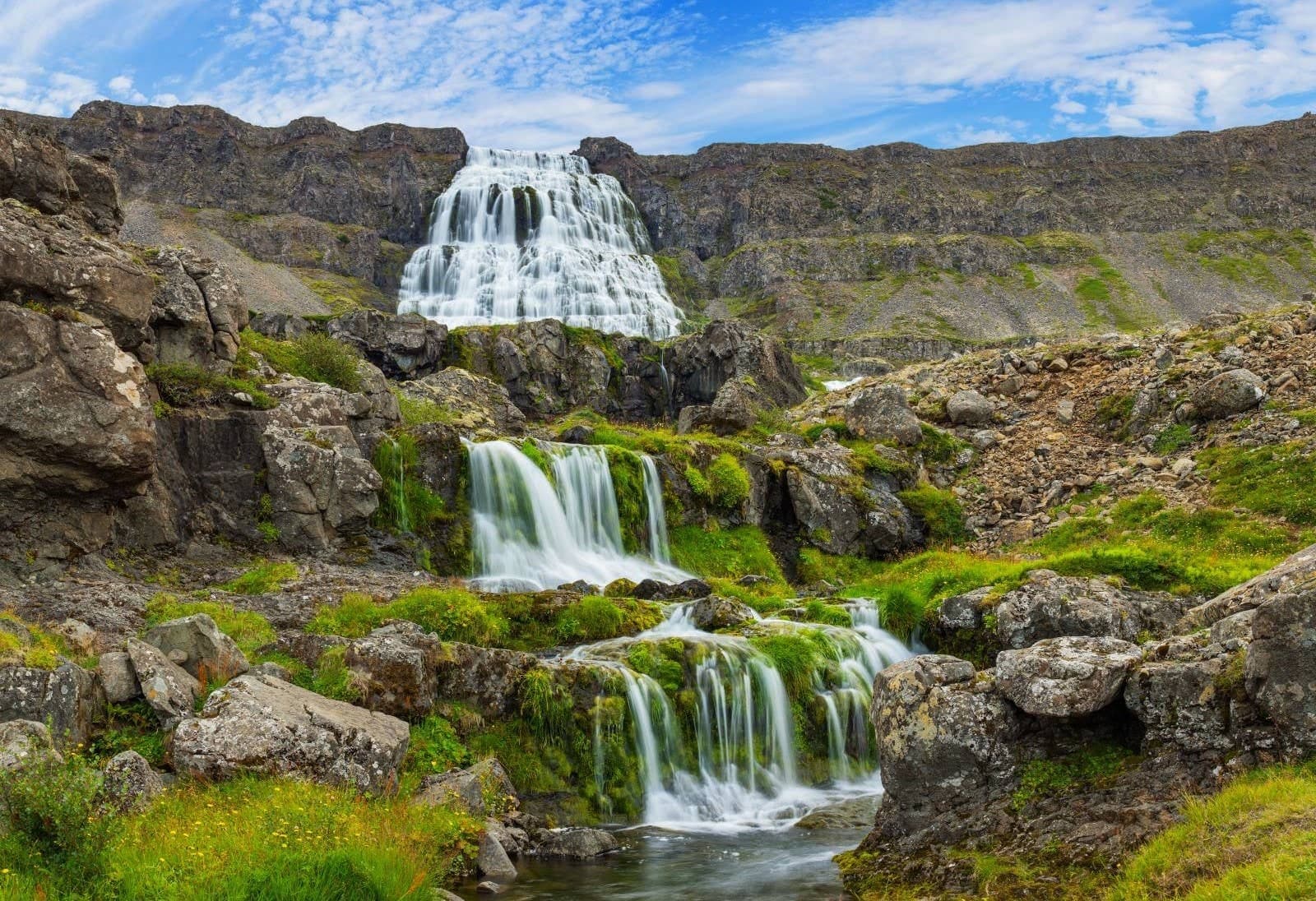
Dynjandi
Dynjandi is the signature Westfjords waterfall, reached by a short uphill walk past smaller cascades to a broad, thunderous main fall.
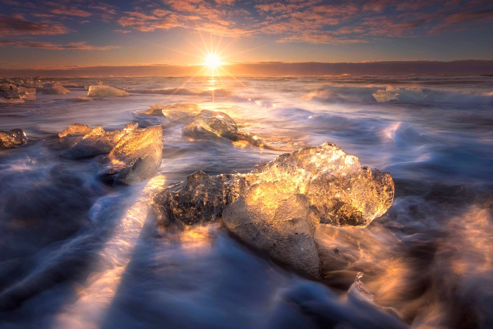
Diamond Beach
Diamond Beach is the black-sand shoreline beside Jökulsárlón where glacier ice can wash ashore, creating one of the South Coast’s most changeable photo stops.

Hallgrímskirkja
Hallgrímskirkja is Reykjavík’s landmark church, with a sculptural exterior, spare interior, large organ, and tower view over the city.

Lóndrangar
Lóndrangar is a pair of basalt sea stacks on the Snæfellsnes coast, best experienced from the marked cliff viewpoints and nearby coastal paths.
All place guides
Find sights worth building into your route.
Search and filter attraction pages and visual collections without mixing in route or region hubs.
What do you want to see?
Where?
Route level
Trip style

Hóp Lake
Hóp Lake is a tidal lake and wetland stop in northwestern North Iceland, useful when your day already passes Vatnsdalur, Vatnsnes, or Blönduós and you want a quiet landscape pause.
North Iceland · Tidal lake · Quiet route pause
Eyjabakkar
Eyjabakkar is a remote East Iceland wetland near Snæfell and Vatnajökull, worth planning only when birdlife, highland scale, flexible access checks, and a slower inland route strengthen your trip.
East Iceland wetland · Highland detour · Birdlife and Snæfell
Stykkishólmur
Stykkishólmur is a compact harbor town on north Snæfellsnes, useful for travelers deciding whether to make a quick scenic stop, slow down overnight, or use the ferry link toward Breiðafjörður and the Westfjords.
Harbor town · North Snæfellsnes base · Breiðafjörður views · Ferry gateway
Strýtur
Strýtur is a protected underwater geothermal chimney field in Eyjafjörður, North Iceland, worth planning only for qualified divers or geology-focused travelers who can build the visit around operator, weather, road, and sea-condition checks.
North Iceland · Underwater geothermal site · Specialist access
Skútustaðagígar
Skútustaðagígar is a protected group of grassy pseudocraters on the south side of Lake Mývatn, worth adding when you want an easy volcanic walk, birdlife, and a calmer North Iceland stop.
North Iceland · Lake Mývatn · Pseudocraters
Öxarfjörður
Öxarfjörður is a wide North Iceland fjord between Tjörnes and Melrakkaslétta, best for travelers deciding whether the quiet coast deserves time between Húsavík, Ásbyrgi, Dettifoss, and the Arctic Coast Way.
North Iceland fjord area · Kópasker and Hringsbjarg views · Near Ásbyrgi and Dettifoss · Best for slower self-drive days
Lundey
Lundey is a small protected bird island in Kollafjörður near Reykjavík, best considered when you want a short boat-based wildlife add-on rather than another city landmark or self-drive stop.
Reykjavík · Wildlife spot · Boat-based short stop
Herðubreiðarlindir
Herðubreiðarlindir is a spring-fed oasis below Herðubreið, reached by F88 in the North Iceland Highlands. It rewards prepared drivers with water, vegetation, lava textures, and quiet walks, but only when road, weather, and day planning leave a real margin.
F88 highland oasis · Herðubreið views · Askja route pause
Elliðaá
Elliðaá is Reykjavík’s salmon river and green-valley corridor, useful when you want an easy nature walk inside the capital instead of another downtown landmark or a long day-trip detour.
Reykjavík · River walk · City nature
Eldey
Eldey is a protected offshore bird island southwest of the Reykjanes Peninsula, useful for travelers who want a clear-weather coastal viewpoint, gannet context, and a realistic add-on near Reykjanesviti rather than a landing visit.
Reykjanes Peninsula · Protected bird island · Clear-weather viewpoint
Þjórsárver
Þjórsárver is a protected wetland oasis in Iceland's central Highlands, worth considering only when your route, vehicle, weather margin, and respect for nesting-sensitive terrain make a remote stop sensible.
Highlands · Protected wetland · Remote access
Surtsey
Surtsey is a protected volcanic island south of the Westman Islands, best treated as a place to understand or view from afar because public landing is prohibited and current sea conditions shape any distant viewing plan.
Protected island · UNESCO site · Westman Islands · View from afar
Heiðmörk
Heiðmörk is Reykjavík’s large forest, lava, and lake-edge recreation area, worth adding when you want easy nature near the city and can choose the right sub-area for your time.
Reykjavík green belt · forest + lava · easy nature break
Breiðafjörður
Breiðafjörður is the island-filled bay between Snæfellsnes and the Westfjords, best for travelers deciding whether a ferry crossing, Flatey stop, wildlife cruise, or slower coastal detour belongs in their route.
Westfjords bay · Ferry and island route · Flatey / birdlife · Westfjords Way
Látrabjarg
Látrabjarg is a remote Westfjords bird cliff at Iceland’s western edge, worth visiting when summer wildlife, safe cliff behavior, and the gravel-road approach fit your route with enough daylight.
Bird cliffs · Westfjords · Westfjords Way
Hornstrandir
Hornstrandir is a remote Westfjords nature reserve reached mainly by boat, best for travelers who want wild cliffs, foxes, and hiking enough to accept weather, camping, and access planning.
Remote Westfjords reserve · Boat access only · Summer hiking and wildlife · High planning effort
Tjörnes Peninsula
Tjörnes is a coastal peninsula north of Húsavík where fossil layers, bird cliffs, sea views, and quiet roads make sense on slower Diamond Circle days.
North Iceland coastal peninsula · Fossil layers and bird cliffs · Between Húsavík and Ásbyrgi · Best on slower Diamond Circle days
Lake Mývatn
Lake Mývatn is North Iceland’s volcanic lake district, where shallow wetlands, pseudocraters, lava formations, geothermal areas, and birdlife sit close together.
North Iceland lake district · Diamond Circle anchor · volcanic and wetland cluster · birdlife and geothermal stops
Vatnsnes
Vatnsnes is a quiet North Iceland peninsula where seal-watching stops, farm coast, Hvítserkur, and slower Arctic Coast Way driving come together.
North Iceland · Seals and sea stack · Half-day detour
Snæfell
Snæfell is a remote East Iceland mountain in Vatnajökull National Park, best planned as a serious summer highland detour rather than a casual roadside stop.
East Iceland highlands · Challenging hike · Summer access
Rauðasandur Beach
Rauðasandur is a remote red-gold beach in the southern Westfjords, best for slow travelers who can give the gravel-road approach and wide tidal flats real time.
Westfjords beach · Road 614 detour · red-gold sand · slow self-drive stopHvítserkur
Hvítserkur is a basalt sea stack off the Vatnsnes coast in North Iceland, best planned as a short but distinctive detour with viewpoint, beach, and seal-watching context.
North Iceland sea stack · Vatnsnes peninsula · Seal Circle area · Road 711 detour
Build a trip around the places you want to see.
Once the sights are clear, use planning pages to turn them into a route with realistic timing.