
Places to see
Iceland Attractions
Use this page to find the landmarks, landscapes, and scenic areas worth building your route around.
Useful for
Where to start
Start with a few route-shaping sights.
Use these as quick entry points. The full attraction list is in the searchable results below.

Gullfoss Waterfall
Gullfoss is the Golden Circle waterfall that feels powerful even on a short stop, but it is best planned with viewpoint time, weather, and nearby stops in mind.

Reynisfjara
Reynisfjara is a dramatic South Coast black sand beach near Vík, currently best treated as a viewpoint-first stop because surf, erosion, and warning lights control access.
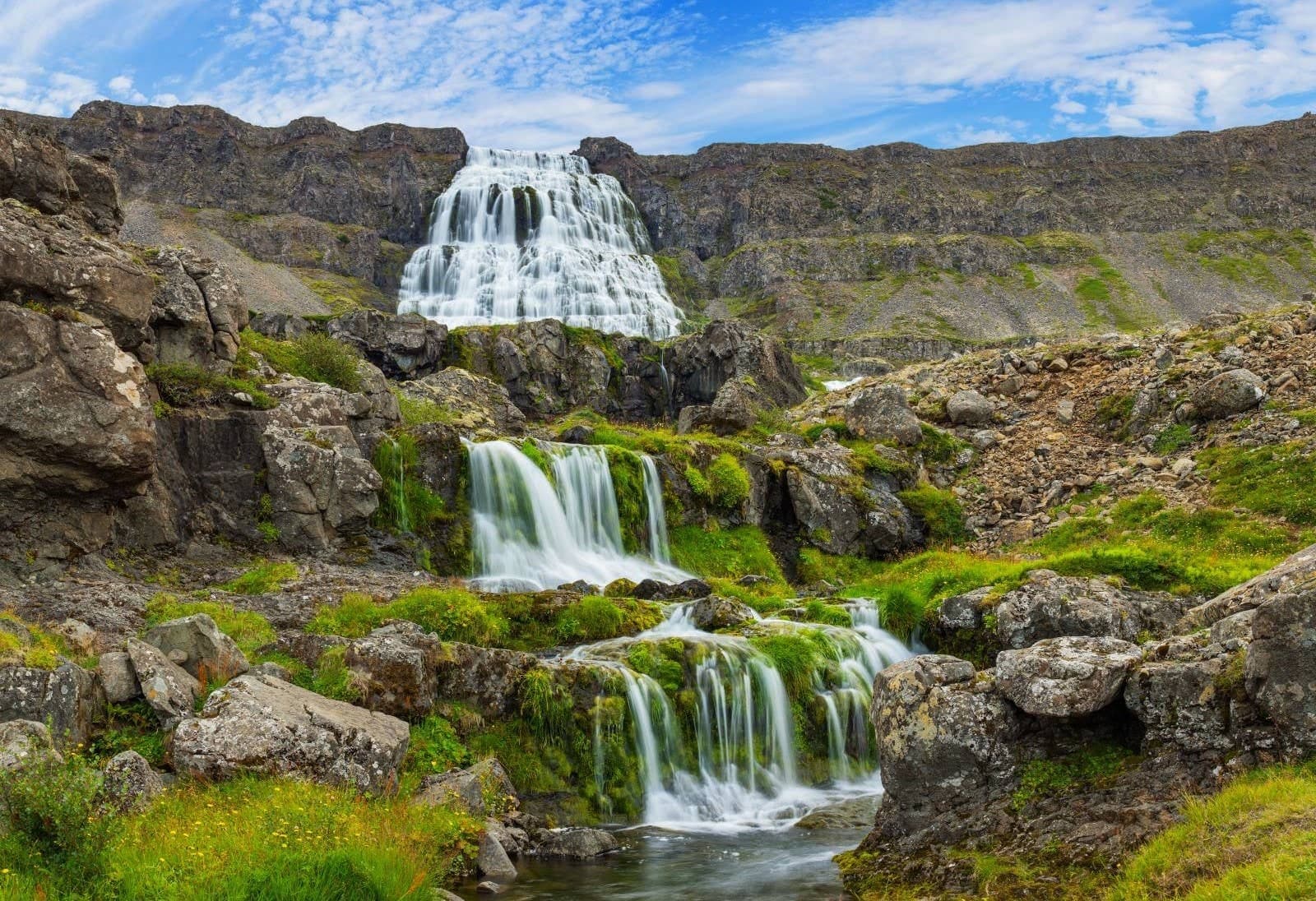
Dynjandi
Dynjandi is the signature Westfjords waterfall, reached by a short uphill walk past smaller cascades to a broad, thunderous main fall.
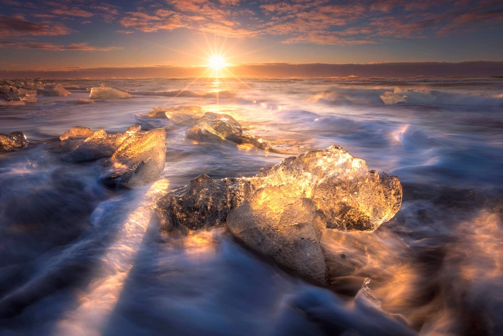
Diamond Beach
Diamond Beach is the black-sand shoreline beside Jökulsárlón where glacier ice can wash ashore, creating one of the South Coast’s most changeable photo stops.

Hallgrímskirkja
Hallgrímskirkja is Reykjavík’s landmark church, with a sculptural exterior, spare interior, large organ, and tower view over the city.

Lóndrangar
Lóndrangar is a pair of basalt sea stacks on the Snæfellsnes coast, best experienced from the marked cliff viewpoints and nearby coastal paths.
All place guides
Find sights worth building into your route.
Search and filter attraction pages and visual collections without mixing in route or region hubs.
What do you want to see?
Where?
Route level
Trip style

Tindfjallajökull
Tindfjallajökull is a remote glacier-capped volcano above South Iceland’s highland edge, worth considering when you want wild mountain views but need to decide whether a distant view is enough.
South Iceland · Glacier volcano · Highland access
Stakkholtsgjá
Stakkholtsgjá is a narrow canyon near Þórsmörk in South Iceland, reached by high-friction F-road access and river crossings; visit for the stream-bed walk and waterfall chamber only when conditions and access checks support the detour.
Canyon walk · South Iceland · Þórsmörk side
Öræfajökull Glacier
Öræfajökull is the glacier-covered volcano above Skaftafell in southeast Iceland, where travelers need to choose between scenic views, nearby outlet-glacier stops, or a serious guided mountain objective with official checks.
South Iceland · Glacier volcano · Skaftafell area
Mýrdalsjökull Glacier
Mýrdalsjökull is a large South Coast glacier above Katla, best planned as a route-defining landscape where travelers must choose between distant views, guided glacier access, or a simpler nearby stop.
South Iceland · Glacier and Katla · Guided access checks
Magni
Magni is a young volcanic cone on Fimmvörðuháls in South Iceland, worth considering only when you are already planning the mountain route and can handle the access, weather, time, and safety checks.
Volcanic crater · Fimmvörðuháls · South Coast
Krakatindur
Krakatindur is a jagged volcanic mountain near Hekla in South Iceland's Highlands, best for prepared summer drivers deciding whether a rough-track detour is worth the access, weather, and vehicle commitment.
Hekla-area mountain · Highland track · Remote 4x4 detour
Katla
Katla is an active volcano beneath Mýrdalsjökull on Iceland’s South Coast, best planned as a safety-sensitive landscape stop where the main decision is whether to view it, book guided access, or skip close plans.
South Iceland · Volcano under glacier · Safety checks
Hvannadalshnúkur
Hvannadalshnúkur is Iceland's highest peak, rising from Öræfajökull above Skaftafell, where travelers must choose between admiring the mountain from the South Coast or committing to a demanding guided glacier summit.
South Iceland · Highest peak · Guided glacier summit
Gígjökull
Gígjökull is the rough outlet glacier descending from Eyjafjallajökull toward Þórsmörk; visit for volcanic-glacier scale and 2010 eruption context, but only when access, weather, vehicle, and safety checks support the detour.
Outlet glacier · South Iceland · Þórsmörk side
Fjallabak
Fjallabak is a protected Highland nature reserve behind South Iceland, where colorful rhyolite valleys, lakes, lava, and F-roads reward prepared travelers who can choose between a focused Landmannalaugar visit and a slower interior day.
Highlands reserve · F-road access · Rhyolite valleys
Fimmvörðuháls
Fimmvörðuháls is a high mountain pass between Skógafoss and Þórsmörk, worth planning when you want a serious South Coast hike and can solve weather, transport, time, and gear before committing.
Mountain pass · South Coast · Serious hike
Dómadalur
Dómadalur is a remote valley on the F225 Landmannaleið approach to Landmannalaugar, where lake, lava, and highland weather are worthwhile only when the road, vehicle, and route plan all make sense.
Highlands · F225 access · Landmannalaugar approach
Brennisteinsalda
Brennisteinsalda is a colorful rhyolite mountain hike in Landmannalaugar, best for travelers who can handle Highland access, changing weather, and a moderate trail before committing it to a South Iceland or Highlands route.
Highland hike · Landmannalaugar · Fjallabak
Breiðbakur
Breiðbakur is a highland mountain ridge and rough viewpoint above Langisjór, useful for travelers deciding whether the remote lake area deserves a demanding 4x4 detour or a longer walking day.
Highlands · Langisjór viewpoint · Remote 4x4 access
Hekla
Hekla is one of South Iceland’s most famous active volcanoes, best planned as a powerful landmark and route anchor where the main decision is how close current conditions and safety guidance make sensible.
South Iceland · Active volcano · Safety checks
Hengill
Hengill is a geothermal mountain and volcanic system near Reykjavík and the Golden Circle, worth adding when you want steam, marked trails, and energy-landscape context rather than another quick roadside stop.
South Iceland · Golden Circle · Geothermal trails
Eyjafjallajökull
Eyjafjallajökull is the glacier-capped South Coast volcano made famous by the 2010 eruption; visit for route context and views, but treat glacier or summit access as serious guided terrain.
Glacier-volcano · South Iceland · South Coast
Þórsmörk
Þórsmörk is a sheltered Highland valley behind the South Coast, worth planning for if you want serious hiking and glacier-framed scenery, but only when access, transport, and weather make the effort sensible.
Highlands · F249 access · Hiking valley
Langisjór
Langisjór is a remote Highlands lake southwest of Vatnajökull, best for summer travelers with the right 4x4, weather window, and time for a slow detour.
Southern Highlands · Remote lake · Summer F-road detour
Build a trip around the places you want to see.
Once the sights are clear, use planning pages to turn them into a route with realistic timing.