Hekla is one of South Iceland’s most famous active volcanoes, best planned as a powerful landmark and route anchor where the main decision is how close current conditions and safety guidance make sensible.
Geology snapshot
Type
Active volcano, lava fields, mountain landmark, and South Iceland viewpoint area
Region
South Iceland, inland from Hella and the Þjórsárdalur area
Route context
Best treated as a Golden Circle edge or South Iceland detour, not a standard quick pullout
Time to allow
A short distant view can take minutes; a closer area visit can take half a day or more
Access
Views are possible from several roads; closer approaches can involve rough roads and current-condition checks
In this guide
Is Hekla worth adding to your South Iceland route?
Yes, Hekla is worth adding when it strengthens a South Iceland or Golden Circle-edge day, but it is most useful as a viewed volcano and landscape anchor, not as a casual summit objective.
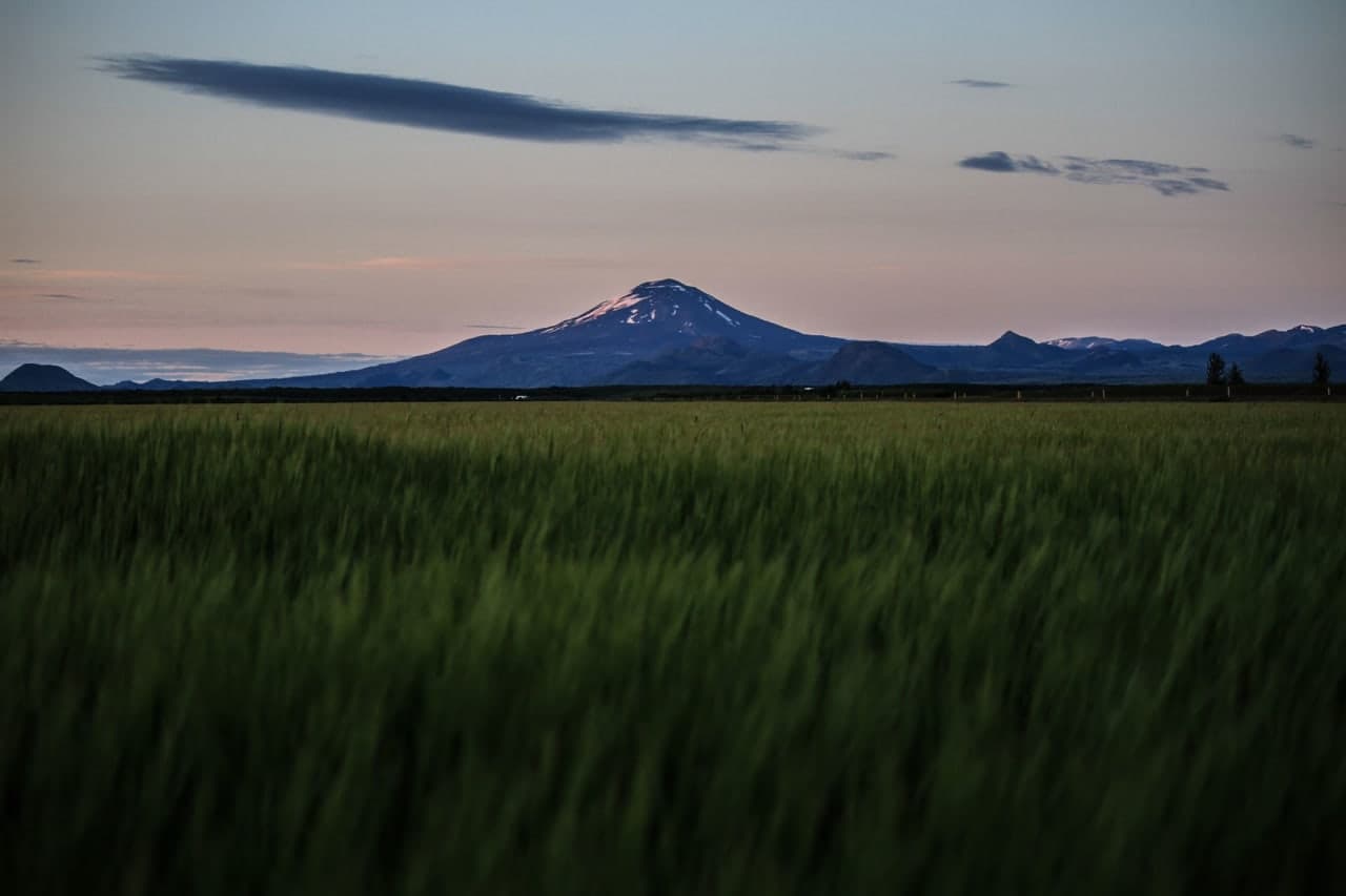
The appeal is not a single platform or waterfall-style stop. Hekla rises as a long, snowy volcanic ridge above farms, lava fields, and inland roads, so the visit often feels like following a powerful presence across the landscape before choosing one sensible viewpoint.
Add Hekla when the day already reaches Hella, Þjórsárdalur, or the quieter edge of the Golden Circle and the weather gives clear views. Skip it when a short first trip is already packed with Geysir, Gullfoss, Kerið, and South Coast waterfalls, or when the plan only makes sense if conditions allow a close mountain approach.
What is the safest way to experience Hekla?
For most travelers, the safest Hekla experience is a strong distant view, a lowland lava-field stop, or a guided volcano-area visit. Treat summit or close-slope plans as a separate risk decision.
Hekla is active and monitored closely. IMO notes that the volcano has sometimes shown pre-eruptive signals only shortly before an eruption, which is why a close-range plan should never be handled like a normal scenic walk.
If your goal is to understand the volcano rather than stand on it, the better travel experience is usually to view the ridge from safe roads and valleys, add nearby lava-field scenery, and let official updates decide how close the day should go.
Hekla’s ridge is impressive from below; getting closer should depend on current conditions, not only ambition.
What does Hekla feel like from the road and lowlands?
The most memorable part of Hekla is often its scale from a distance: a long ridge sitting above farms, black lava, rivers, and open South Iceland weather.
On a clear day, Hekla can dominate the inland horizon. The mountain looks calmer than its reputation suggests, which is part of what makes the place powerful: ordinary farms and green fields sit below one of Iceland’s most closely watched volcanic systems.
The lowland view is part of the experience: Hekla is visible above farms and lava rather than isolated in wilderness.
Cloud can hide the top, wind can make exposed stops unpleasant, and winter or shoulder-season snow can change the whole tone. If Hekla is covered, the day needs nearby alternatives instead of a stubborn push toward the mountain.
How do roads, weather, and volcano updates change the plan?
Roads, weather, and volcanic information should decide the final version of a Hekla day. A map can make the area look simple; the actual decision depends on visibility, surface conditions, vehicle fit, and official updates.
Views from normal South Iceland roads are low-friction, but closer approaches can involve rougher roads and seasonal limits. Road 225 and routes toward the highlands should be checked before you assume they suit your vehicle, rental terms, or the day’s weather.
Snow, cloud, and road conditions can turn a simple-looking Hekla plan into a different day.
Hekla planning choices
Plan
Best when
Main check
Distant viewpoint
You want a low-friction volcanic landmark in a South Iceland day
Visibility and safe stopping places
Closer lava-field area
You have time, a suitable vehicle, and conditions look stable
Road status, weather, and local advice
Guided volcano-area visit
You want context and safer terrain decisions
Operator status plus official conditions
Summit-style ambition
Only with serious preparation and current local guidance
IMO, SafeTravel, weather, road status, and a conservative turnaround point
How much time should you give the Hekla area?
Give Hekla anywhere from a few minutes to most of a day, depending on whether you are only viewing the mountain, adding nearby valleys, or trying to reach rougher volcanic terrain.
Quick view: build in a short stop only if the mountain is visible and the stopping place is safe.
Half-day area visit: pair Hekla with Þjórsárdalur, Gjáin, Hjálparfoss-style scenery, or a slower inland loop.
Longer guided or high-clearance plan: leave space for road checks, weather changes, lava-field stops, and a no-go decision.
A clear view can be the whole reward; if the ridge is hidden, keep the day flexible.
The mistake is giving Hekla a fixed slot without a fallback. It is much easier to enjoy when the day can flex toward Geysir, Gullfoss, Kerið, Brúarfoss, or South Iceland waterfalls if cloud or conditions make the volcano less useful.
What nearby stops make Hekla easier to justify?
Hekla is strongest when it belongs to a cluster. Use nearby places to decide whether the volcano adds meaning to the day or creates too much extra driving.
From the Golden Circle side, Geysir and Gullfoss give you high-reward classic stops before deciding whether to continue toward quieter inland scenery. Kerið and Brúarfoss are easier add-ons when you want a more controlled day.
From the South Iceland side, Hekla works better with Hella, Þjórsárdalur, Gjáin, Hjálparfoss, and lava-field viewpoints than with a rushed attempt to combine everything from Reykjavík to Vík in one day.
Use this guide to shape the plan, then let official sources decide whether the day is sensible. Hekla is not a place where old access notes should override current information.
Regional visitor context and local route information.
Hekla FAQ
These questions matter because Hekla is famous, active, and easy to underestimate from a map.
Can you hike to the top of Hekla?
You should not treat Hekla as a casual summit hike. Close-range plans need current official checks, suitable weather, local advice, and a conservative turnaround plan because the volcano can give very short warning before eruption.
Is Hekla safe to visit?
Hekla can be safe to view from appropriate roads and lowland areas when conditions are normal. Getting close to the mountain is a different decision and should depend on IMO, SafeTravel, weather, and road information.
When did Hekla last erupt?
Hekla last erupted in 2000 according to the Icelandic Meteorological Office. That fact should not be used as a safety forecast; check current monitoring and alerts before any close approach.
Is Hekla worth it on a first Iceland trip?
Hekla is worth it if your first trip already has time for inland South Iceland. If your route is short and already includes Geysir, Gullfoss, Kerið, and South Coast waterfalls, Hekla may be better as a distant view.
Map
See where this stop sits
Use nearby places and useful bases before opening directions.
Region
South Iceland
Works well with
Golden Circle / South Coast
Useful base
Selfoss
Interactive planning map for Hekla
Interactive map
Load the map when you need it
Place context and external map links remain available without loading it.
Planning context
Use the wider destination guides
Open the region or practical guide that resolves the next planning decision.