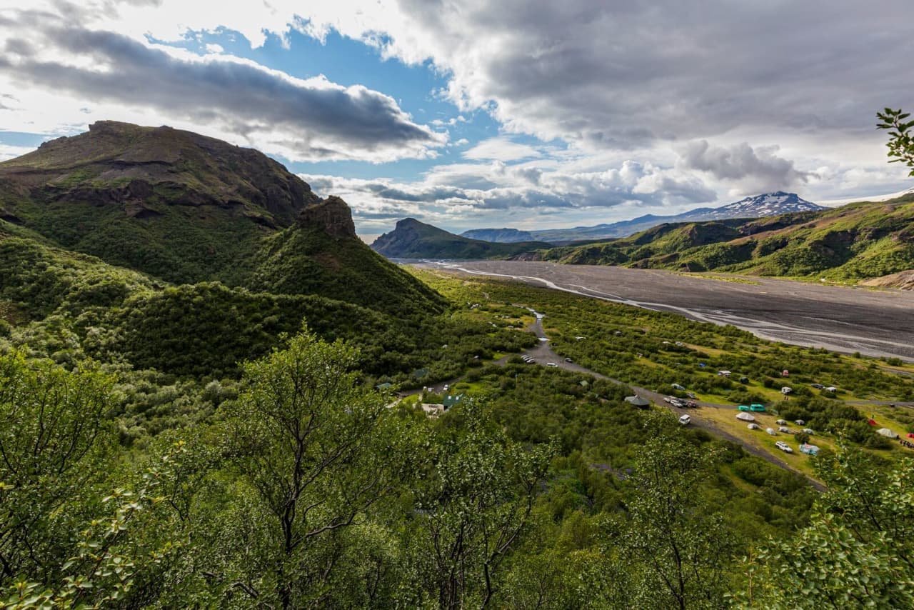
Þórsmörk is a green Highland valley cut by glacial rivers and enclosed by steep ridges and ice-covered mountains. Short walks and long trails begin inside the valley, but most visitors should leave its difficult river crossings to a Highland bus or experienced local operator.
Valley and access
What it is
Sheltered Highland valley and hiking area
Landscape
Birch scrub, ravines, braided rivers, ridges and glaciers
Main season
Summer, subject to road, river and operator conditions
Visit length
A full day for most visitors; longer for major trails
Simplest access
Seasonal Highland bus or experienced local operator
In this guide
A green valley between rivers and glaciers
Þórsmörk lies behind the South Coast between glacial rivers and the ice-covered mountains of Eyjafjallajökull and Mýrdalsjökull.
The valley feels different from Iceland's barer interior. Birch and low scrub cover sheltered slopes, while ravines cut through dark rock and pale glacial water spreads across wide gravel beds below. Sharp ridges divide the views, so the landscape changes quickly as you walk rather than appearing from one fixed lookout.
Visit South Iceland describes Þórsmörk as a landscape of gorges, ravines, scrub-covered slopes and varied vegetation. The rivers help define it: Krossá runs along the southern side, while Markárfljót and Þröngá lie to the north. Their changing channels are part of the scenery and the reason access cannot be treated casually.
Regional information about the valley, vegetation, rivers, rock formations and access.
Short walks can show the scale of Þórsmörk
You do not need to complete a long-distance trail to see woodland, river flats and wide views across the valley.
Valahnúkur is a common shorter objective near Langidalur, climbing above the trees for views across Krossá and the surrounding ridges. Other marked paths pass through wooded gullies or connect visitor bases. Ask wardens about current trail conditions and choose by weather, available time and the exact place where you arrive.
Birch woodland reaches toward steep ridges, giving even lower walks a strong sense of enclosure.
Stakkholtsgjá is a separate canyon visit in the wider area, while the Laugavegur finishes in Þórsmörk and Fimmvörðuháls connects the valley with Skógar. Those longer trails require their own weather, equipment, transport and accommodation planning; their names on a local map do not turn them into day-trip extensions. 5 September 2026 safety update: SafeTravel advises against hiking Fimmvörðuháls because of dangerous trail conditions. Do not add that crossing while the advisory applies; check the dated alert in the Fimmvörðuháls guide.
Current trail, seasonal, equipment and transport guidance from the Iceland Touring Association.
River crossings make self-driving a specialist choice
Road 249 becomes the rough F249 approach, with several unbridged rivers before the main visitor areas.
The Krossá crossing near Langidalur is especially changeable and can be dangerous. Water depth, current and the location of the ford can shift after rain or melting. A large 4x4 does not make an unfamiliar crossing safe, and rental permission alone does not supply the experience needed to judge it.
The broad riverbeds are part of Þórsmörk's character and the central difficulty of reaching it by car.
For most independent travelers, a seasonal Highland bus is the straightforward option. A guided super-jeep can also combine transport with a walk. Confirm the exact stop, return time and baggage rules before booking, because Langidalur, Básar and Húsadalur are different bases rather than one compact parking area.
The visitor bases serve different walks
Langidalur, Básar and Húsadalur each provide access to part of the valley, so the arrival point affects which walks are practical.
FÍ's Skagfjörðsskáli hut is in Langidalur, near Valahnúkur and the end of Laugavegur. During its staffed season, it offers accommodation, camping, toilets, showers and simple facilities. Básar lies across the river system near routes toward Fimmvörðuháls, while Húsadalur has its own accommodation and services.
Huts provide a base for the valley, but beds, camping and transport should be checked separately.
Do not assume you can walk quickly between the three bases. Bridges, paths and river conditions determine the practical connection. A day visitor usually gets more from one well-chosen walk near the arrival point than from spending the visit trying to reach every named place.
Current hut, facilities, staffing, trail and river-access information.
A full day allows one satisfying walk
The slow approach and fixed bus times mean Þórsmörk should usually be the main destination of the day.
After arrival, allow time to speak with wardens, adjust the walk to conditions, eat and return without rushing. An overnight stay gives more flexibility for two walks or a long-distance trail connection, but it also requires accommodation or camping plans and enough food and equipment.
Þórsmörk sits behind famous South Coast stops, yet trying to combine it with a full waterfall-and-beach itinerary weakens both experiences. Seljalandsfoss may fit near the start or end of the access road if transport timing allows. Landmannalaugar is linked by Laugavegur, but it is a separate Highland destination rather than a casual same-day drive.
From higher ground, the rivers, ridges and glaciers read as one connected valley system.
Rain and meltwater can change both trail and access
Weather matters twice in Þórsmörk: it affects exposed hiking and it can raise the rivers used by vehicles.
Carry waterproof layers, insulation, food and a charged phone even on a short walk. Low cloud can obscure ridges, while wet ground makes steep sections slower. Winter travel is a serious specialist undertaking; the Langidalur hut is normally closed and ordinary visitor transport does not operate as it does in summer.
Check the road map, weather warnings, SafeTravel notices and the latest information from the transport or hut operator shortly before travel. If buses are not operating or local advice says river conditions are poor, choose another day rather than looking for a way around the warning.