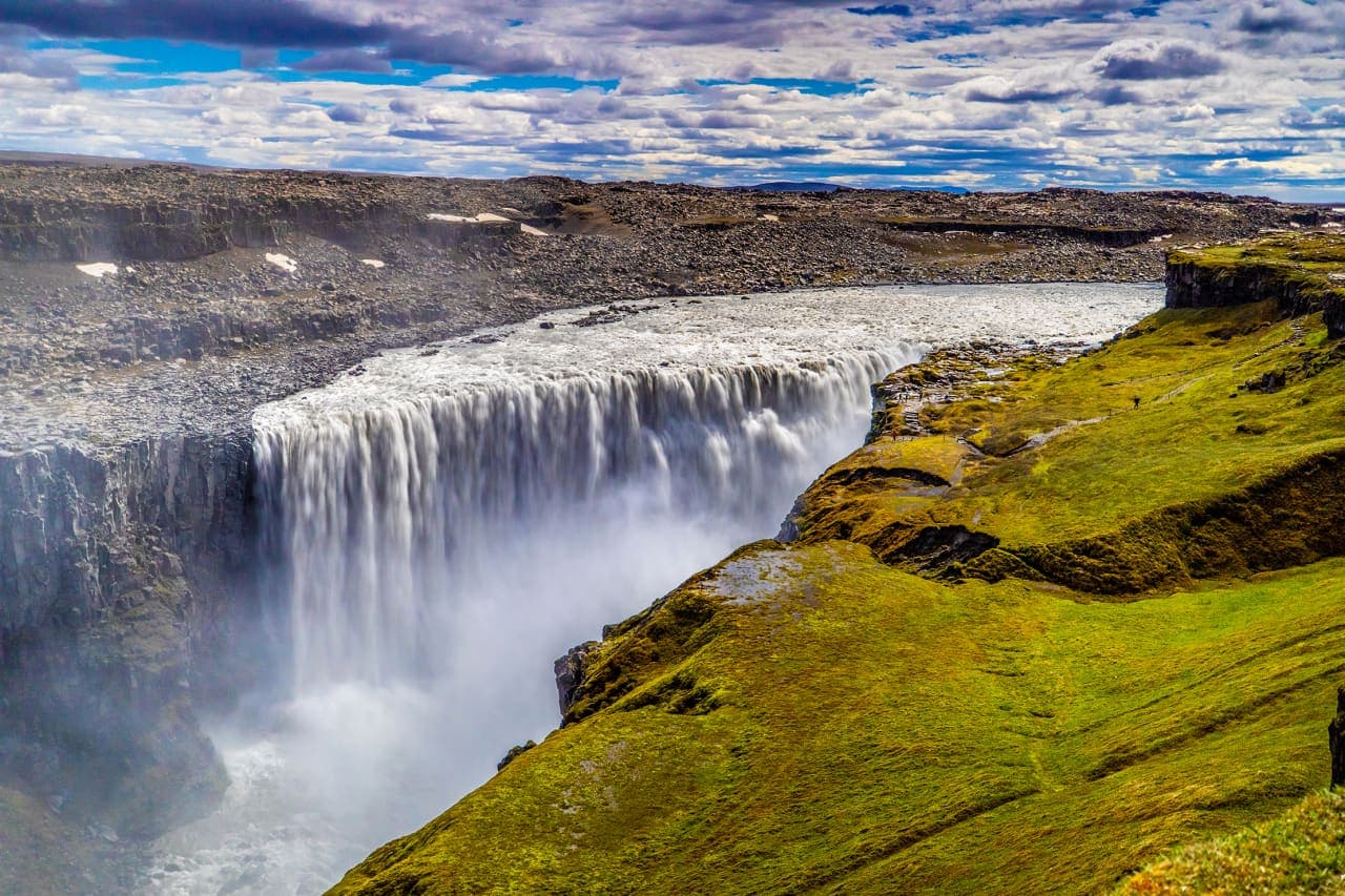
Dettifoss is a 45-meter waterfall where the sediment-heavy Jökulsá á Fjöllum drops into Jökulsárgljúfur canyon. Its scale is immediate, but the west and east approaches are different visits and neither should be chosen without current access conditions.
Waterfall facts
What it is
Glacial-river waterfall in Vatnajökull National Park
Height and width
45 meters high and about 100 meters wide
West-side walk
Park trail D1: 1.5 km return, about 30-60 minutes
Access roads
Road 862 west; gravel Road 864 east
Main conditions
Heavy spray, slippery paths, canyon edges and seasonal road access
In this guide
A glacial river drops into Jökulsárgljúfur
Dettifoss is 45 meters high and about 100 meters wide, but the physical experience is larger than those figures suggest.
The Jökulsá á Fjöllum carries gray-brown water and sediment from the Vatnajökull ice cap before reaching Jökulsárgljúfur. At Dettifoss, that broad river drops as one heavy sheet. Mist fills part of the gorge, the ground can vibrate near the falls, and the opposite canyon wall gives the water a scale that a close photograph often loses.
Vatnajökull National Park describes Dettifoss as Europe's most powerful waterfall. The label is useful shorthand for the impression, but visitors do not need a superlative to understand the place: the combination of water volume, sediment, sound and enclosed canyon makes it unlike the cleaner, curved form of Goðafoss.
The force is also changing the canyon. The park says erosion moves the waterfall gradually upstream, at roughly half a meter each year. Softer material is removed from beneath harder rock until sections of the lip collapse. Dettifoss is therefore an active edge in the canyon, not a permanent stone step with water passing over it.
Flow is never visually identical. Meltwater and recent weather alter the amount of water, while the suspended sediment keeps the river opaque. More water can make the falling sheet look continuous; lower flow exposes breaks and dark ledges across the lip. The canyon walls remain the clearest reference for judging the change.
Official trail distance, walking time and west-bank safety guidance.
Photo guide
Dettifoss in photos
Snow and frost can cover the approach and hide the canyon edge.
The west and east banks are separate visits
Road 862 reaches the west side and Road 864 reaches the east. There is no bridge at Dettifoss, so changing sides means a substantial drive around rather than a short walk.
The west side is the more developed approach. Road 862 is paved, and the national park's D1 route starts at the west parking area. The published trail is 1.5 kilometers return and usually takes about 30-60 minutes, although spray, crowds, snow or slow footing can lengthen the visit.
Road 864 on the east side is gravel and has a shorter practical season. It gives a different angle across the falls, but its surface and opening cannot be assumed from conditions on Road 862. Clear weather on the main highway does not prove that the east approach is open or comfortable.
The west-bank route is a defined walk from the parking area, not a roadside viewpoint.
For most first visits, the west side is the simpler choice because the road and park trail are more developed. The east side can still suit travelers already using Road 864 when it is officially open and its gravel condition fits the vehicle and driver. Choose one side deliberately; collecting both usually adds substantial travel without doubling the value.
Allow roughly 60-90 minutes for the west side when you want an unhurried walk, time at more than one position and a careful return. The park's 30-60 minute estimate covers the D1 walk itself. Waiting for visibility through the spray, changing a wet layer or moving slowly over uneven ground can reasonably extend the stop.
Spray is strongest on the west-bank path
The waterfall's spray commonly blows over the west viewpoint and footpaths, making wet rock and loose surfaces part of the normal visit.
The opposing canyon wall and rising spray reveal the waterfall's scale.
Use a waterproof outer layer even when the parking area is dry. Shoes need grip, and cameras or phones need protection. The closer path can become slick enough that a slow return takes more time than the approach. Stay inside ropes and marked areas; a wet canyon edge gives little margin for a mistake.
In severe frost, the park warns that large snow deposits can form near the waterfall and advises against going all the way to the canyon edge. That warning matters even when a path remains visible. Snow can hide uneven rock, and ice created by spray may not match conditions elsewhere.
Selfoss adds a quieter shape to the same river
The park's D2 route combines Dettifoss with Selfoss, a lower and wider waterfall upstream on the same river.
The official combined route is 2.5 kilometers and takes about one hour in ordinary conditions. Selfoss does not repeat Dettifoss: water spreads across a long broken ledge, creating a calmer, more open shape. The contrast helps explain the river rather than simply adding another name to the day.
Add Selfoss when visibility and footing are good and you have enough time to walk without rushing. Skip it when spray, ice, fatigue or a closing weather window already makes Dettifoss the sensible limit. Longer canyon hikes require a separate decision and should not be inferred from the easy rating of D1 or D2.
Road status decides whether the visit is practical
Published seasonal patterns are background only. Current road status is the decision source for both approaches.
Visit North Iceland notes that gravel Road 864 closes in winter and often does not open until early summer. It also states that paved Road 862 has a period without winter service. These details explain why access differs, but dates can shift with snow, thaw, mud and maintenance.
Check the exact road number on Umferðin before leaving the main route, then check wind, precipitation and visibility. If conditions are deteriorating, Dettifoss should be removed from the day rather than used as a reason to continue onto an uncertain side road.
Dettifoss is one point within Jökulsárgljúfur, a long canyon landscape that continues toward Hljóðaklettar and Ásbyrgi.
Dettifoss belongs to a continuing river canyon, not an isolated viewing bowl.
Hljóðaklettar focuses on basalt formations and walking, while Ásbyrgi opens into a broad horseshoe-shaped canyon with woodland. Lake Mývatn offers a different volcanic and wetland landscape. Each deserves its own time; their proximity on a map does not make every combination sensible in poor weather or short daylight.