Austari-Jökulsá is a powerful glacial river and canyon in Skagafjörður, best considered when guided rafting, summer conditions, and a slower North Iceland route fit your plan, with enough flexibility for conditions and nearby route choices.
Quick guide
Type
Glacial river, canyon scenery, and guided whitewater rafting area
Region
Skagafjörður in North Iceland, near Varmahlíð and Austurdalur
Route context
Best as a Skagafjörður detour on a slower north-coast or Ring Road segment
Time to allow
Several hours if rafting; much less only for route context or nearby viewpoints
Best experience
A guided river trip through narrow canyon scenery when conditions and operator schedules align
Access note
Do not treat the canyon as an informal self-guided water stop; check operators, roads, weather, and safety conditions
Season note
Primarily a summer adventure context; operator, river, and weather conditions should decide the plan
Nearby pairings
Austurdalur, Varmahlíð, Glaumbær, Sauðárkrókur, Goðafoss, and wider North Iceland routes
Is Austari-Jökulsá worth adding to a North Iceland trip?
Yes, Austari-Jökulsá is worth adding when your route already gives Skagafjörður enough time and you want a wild river-canyon experience. It is a weaker choice if you only need a quick scenic pullout between long driving days.
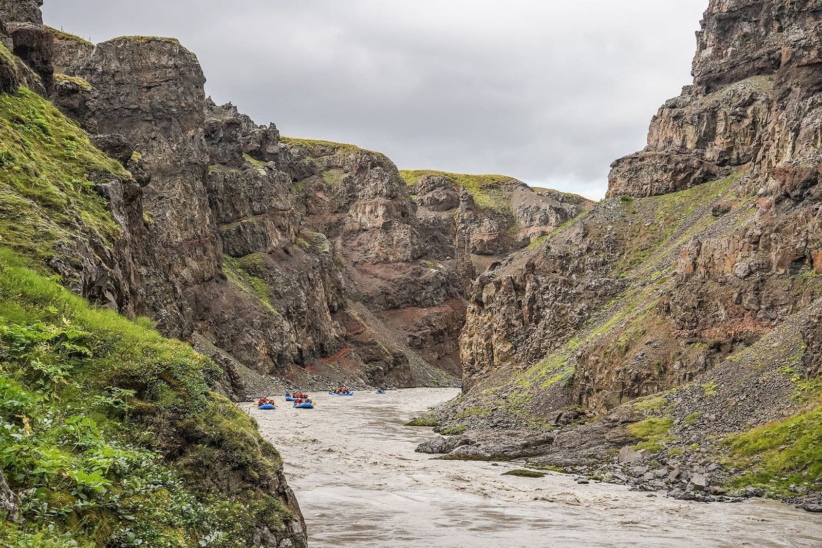
The useful way to think about the river is not as another easy stop on a list. Austari-Jökulsá is a glacial river with steep canyon walls, fast water, and a reputation built around guided East Glacial River rafting. The place has real visual drama, but most travelers will not experience the best parts by simply driving past.
That makes it different from Goðafoss or Glaumbær. Goðafoss gives you a straightforward Route 1 waterfall stop, and Glaumbær gives you a compact cultural visit in Skagafjörður. Austari-Jökulsá asks for more commitment: time, season, weather checks, and usually an operator-led plan.
Photo guide
Austari-Jökulsá in photos
1 / 2
The GTI manifest image supports the exact-place identity but is less useful than the wider canyon views.
Worth the stop?
When this stop makes sense
Good match for
travelers spending real time in Skagafjörður
guided whitewater rafting plans
North Iceland routes that need a high-energy canyon stop
visitors comparing Skagafjörður with the Diamond Circle
Think twice if
casual roadside sightseeing without a booked activity
families or travelers avoiding high-intensity river conditions
What does the East Glacial River canyon feel like?
The canyon feels narrow, loud, and physical: grey glacial water pushing between dark rock walls, green slopes above the gorge, and a river that looks more serious than calm from close range.
In good summer conditions the scene is dramatic rather than tidy. The water is opaque and fast, the canyon walls close in around bends, and the best views often include rafts because guided trips are how most visitors enter the river corridor safely.
If you are not rafting, the value is mostly route awareness: understanding why Skagafjörður has a stronger adventure edge than it first appears from the main road. If you are rafting, the canyon becomes the point of the day rather than an add-on.
How should non-rafters think about this river?
Non-rafters should treat Austari-Jökulsá as a landscape and planning reference, not as an informal self-guided river attraction. The strongest public access experience is operator-led rafting, while casual visitors are usually better served by nearby towns, farms, and cultural stops.
This is where the page has to be honest. A named river can be a valid attraction, but Austari-Jökulsá is not the same kind of stop as a signed waterfall viewpoint. Local and operator sources place it near Varmahlíð and show why the river is primarily known for whitewater, canyon scenery, and guided access rather than casual roadside viewing.
If that sounds like too much friction, choose Glaumbær for a lower-pressure Skagafjörður stop, or use Goðafoss when the day needs an easy scenic break on Route 1.
How much time and planning does it need?
Allow several hours if rafting is part of the plan. If you only want to understand the river’s place in Skagafjörður, keep it as background context and give your actual stop time to nearby places with clearer visitor access.
Simple planning choices for Austari-Jökulsá
Plan
Time to allow
Best when
Guided rafting focus
Several hours
The operator schedule, river conditions, and your group’s ability all line up.
Skagafjörður route context
Flexible
You are using the page to understand why this valley area matters before choosing nearby stops.
Quick scenic substitute
Not ideal
Choose Glaumbær, Goðafoss, or another signed stop instead of forcing the river into a rushed day.
The river is best planned as an activity-led canyon experience, not a quick roadside photo stop.
Current details matter because river activities depend on more than map distance. Confirm season, meeting point, required equipment, age and ability rules, cancellation terms, weather, roads, and travel-condition alerts before treating the stop as fixed.
Where does Austari-Jökulsá fit with Skagafjörður and North Iceland?
Austari-Jökulsá belongs first to Skagafjörður, then to a broader North Iceland route. It pairs more naturally with Varmahlíð, Austurdalur, Sauðárkrókur, and Glaumbær than with a rushed same-day checklist of every northern landmark.
The most natural planning context is Skagafjörður, with nearby names such as Austurdalur, Reykjafoss, Fosslaug, 1238 The Battle of Iceland, and Akureyri. That points to a real regional day rather than a loose adventure keyword.
The canyon scale makes Austari-Jökulsá a Skagafjörður anchor when the day has enough room.
If you are crossing North Iceland quickly, make a cleaner choice. Glaumbær gives Skagafjörður cultural value with easier timing; Goðafoss gives a highly efficient scenic stop; Ásbyrgi and Dettifoss belong to a different canyon-and-waterfall cluster farther east.
What should you check before committing?
Check current operator information first if rafting is the reason to go, then verify roads, weather, and travel alerts before shaping the surrounding day. The page should help you ask the right questions, not replace live conditions.
For this river, the most fragile facts are practical ones: season, water level, departures, meeting place, age limits, physical requirements, and cancellation rules. Those can change, so use operator pages for the trip details and official Iceland sources for travel conditions.
Rafting images are useful here because they show the river’s real visitor rhythm and safety context.
Travel alerts and safety context for outdoor plans.
Common Austari-Jökulsá planning questions
These questions matter because this is a higher-friction river stop rather than a simple viewpoint.
Can you visit Austari-Jökulsá without rafting?
Yes, you can use the area as Skagafjörður landscape context, but the most distinctive visitor experience is guided rafting rather than informal self-guided river access.
Is Austari-Jökulsá a good family stop?
Not for every family. Check operator age, swimming, fitness, and safety requirements before assuming the East Glacial River suits your group.
Is Austari-Jökulsá close to the Ring Road?
It is in the Varmahlíð and Skagafjörður area, so it can work from a North Iceland route, but the practical plan depends on the exact meeting point and road conditions.
What should I pair with Austari-Jökulsá?
Pair it with Skagafjörður stops such as Glaumbær, Varmahlíð, Austurdalur, Sauðárkrókur, or nearby places such as Reykjafoss and Fosslaug when those are available.
Map
See where this stop sits
Use nearby places and useful bases before opening directions.
Region
North Iceland
Works well with
Ring Road / Arctic Coast Way
Useful base
Sauðárkrókur
Interactive planning map for Austari-Jökulsá
Austari-Jökulsá
Keep exploring
Put this place in route context
Use nearby places and planning pages to decide whether this stop strengthens the route or stays optional.