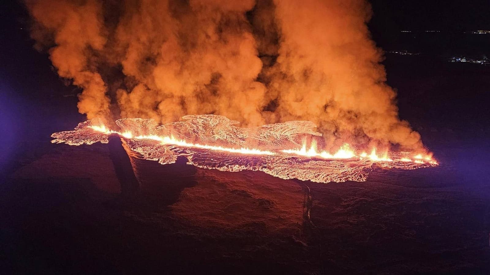
Hagafell Volcano is a recent Grindavik-area Reykjanes lava landscape for travelers who want volcanic context, can respect closures, and are willing to let official safety, gas, road, and weather checks decide the visit.
Geology snapshot
Type
Volcano area, recent lava landscape, and Reykjanes safety-sensitive stop
Region
Reykjanes Peninsula, by Grindavik
Route context
Best as conditional context in a Reykjanes day, not a fixed sightseeing promise
Time to allow
A short context stop if official guidance supports it; longer only with a safe, specific plan
Best experience
Clear visibility, a flexible Reykjanes route, and respect for official boundaries
In this guide
Hagafell Volcano: but only when you want recent Grindavik-area lava context and can keep the plan flexible
Yes, but only when you want recent Grindavik-area lava context and can keep the plan flexible. Hagafell is not a normal pull-in viewpoint or an active-lava promise.
The value is understanding how the recent Sundhnukagigar and Hagafell eruptions changed the edge of Grindavik. You are looking for place context: dark new lava, protective barriers, road-sensitive geography, and a volcanic landscape that still demands restraint.
Add Hagafell for a repeat visitor or serious Reykjanes self-driver who can adapt around official guidance. Skip it for a tired arrival day, a fixed Blue Lagoon schedule, or anyone who mainly wants a simple scenic stop.
Photo guide
Hagafell Volcano in photos
1 / 2
The broader Sundhnukagigar system gives Hagafell its Reykjanes route context.
What can you actually see around Hagafell?
Expect a raw Reykjanes lava landscape rather than a polished attraction. Depending on safe access and visibility, the important sights are the mountain, fresh lava fields, barriers, and the closeness of the volcanic area to Grindavik.
Hagafell sits in the same broad volcanic story as Sundhnukagigar, Fagradalsfjall, and Litli-Hrutur. That makes it useful for travelers trying to understand why Reykjanes feels different from older, settled sightseeing routes.
Infrastructure proximity is the reason Hagafell needs sober route and safety planning.
The visit should feel more like reading a changed landscape than checking off a viewpoint. Look for scale, distance, barriers, lava edges, road context, and signs of how close the eruption area came to everyday infrastructure.
How close is Hagafell to Grindavik and Blue Lagoon?
Hagafell is part of the Grindavik-side Reykjanes cluster, close enough to Blue Lagoon, Hopsnes, and several peninsula sights that it can affect a real route day. That closeness is also why caution matters.
Do not plan Hagafell as if it were an ordinary stop between spa time and the airport. The nearby choices are stronger when you treat them as alternatives: Blue Lagoon for a booked bathing experience, Hopsnes for coastal Grindavik context, and Brimketill Lava Rock Pool for a short sea-and-lava viewpoint.
Aerial eruption views help explain the scale, but they should not be read as access advice.
Hagafell Volcano: allow flexible time rather than a fixed sightseeing slot
Allow flexible time rather than a fixed sightseeing slot. Hagafell may be a short context stop from a safe legal viewing area, or it may be the wrong choice for the day.
The effort is not only walking distance. It is the judgement required before you go: checking roads, wind, visibility, gas, air quality, access guidance, and whether your group is prepared to turn the stop into a no-go decision.
Older crater-row context shows that Hagafell belongs to a larger volcanic system, not one isolated viewpoint.
How to size a Hagafell plan
Situation
Better planning choice
Flexible Reykjanes self-drive day
Keep Hagafell conditional and pair it with one or two easier peninsula stops
Main goal is a volcano hike
Compare Fagradalsfjall and Litli-Hrutur before choosing Hagafell
Fixed airport or spa timing
Use Blue Lagoon, Hopsnes, Brimketill, or another low-friction stop instead
Poor visibility, wind, gas, or road uncertainty
Skip the volcano area and keep the day on safer, clearer route anchors
Check official visitor guidance, SafeTravel, road notifications, weather, gas, and air-quality information before you make Hagafell part of the day
Check official visitor guidance, SafeTravel, road notifications, weather, gas, and air-quality information before you make Hagafell part of the day. The landscape is recent, fragile, and condition-sensitive.
Never walk on fresh or cooling lava. A dark crust can hide heat, unstable cavities, sharp edges, and gas hazards. Stay on marked legal routes, respect closures, and treat dramatic older eruption photos as history rather than access guidance.
Road and utility impacts are part of the practical safety context around Hagafell.
This is especially important if you are linking Hagafell with winter or shoulder-season driving. Use winter driving in Iceland before making exposed Reykjanes volcano stops part of a cold-season plan.
When should you choose an easier Reykjanes stop?
Choose an easier stop when the Hagafell plan feels brittle. Reykjanes has plenty of strong places that do not require the same level of volcano-area judgement.
For short, legible stops, use Bridge Between Continents, Gunnuhver, Reykjanesviti, Brimketill, or Hopsnes. For a bigger volcano comparison, use Fagradalsfjall or Litli-Hrutur and decide whether a hike-first day is realistic.
Wide eruption-area imagery gives useful context, but Hagafell planning still depends on official checks.
The Reykjanes Peninsula road trip is the better next page if you are trying to place Hagafell inside a full day. Let the route shape decide whether the volcano context adds meaning or just pressure.
Go if you want recent lava context and can change plans.
Skip if you need a guaranteed easy stop with low decision load.
Switch to Keilir, Kleifarvatn, Gunnuhver, or Reykjanesviti if the group wants a clearer payoff.
Hagafell Volcano: use official and regional sources for the details that can change
Use official and regional sources for the details that can change: access, roads, gas, weather, warnings, and local visitor guidance around Grindavik and the eruption area.
Stable planning advice can explain why Hagafell matters. It cannot replace official day-of judgement for a volcanic area near a town, roads, infrastructure, fresh lava, and gas-sensitive terrain.
Road notifications and driving condition checks before heading onto Reykjanes roads.
Hagafell Volcano FAQ
The practical questions are less about whether Hagafell is dramatic and more about what kind of visit is responsible.
Can you see active lava at Hagafell Volcano?
Do not plan on active lava. Treat Hagafell as recent volcanic landscape context and use official sources for any eruption-area guidance before you travel.
Is Hagafell a normal sightseeing stop?
No. Hagafell is more conditional than a typical viewpoint because volcanic activity, fresh lava, gas, roads, and local boundaries can shape the visit.
What should I pair with Hagafell?
Pair it only inside a flexible Reykjanes day. Fagradalsfjall, Litli-Hrutur, Blue Lagoon, Hopsnes, Brimketill, Gunnuhver, Reykjanesviti, and Kleifarvatn are the main comparisons.
Should I visit Hagafell on an airport day?
Usually no, unless the plan has generous buffer and official checks support the route. Airport and spa days are often better with simpler Reykjanes stops.