Bridge Between Continents is a symbolic 2002 footbridge over a real Reykjanes fissure, useful as a short geology stop only when current crack warnings, weather, and a wider western-peninsula route support it.
Geology snapshot
Type
Symbolic footbridge over a Reykjanes rift
Region
Reykjanes Peninsula, near Sandvik and Hafnir
Route fit
Best as a quick stop on a western Reykjanes self-drive loop
Time to allow
Plan a short stop, with extra buffer for wind, photos, and road conditions
Best experience
Walk the bridge, read the site signs, and view the dark fissure below
In this guide
Bridge Between Continents is worth a short stop when you are already driving the western Reykjanes Peninsula
Yes, Bridge Between Continents is worth a short stop when you are already driving the western Reykjanes Peninsula. It is not worth reshaping a day around by itself.
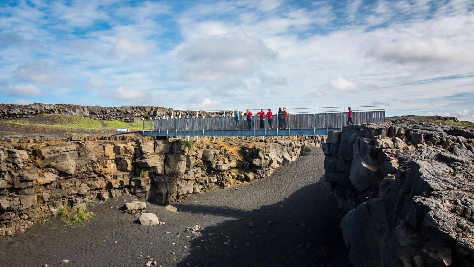
The attraction is small but clear: a pedestrian bridge spans a dark fissure in a stark lava landscape, with signs explaining the symbolic crossing between the North American and Eurasian plates. It gives Reykjanes geology a simple, physical shape.
Go for the bridge, the rift view, the photo, and the quick leg stretch between stronger nearby stops. Do not go expecting a major canyon, a long walk, or the kind of natural drama you get at Gunnuhver or Reykjanesviti.
Photo guide
Bridge Between Continents in photos
The stop is short, but the landscape makes the plate-boundary idea visible enough for most travelers.
You see a compact footbridge, a rocky fissure, black sand and lava, and open Reykjanes sky
You see a compact footbridge, a rocky fissure, black sand and lava, and open Reykjanes sky. The value is how quickly the site turns plate-boundary language into something visible.
The bridge itself is straightforward, which is part of the appeal. Built in 2002 and known as Leif the Lucky's Bridge, it is an interpretive marker rather than a survey line pinpointing a neat continental border. You cross a real tension fissure in the wider plate-boundary zone, then use the signs and landscape to understand the rifting that shapes Reykjanes.
The fissure view is more useful than the bridge alone when you want to understand why the stop exists.The straight-on fissure-floor view makes the bridge's symbolic scale and the real volcanic crack easier to separate.
The surrounding landscape is exposed and spare: low rock, open wind, black ground, and a sense of volcanic terrain stretching in several directions. That makes the stop feel different from polished first-trip landmarks, even though the visit is short.
How long should you allow here?
Most travelers should treat Bridge Between Continents as a brief stop. The experience is quick unless photos, wind, children, or road timing slow the visit.
The best plan is to keep the bridge lightweight. Stop, walk the bridge, read the signs, take the rift photo if conditions cooperate, and continue the Reykjanes loop. If the day starts to feel rushed, this is one of the easier stops to drop.
Bridge Between Continents planning fit
Situation
How to treat the stop
Western Reykjanes loop
Add it as a quick geology stop between stronger anchors.
Airport day with enough buffer
Use it only if the stop does not create timing pressure.
Strong wind or poor visibility
Keep expectations low and check official conditions first.
Limited first-trip route
Prioritize larger anchors before adding this compact landmark.
The interpretive signs make the stop easy to understand quickly.
Where does it fit on a Reykjanes route?
Bridge Between Continents fits best in the western Reykjanes cluster, especially when paired with geothermal, coastal, and lava-landscape stops instead of visited alone.
A practical loop might compare the bridge with Gunnuhver for geothermal force, Reykjanesviti for lighthouse and coast context, Sandvik for black-sand landscape, and Brimketill Lava Rock Pool for wave-carved lava. That mix gives the short bridge stop a stronger purpose.
Blue Lagoon can also fit nearby, but it changes the rhythm of the day. If spa timing is fixed, keep the bridge optional rather than squeezing every Reykjanes stop into the same window.
For route planning, use the Reykjanes Peninsula Road Trip when you need a full sequence rather than a loose list of sights. The bridge works best when it supports the drive, not when the drive exists only for the bridge.
Check official visitor, road, weather, and safety sources before relying on the bridge in a tight plan
Check official visitor, road, weather, and safety sources before relying on the bridge in a tight plan. Reykjanes is compact, but conditions can still change the value of exposed stops.
The site is simple, but the wider peninsula can be affected by wind, winter driving, volcanic updates, local access changes, and low visibility. On 2026-07-22, both Visit Reykjanes and Reykjanes Geopark carried warnings about new or reopened cracks near the attraction. Treat that as a reason to check the live official page, stay on marked paths, and keep away from cracks and edges—not as an evergreen promise that every part of the site is open.
Go if you want a quick, easy-to-understand geology stop inside a western Reykjanes day.
Skip if the weather is poor, your airport timing is tight, or you need a larger attraction payoff.
Check official visitor information, SafeTravel, Umferdin, and Vedur before making it fixed on a road-sensitive day.
Use for wind, weather warnings, and volcanic-hazard context.
Bridge Between Continents FAQ
These are the questions that decide whether the bridge belongs in a real Reykjanes plan.
Is Bridge Between Continents a major attraction?
No, it is a compact symbolic stop. It works best as one part of a Reykjanes loop, not as the main destination for a long day.
Can you walk across the bridge?
Yes, the normal visitor experience is walking onto the footbridge and viewing the fissure. Check official visitor information before relying on access in a tight plan.
What should I pair with Bridge Between Continents?