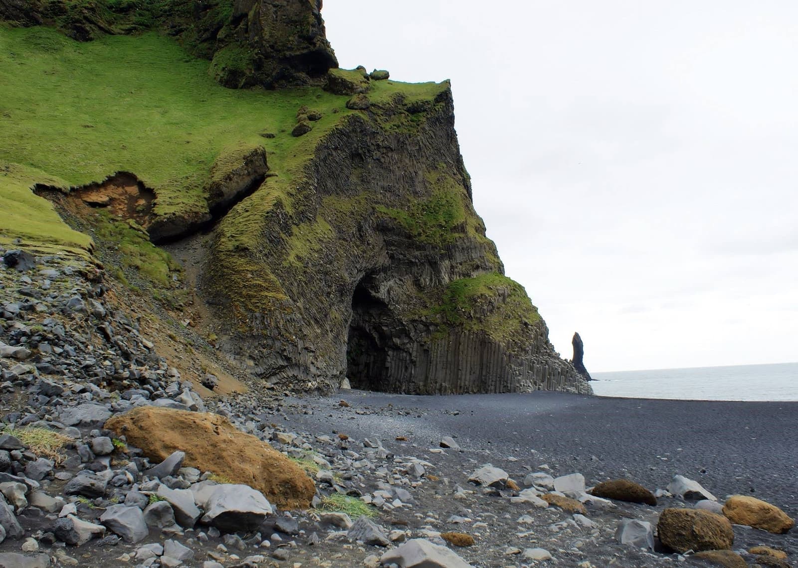
Halsanefshellir Cave is the basalt sea cave at Reynisfjara, worth seeing as part of the black-sand beach stop when surf, erosion, warning signs, and local guidance allow a safe viewpoint visit.
Coast snapshot
Type
Basalt sea cave and Reynisfjara viewpoint
Region
South Iceland, at Reynisfjara near Vik
Route role
Short South Coast and Ring Road add-on inside a Reynisfjara stop
Time to allow
About 20 to 45 minutes as part of Reynisfjara, plus safety and weather buffer
Best experience
View the cave, basalt columns, surf, and Reynisdrangar from a safe area
In this guide
Is Halsanefshellir Cave worth visiting?
Yes, if you are already visiting Reynisfjara and understand that the cave is a safety-sensitive viewpoint, not a cave you should expect to enter.
Halsanefshellir is the dramatic basalt sea cave at the edge of Reynisfjara black sand beach. Its value is visual: dark volcanic sand, hexagonal columns, cliff shadow, Atlantic surf, and the nearby Reynisdrangar sea stacks all compress into one compact view.
Add the cave to a South Coast day when Reynisfjara is already planned and your group can accept a conservative visit. Leave it off the plan when the visit depends on pushing past signs, chasing an old cave-entry photo, or turning a short beach stop into the risk point of the day.
Inside the cave and Reynisfjara cliffs
The cave is a short, highly visual feature: basalt columns at the cliff edge, black sand or rock below, and the Atlantic close enough to control the mood of the stop.
The most recognizable detail is the columnar basalt around the cave mouth. These geometric rock faces make the stop feel different from a normal beach viewpoint and explain why so many Reynisfjara photos focus on this end of the beach.
Halsanefshellir makes most sense as part of the broader Reynisfjara stop, where the cave, surf, and sea stacks share the same safety-sensitive coastline.The cave area is defined by basalt columns and shallow sea-cave forms rather than a long underground route.
The cave also frames the wider coast. If visibility is good, the same stop connects naturally to Dyrholaey, Reynisfjall, and the sea stacks. That is why the best version of the visit is not a single close-up photo; it is understanding how the cave fits the whole Vik coastline.
Use the cave view to decide how long the stop deserves.
What you came for
Best use of the stop
Watch-out
Basalt cave photos
Use safe viewpoints and wider compositions that include the cave and coastline.
Do not let one photo angle pull you into unsafe surf or rockfall zones.
Reynisfjara context
Pair the cave with the black sand, sea stacks, and cliff textures.
The parent beach safety rules still control the cave visit.
South Coast route planning
Treat it as a short part of the Vik-area cluster.
A cave-only detour is rarely stronger than the full Reynisfjara decision.
Entry, surf risk, and safe viewing
Do not plan around entering the cave. Conditions at Reynisfjara can make the cave area unsafe, inaccessible, or inappropriate even when older photos show people inside.
The practical answer is to let the day decide. Reynisfjara is known for sneaker waves, strong surf, rockfall risk, and changing shoreline conditions. At a sea cave, those hazards are not separate from the attraction; they are the main access question.
The cave sits in the same surf zone that makes Reynisfjara beautiful and dangerous.
If signs, warning lights, barriers, staff, weather, or surf argue against lower-beach access, make the designated viewpoint the visit. That is not a failed stop. It is the correct way to see a place where the sea and cliff are active parts of the landscape.
Use wave behavior and official guidance to decide the visit; old cave-entry photos should not override the beach conditions in front of you.
Stay well back from the water and never turn your back on the sea.
Keep children close and away from the surf line.
Avoid cliff edges, unstable rock, and areas below loose basalt.
Treat warning lights, barriers, and local instructions as the route, not as optional advice.
Leave if the safe area feels too narrow, crowded, windy, or hard to read.
Time, footing, and tide-aware pacing
Most travelers should treat Halsanefshellir as a 20 to 45 minute part of Reynisfjara, with extra margin for weather, crowds, and safety decisions.
The effort is not a long hike. It is judgement: parking at Reynisfjara, reading the beach, staying within safe areas, taking in the cave and sea stacks, then leaving enough time for the rest of the South Coast day.
This exterior angle shows the scale of the basalt cliff and why tide and surf conditions matter before walking near the cave.
On a full South Coast Road Trip, protect the stronger anchors first. If the same day already includes Skogafoss, Seljalandsfoss, Solheimajokull Glacier, and Dyrholaey, Halsanefshellir should stay folded into the Reynisfjara stop rather than becoming another separate line item.
South Coast pairings around Reynisfjara
The strongest pairings keep Halsanefshellir inside a coherent Vik-area and South Coast plan instead of turning it into a standalone cave chase.
The cleanest pair is Reynisfjara plus Dyrholaey: one gives you beach-level cave, basalt, and surf atmosphere; the other gives you a higher view over the same coast. Reynisdrangar adds the offshore focal point, and Vik makes the area easier to pace if you are not rushing back toward Reykjavik.
Halsanefshellir works best when it supports a broader South Coast sequence rather than becoming the whole day.
Farther along the route, Skogafoss and Seljalandsfoss give the classic waterfall contrast, while Jokulsarlon and Diamond Beach belong to longer South Coast or Ring Road plans. On a five-day trip, decide whether this cave-level stop deserves time or whether the day already has enough high-impact scenery.
Waterfalls such as Seljalandsfoss are stronger route anchors; Halsanefshellir is a compact add-on inside the Reynisfjara stop.
Checks before walking onto the beach
Check the sources that can change the real visit: black-beach safety, South Iceland weather, road conditions, and any local instructions at Reynisfjara.
The safest plan is flexible. If official safety guidance or on-site instructions limit the beach, use the viewpoint and keep the rest of the South Coast day moving. If road or weather conditions make the drive uncomfortable, move the cave out of the fixed plan rather than gambling a long day on a short stop.