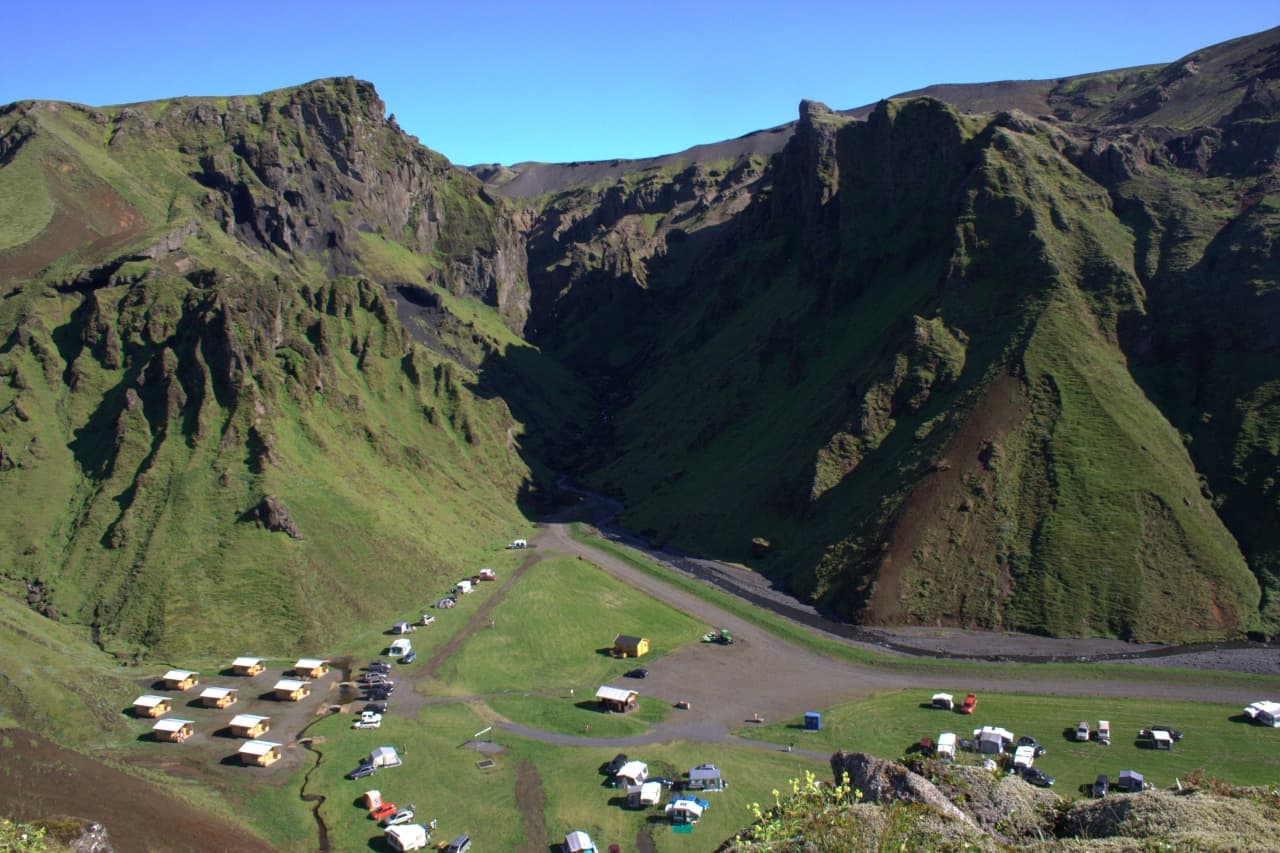
Þakgil folds a green canyon into the hills behind Vík

The place feels enclosed and sheltered after the open black-sand coast below.

Þakgil lies between Höfðabrekkuafréttur and Mýrdalssandur, in broken high ground east of Vík í Mýrdal. Steep mossy walls close around a stream and a small summer camping base. The naturally formed cave used as a communal dining shelter is part of the unusual setting, but the canyon and surrounding walking country are the main reason to come.

Its contrast with nearby Reynisfjara is immediate: green, sheltered and inland rather than exposed to the ocean. Þakgil is not one viewpoint, however. A short look at the basin gives only part of the experience; marked trails climb beyond it toward ravines, waterfalls, ridges and views toward Mýrdalsjökull.

Road 214 makes access a deliberate summer decision

The journey is about 20 km from Vík and leaves the main highway roughly 5 km east of town.

Kerlingardalsvegur, numbered 214, follows an old section of the main highway into the hills. It is a gravel approach rather than another paved South Coast pull-off. Mýrdalshreppur describes Þakgil as reachable by ordinary cars when access is open, but surface and weather still matter. Confirm the live status instead of relying on a static vehicle description.

Road 214 is a long gravel approach, so its live condition is part of the visit decision.
Gravel Road 214 crossing the open basin near Þakgil, with trail signs beside the road.

Road 214 is a long gravel approach, so its live condition is part of the visit decision.

Katla UNESCO Global Geopark states that access closes in winter. Opening dates shown by the operator and regional listing can differ, so treat Þakgil as a seasonal destination and check both before departure. If the way is closed or the journey would consume the margin needed for the return, stay near Vík.

Access and visitor information

Official trails range from half-day to full-day hikes

Official municipal figures range from a substantial half-day hike to a long mountain day.

Remundargil is the shortest of three clearly documented examples: 12.5 km, about 250 m ascent and 3-5 hours return, passing Remundargilsfoss and a viewpoint toward Kötlujökull. Mælifell is listed at 13.5 km, 400-500 m ascent and 4-5 hours. Its description warns that Afréttisá may need to be forded depending on the river channel.

Higher trails leave the sheltered basin for more exposed ridges and glacial views.
A narrow river running through steep green walls in the wider Þakgil hiking area.

Higher trails leave the sheltered basin for more exposed ridges and glacial views.

Austurafréttur is a bigger undertaking at 17 km, 500-600 m ascent and 6-8 hours. These figures describe named trails, not every possible walk from the campsite. Use the municipal descriptions and the operator's map to choose a line; do not transfer one trail's time, ascent or river conditions to another.

Official trail figures

Fragile ground and fast weather reward conservative choices

Shelter at the campsite does not describe conditions on the higher ground.

Keep to the trails: the geopark specifically identifies the vegetation as vulnerable to trampling. Higher ground can be exposed to fog, wind and rain, while a river crossing can change with runoff. Carry normal hiking layers, food and navigation backup, and turn back before markings or safe footing become uncertain.

Check Road 214 on Umferðin, then the Met Office forecast and SafeTravel alerts. A calm basin is not proof of a calm ridge. Travelers wanting a simpler alternative can stay with the established viewpoints at Dyrhólaey.

Live conditions

Seasonal facilities support longer visits

Þakgil can be visited in daytime or used as a seasonal base for the surrounding trails.

The operator lists camping, cabins, toilets and showers, with a cave serving as the common dining shelter. Availability, prices and opening dates can change, so confirm those details directly if the visit depends on them. Accommodation inventory is not a permanent place fact.

Day visitors still need enough time for the gravel journey in and out plus the chosen walk. An overnight can create more margin, but it does not make weather, access or trail checks optional. Match the visit to a named trail and the conditions at the time.