Coast snapshot
- Type
- Lighthouse on black sea cliffs
- Region
- Western Snæfellsnes inside the national park
- Best for
- Short scenic stop with coastal drama
- Time
- About 20 to 45 minutes
- Access
- Gravel spur beyond Skarðsvík and Öndverðarnes
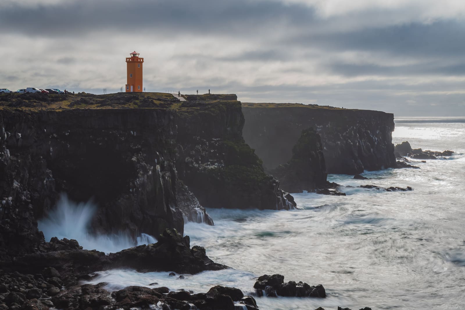
Svortuloft is a black-cliff lighthouse stop on western Snæfellsnes, useful for travelers deciding whether the rougher spur road is worth it for dramatic coast, seabird-heavy cliffs, and a short viewpoint pause beside stronger nearby stops.
Coast snapshot
Yes, when your Snæfellsnes day already reaches the western edge and one exposed lighthouse-and-cliff stop would improve the route. No, when the day is already full of stronger anchors and the gravel approach feels like unnecessary friction.
Svortuloft works because the contrast is immediate: a bright lighthouse on black cliffs with Atlantic water below. It is not a long destination and it should not be sold that way. The useful question is whether that stark west-side moment adds enough to justify leaving the easier peninsula rhythm.
If your plan already includes Skarðsvík Beach, Hellissandur, or the outer coast around Snæfellsjökull, Svortuloft can be a sharp visual finish. If the day still needs Djúpalónssandur Beach, cave time, or a long drive back, it is easier to leave this spur alone.
The stop feels harsher and more graphic than many Snæfellsnes viewpoints. The lighthouse gives the eye one fixed point, but the cliffs and open water carry the real weight.
This is not a soft beach pause or an easy village wander. The ground and coast feel darker, windier, and more exposed, which is exactly why some travelers love it. On a clear day the place reads in clean layers: lava, cliff edge, sea, and the orange tower standing against all of it.
That mood is the main payoff. Birdlife can add to the stop in the warmer season, but it should be treated as a bonus rather than the only reason to come. If visibility closes in or the wind makes the edge feel uncomfortable, the drama drops fast and the detour becomes less convincing.
The stronger version of Svortuloft is not only a lighthouse photo. Nearby Öndverðarnes adds a rougher historical and landscape layer that makes the western tip of the peninsula feel more coherent.
West Iceland describes Öndverðarnes as the westernmost point of Snæfellsnes, with remains of an older fishing settlement still visible. The official park trail from Öndverðarnes to Skálasnagi runs through black lava, passes an old fox trap, and reaches the bird-heavy cliffs that face the same coastal pocket as Svortuloft.
That does not mean everyone should turn the stop into a full walk. It means the area has more texture than a single lighthouse frame. If you want a slightly deeper reason to make the detour, this Öndverðarnes angle gives Svortuloft a stronger landscape-and-history context without pretending it is a major hiking destination.
Use the nearby stop that solves the rest of the day, not the one that simply sounds dramatic on its own.
| Nearby stop | Use it with Svortuloft when | Choose it instead when |
|---|---|---|
| Skarðsvík Beach | You want an easy color-contrast stop before or after the lighthouse. | The route needs one simpler coast stop and not another rough spur. |
| Hellissandur or Rif | You want a village pause to break up the harsher outer-coast scenery. | You need food, a calmer stop, or a more human-scale west-side moment. |
| Djúpalónssandur Beach | You have room for both a quick lighthouse detour and a heavier black-coast stop. | You only have time for one memorable shore visit and want the stronger beach experience. |
For most travelers, Skarðsvík Beach is the cleanest pairing because it sits on the same outer route and does a different job. Hellissandur and Rif are better when the day needs a village pause. Djúpalónssandur Beach wins if you want the more substantial coast stop and do not mind dropping the lighthouse spur.
If you are still shaping the whole loop, use the Snæfellsnes Peninsula Road Trip to decide whether this western edge belongs in the day at all.
The main planning question is not admission or timing. It is whether the road, wind, and your comfort near exposed coast all support the stop on that specific day.
Check official road conditions before committing to the outer west-side spur, especially after bad weather. Then check wind and visibility. Even when the map distance looks small, exposed coast can feel much bigger once the weather turns or footing starts to feel uncertain.
If the stop is only one piece of a larger peninsula day, protect the route from stubbornness. A weaker weather window is a good reason to keep Saxhóll, Hellissandur, or another easier west-side stop and let Svortuloft go.
Use for protected-area context and visitor-center information.
Use for the black-lava trail context and bird-cliff route details.
Check west-side Snæfellsnes driving conditions before relying on the spur road.
Check wind, visibility, and warnings before exposed cliff visits.
Use for broader outdoor and self-drive safety checks.
By ThorPublished Updated
Map
Use nearby places and useful bases before opening directions.
Interactive planning map for Svortuloft
Interactive map
Place context and external map links remain available without loading it.
Planning context
Open the region or practical guide that resolves the next planning decision.
Wider route
Use broader place relationships for route comparison; they are not presented as immediate nearby stops.