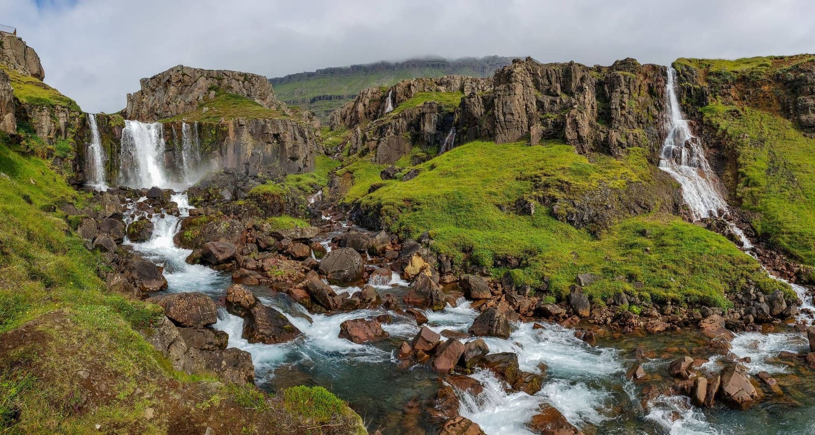
Vestdalsfossar is a series of waterfalls in Vestdalur above Seyðisfjörður. A short visit reaches the lower cascades; continuing toward Vestdalsvatn turns it into a much longer mountain walk.
Waterfall facts
Location
Vestdalur, near Seyðisfjörður in East Iceland
Approach
Road 951 on the north side of the fjord
Short visit
Allow about 30–60 minutes for the lower waterfalls
Terrain
Uneven natural paths; wet or slippery slopes
Longer hike
Vestdalsvatn requires a separate several-hour plan
In this guide
Waterfalls above Seyðisfjörður
Vestdalsfossar follows a sequence of cascades up Vestdalur, with views back over Seyðisfjörður and its fjord.
The lower waterfall walk gives you river, green slopes and open fjord views close to town. Farther inland, the valley carries an old route used for mail and trade in the late nineteenth and early twentieth centuries, with cairns and stonework still described by Visit Austurland.
Add the trail when your day already includes Seyðisfjörður and you want a short outdoor stop with real landscape payoff. Skip it when the side trip from Egilsstaðir is already tight, when low cloud makes the fjord drive uncertain, or when your group is not comfortable on uneven hillside paths.
Go if: you want a quieter waterfall walk close to town and have enough margin for wet or uneven footing.
Keep it short if: you mainly want the first cascades and fjord view before returning to town.
Skip or save it if: Road 93, rain, wind, or onward driving pressure already owns the day.
Photo guide
Vestdalsfossar Waterfall Trail in photos
1 / 2
Road and weather checks matter because the fjord approach can shape whether a hillside walk is a good idea.
The lower cascades and valley path
Start with the lower waterfalls and decide how far to continue based on the footing, visibility and time available.
The lower part gives the clearest reward for the least commitment. From the parking-side approach, the first cascades come quickly enough that the stop can work for travelers who want a scenic walk rather than a full hike.
Farther upstream are more cascades, including Arnarfossar and Selbrekkufoss in specialist trail descriptions. Expect uneven natural ground, muddy or marshy patches and steeper sections. Wet weather can make the walk slower, even when the first falls feel close.
The first waterfall area gives a strong payoff even if you do not continue the whole trail.
The best part is that the view keeps changing. The waterfalls are not one single roadside drop; they sit inside a landscape of river, green slopes, old route traces, and views back toward Seyðisfjörður fjord.
The approach still feels close to Seyðisfjörður, which is why the trail works as a flexible fjord-side stop.
Lower waterfalls or the hike toward Vestdalsvatn
The short waterfall visit and the route toward Vestdalsvatn are different commitments. Reaching the first cascades does not mean you have nearly reached the lake.
For the lower waterfalls, allow roughly 30–60 minutes for the walk, photographs and return. This is a flexible planning allowance, not an official timed circuit. Turn back earlier if rain, slippery ground or your group’s pace calls for it.
Continuing toward Vestdalsvatn takes you farther up the valley on a mountain hike. Allow several hours and obtain the detailed local hiking map before setting off. Check the precise start, destination and return route: the wider Vestdalur network includes routes beyond the lake and across the mountains.
Choose the short version when your main plan is Seyðisfjörður town plus one outdoor stop.
For Vestdalsvatn, plan the whole outing around the hike, with suitable equipment, daylight and current route advice.
Turn around early if footing, visibility, daylight, or group energy starts making the walk less enjoyable.
A longer mountain-route listing. Confirm the start and return plan locally rather than applying its distance to the short waterfall visit.
Seyðisfjörður’s slopes hold several waterfall lines, so choose Vestdalsfossar when you want a walk rather than only a roadside view.
Getting there via Roads 93 and 951
From Egilsstaðir, Road 93 crosses Fjarðarheiði to Seyðisfjörður. The lower Vestdalur approach is on Road 951, Vestdalseyrarvegur, along the north side of the fjord.
Use Seyðisfjörður as the starting point for checking local directions and the hiking map. Follow current signs for the lower trail and parking. The map pin on this guide identifies the attraction area, not a surveyed parking space.
It also pairs naturally with Gufufoss Waterfall when you want a waterfall-focused Seyðisfjörður day. Gufufoss is the easier quick stop on the mountain-road approach; Vestdalsfossar is the quieter walking choice once you are ready to spend more time outside.
For broader East Iceland planning, compare the trail against Egilsstaðir, Stórurð, and Hengifoss. Those larger route anchors can deserve more of the day, so Vestdalsfossar should support the plan rather than crowd it.
The trail makes most sense when Seyðisfjörður itself already deserves time in the day.
What nearby stops pair naturally with it?
Build the day around one clear Seyðisfjörður reason, then add Vestdalsfossar only if the pace still works.
Pair with Seyðisfjörður when you want town streets, fjord views, culture, and one nature walk in the same stop.
Pair with Seyðisfjörður Church when the group wants the classic town landmark before or after the trail.
Choose a walk beside Fjarðará when you want a riverside route from Seyðisfjörður town toward Fjarðarsel.
Pair with Gufufoss Waterfall when you want two different waterfall experiences around the same fjord approach.
Keep East Iceland in view when you are deciding whether Seyðisfjörður should be a quick detour, an overnight base, or part of a slower Eastfjords stretch.
The practical move is restraint. If the day already includes a bigger hike, a long drive, or a weather-sensitive mountain pass, Vestdalsfossar is the stop to keep optional rather than the one that breaks the schedule.
Use the wider fjord setting to decide whether Vestdalsfossar should be a quick add-on or part of a slower Seyðisfjörður stop.
Trail conditions and care for Vestdalur
Check the Eastfjords forecast, road conditions and local hiking advice before setting out.
Seyðisfjörður’s setting is part of the appeal, but it also means weather changes matter. Low cloud, wind, wet ground, and slippery slopes can change a pleasant waterfall walk into something less suitable for a mixed group.
Vestdalur and Vestdalseyri are valued for their vegetation and cultural heritage. Follow established paths, leave plants and historic remains untouched, and avoid shortcuts over fragile ground. The town’s community guidelines warn of slippery waterfall slopes and recommend getting a detailed hiking map at the tourist information centre.
The separate riverside walk from town toward Fjarðarsel.
Vestdalsfossar Waterfall Trail FAQ
Use these quick answers to decide whether the trail belongs in your Seyðisfjörður stop.
Can you visit Vestdalsfossar as a short stop?
Yes, in suitable conditions you can visit the lower waterfalls and return. Allow about 30–60 minutes as a planning estimate. A continuation toward Vestdalsvatn is a separate, several-hour hike.
Is Vestdalsfossar the same as Gufufoss?
No. Gufufoss is the better-known waterfall on the Road 93 approach to Seyðisfjörður, while Vestdalsfossar is a quieter waterfall trail closer to the fjord-side valley.
Do you need hiking experience for Vestdalsfossar?
Not for a cautious short visit in good conditions, but the longer trail is better for people comfortable with uneven, wet, or muddy natural paths.